Svenska:
Du befinner dig nu vid en så kallad åsgrop, vilket man kan kalla en dödisgrop skapad vid en ås. I detta fall Badelundaåsen, en utav Sveriges längsta grusåsbildningar. Vid platsen finns bra parkeringsmöjlighet och en informationstavla från Länstyrelsen.
Texten på informationstavlan lyder:
"
Välkommen till Tore grav
När inlandsisen började smälta av i dessa trakter, för cirka 10 000 år sedan, lossnade ett stort stycke och lämnade efter sig en grop i marken. Gropen kallar vi idag Tore grav. Området är geologiskt och biologiskt mycket intressant. Sedan 1997 är Tore grav skyddat som naturreservat. Reservatet omfattar 10 hektar.
Tore grav är inte alls en grav i bemärkelsen gravplats. Namnet syftar på den geologiskt intressanta åsgrop som bildades vid inlandsisens avsmältning för cirka 10 000 år sedan. I direkt anslutning till "graven" ligger Malma kulle. Malma kulle utgör egentligen det sydligaste partiet av Badelundaåsen - en utav landets längsta grusåsbildningar, som sträcker sig från Malma kulle via Västmanland in i Dalarna. Höjdskillnaden mellan åsgropsbotten och åskrönet är påfallande, ca 80 meter.
Förutom de geologiska värden i reservatet finns här även en hel del av biologiskt intresse. Åssluttningen och krönet domineras av en så kallad åsgransskog. Några av granarna är riktigt grova och gamla. I området finns också död ved i form av till exempel vindfällen. Död ved är värdefull för en lång rad organismer, bland annat insekter, svampar och fåglar. I reservatet har man noterat flera ovanliga och hänsynskrävande arter knutna till gammal barrskog och död ved.
Marken som ingår i naturreservatet Tore grav är i privat ägo. Reservatet förvaltas av Länsstyrelsen Södermans län som kan nås på adress: Länsstyrelsen, 611 86 Nyköping eller per telefon 0155-264000.
"
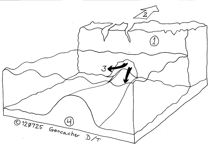
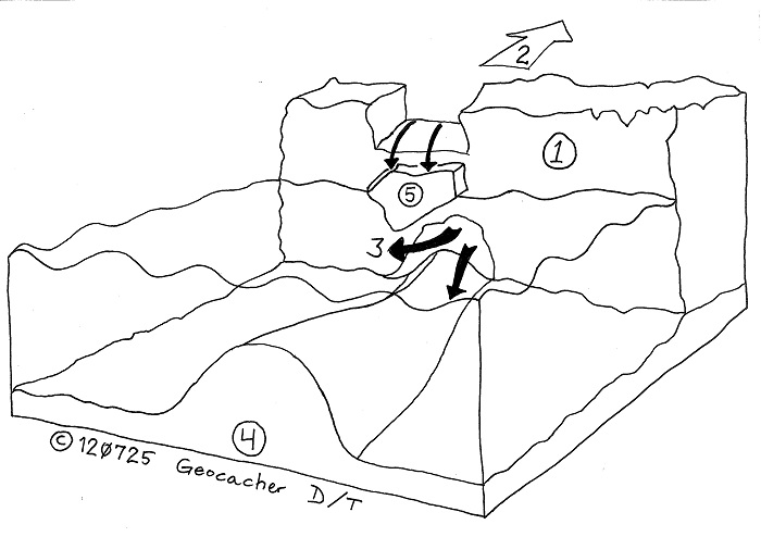
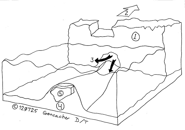
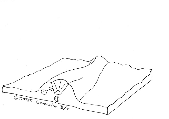
Denna åsgrops hålrum har huserat ett sådant isstycke som skylten nämner. Ett isstycke som lossnade från den avsmältande inslandsisen och landade mitt på denna ås. En ås som skapades av grus som spolades med smältvattnet från inlandsisen. Strömmen av grusbärande smältvatten var koncentrerad kring en öppning vilket medförde att gruset sjönk till botten så pass koncentrerat att åsen bildades. Nedan finner du en illustrationer som visar förloppet.
Eftersom detta är en earthcache finns ingen fysisk cachebehållare med loggbok på platsen. Istället, för att få logga denna earthcache, måste du svara på några frågor. Svaren skickar du till gc2v1c4@takayama.se och se till att svaren ej avslöjas i din loggning. Du kan logga med en gång utan att invänta godkännande, istället hör jag utav mig om dina svar är felaktiga.
Frågor:
1. Vilken diameter har åsgropen?
2. Vilket djup har åsgropens lägsta punkt i relation till vägen? (Ej i relation till åskrönet.)
3. I vilken riktning från åsgropens centrum tycker du kanten är som brantast och vad uppskattar du lutningen till?
4. Tänk dig att betrakta denna dödisgrop från ovan, vad tycker du då den har för form och varför tror du den har denna form?
English:
At this spot you'll find a ridgepit, which one might call a kettle located by a ridge, created by iceblock in the end of the last ice. In this case the ridge is Badelunda ridge, one of Sweden's longest gravel ridge formations. At the site there is good parking space and an information board from County Administration.
The information board translated:
"
Welcome to "Tore's grav" (note: SWE grav would be translated to ENG grave/tomb)
When the ice of the last ice age began to melt in these parts for about 10 000 years ago, a big piece of ice fell off and created a pit in the ground. Today we call this pit Tore grav. The area is geologically and biologically very interesting. Tore grav has been protected as a nature reserve since 1997. The reserve covers 10 hectares.
Tore's grav is not a burial ground. The name refers to the geologically interesting kettle formed during deglaciation of about 10 000 years ago. Next to Tore grav is Malma hill. Malma hill is actually the southernmost part of the ridge Badelunda - one of its longest ridge formations extending from Malma hill through Västmanland into Dalarna. The height difference between the ridgepits lowest point and the crest of the ridge is striking, about 80 meters.
In addition to the geological values of the reserve, there are also a lot of biological interest. The ridgeslope and crest is dominated by ridge spruce trees. Some of the trees are quite large and old. The area also contains dead wood of trees fallen by strong winds. Dead wood is valuable for a wide range of organisms, including insects, fungi and birds. Several rare and vulnerable species associated with old pine forest and dead wood have been spotted here.
The land included in the nature reserve Tore grave is in private ownership. The reserve is managed by the County Administration of Södermans län which can be reached at: Länsstyrelsen, 611 86 Nyköping, Sweden or by phone at +46-(0)155-264000.
"
This ridgepits cavity has hosted such a piece of ice which the sign refers to. A piece of ice that fell off from the melting continental ice and happened to land in the middle of this ridge. A ridge created by gravel flushed with meltwater from the continental ice. The stream of gravel-bearing meltwater was concentrated around an opening. Because of this the gravel sank to the bottom so concentrated that the ridge formed. Below you'll find illustrations showing the process. Below you find an illustraion of how the ridgepit was created.
Because this is an earthcache, it doesn't have a physical cachecontainer or logbook. Instead, in order to log this earthcache, you must answer some questions. E-mail your answers to gc2v1c4@takayama.se and ensure that answers are not revealed in your logging. You post your found log right away without waiting for approval, instead I'll contact you if your answers are incorrect.
Questions:
1. What's the diameter of the ridgepit/kettle?
2. How deep is the lowest point of the ridgepit/kettle in relation to the road? (Not in relation to the crest of the ridge.)
3. In what direction from the center of the rigdepit/kettle do you think the edge is the steepest and what do you estimate the slope for?
4. Imagine a view of this ridgepit/kettle from above, what shape do You reckon and why do You think it has this shape?
Illustrationer/Illustration:
1. Inlandsis. / Continental ice.
2. Rörelseriktning av tillbakadragande inlandsis. / Movement of retracting continental ice.
3. Strömmande vatten som medbringar grus. / Streaming water carrying gravel.
4. Nedsjunkande grus har bildat en ås. / Setteling gravel has created a ridge.
5. Isblock från inlandsisen som täcks av grus och bildar åsgropen när den smälter. / Block of ice fallen from continental ice which is buried in gravel and forms the kettle when it melts.