Sibenicni vrch STOD EarthCache
-
Difficulty:
-

-
Terrain:
-

Size:  (other)
Please note Use of geocaching.com services is subject to the terms and conditions
in our disclaimer.

|
Sibenicni vrch STOD
|
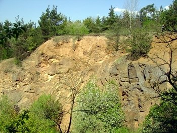
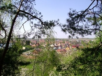
[CZ]  Sibenicni vrch se nachazi 0,5 km jihovychodne od okraje mesta Stod, priblizne 200 metru od koty Sibenicni vrch. Nejblizsi velke mesto je asi 25 km severovychodne Plzen. Pri blizsim prozkoumani zjistime, ze se sklada ze tri opustenych stenovych lomu o prumerne vysce 10 az 15 metru v maximalni sirce 50 metru. Jedna se o barrandienske proterozoikum, tisky a cistecko-jesenicky masiv. Sibenicni vrch se nachazi 0,5 km jihovychodne od okraje mesta Stod, priblizne 200 metru od koty Sibenicni vrch. Nejblizsi velke mesto je asi 25 km severovychodne Plzen. Pri blizsim prozkoumani zjistime, ze se sklada ze tri opustenych stenovych lomu o prumerne vysce 10 az 15 metru v maximalni sirce 50 metru. Jedna se o barrandienske proterozoikum, tisky a cistecko-jesenicky masiv.
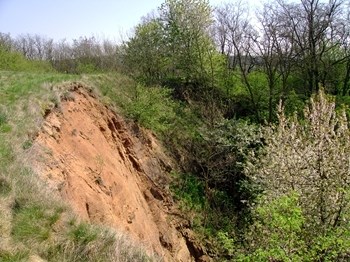
Na zapadnim svahu Sibenicnim vrchu se dobyval lomovym zpusobem stavebni kamen a sterk, ctvrty odkryv byl piskovnou, kde se tezilo granitove eluvium. Plocha byvalych tezeben je 0,3 km2. Hornina je zde prevazne silne navetrala se zretelnou kaolinizaci zivcu a chloritizaci biotitu. Granit je misty slabe usmerneny, patrne jsou velmi cetne pukliny a poruchova pasma (drnovsky granit). Lokalita ma vyznam i z pohledu botanickeho reliktni bor se skalnimi spolecenstvy (vresy lisejniky) ve vrcholovych partiich lomu.
Koncem roku 1996 bylo uzemi Sibenicniho vrchu zaregistrovano jako Vyznamny krajinny prvek. Jedna se o uzemi, ktere zahrnuje byvaly lom, neobhospodarovane louky a stromovou i krovinnou zelen. Ve vrcholove partii rostou zvlaste chranene druhy rostlin - silne ohrozeny vstavac kukacka a ohrozena belozarka liliova. Sibenicni vrch ma vysokou krajinarsko estetickou hodnotu a vysokou uroven bilogicke rozmanitosti. Kolem Sibenicniho vrchu vede take naucna stezka Stodsko a toto je jeji ctvrta zastavka.
Odpovedi zaslete pres profil a na odpoved necekejte, v klidu logujte a pokud by byl nejaky problem s odpovedmi, napisu vam.
NEJDRIVE POSLETE ODPOVEDI A AZ PO ODESLANI LOGUJTE - LOGY BEZ ODPOVEDI BUDOU NEKOMPROMISNE MAZANY!
Otazky pro zalogovani:
- V jakem roce bylo uzemi Sibenicniho vrchu zaregistrovano jako vyznamny krajinny prvek?
- Zmerte nadmorskou vysku u infotabule s GPS a na nejvyssim bode lomu a vypocitejte pribliznou vysku lomu nebo ji odhadnete.
- Prilozte foto Vas nebo GPS u infotabule - dobrovolna podminka (viz. posledni foto v listingu).
zdroj: http//:cs.wikipedia.org
|
[EN]  Gallows Hill is located 0.5 km southeast from the city Stod, approximately 200 meters from point Gallows Hill. The nearest big town is Pilsen about 25km north-east. On closer inspection, we find that it consists of three abandoned quarries on the average wall height of 10 to 15 meters maximum width of 50 meters. This is a Barrandian Proterozoic Gallows Hill is located 0.5 km southeast from the city Stod, approximately 200 meters from point Gallows Hill. The nearest big town is Pilsen about 25km north-east. On closer inspection, we find that it consists of three abandoned quarries on the average wall height of 10 to 15 meters maximum width of 50 meters. This is a Barrandian Proterozoic 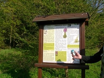 On the western slope of the hill brought Gallows Hill rubble stone and gravel, the fourth outcrop was a sand pit where granite is mined Eluvium. Former mining area is 0.3 km2. The rock is mostly highly weathered, with distinct kaolinization chloritizací feldspar and biotite. Granite is locally weakly streamlined, shows are very numerous fissures and fault zones (Drnov granite). Location is important from the perspective of a botanical relic Committee with rock communities (lichens heathers) in the highest parts of quarries.
In late 1996, the top of the gallows being registered as a significant landscape element. This area, which includes a former quarry, not cultivated meadows and trees and greenery shrublayer. The top part of the growing specially protected plant species - Endangered and threatened orchid Cuckoo Anthericum lily. Gallows Hill has a high aesthetic landscape value and a high level of biological diversity. Around the gallows hill trail leads Stodsko and this is her fourth stop.
Questions for the log:
- In what year was the territory of gallows hill being registered as a significant landscape feature?
- Measure the altitude of the GPS information board at the highest point of refraction and calculate the approximate height of the quarry.
- Place your photo or GPS in the information board - a voluntary condition (see last photo in the listing).
|
|
Design by 3am 2016 ©
|

Additional Hints
(No hints available.)