Devil's Jumps Earthcache EarthCache
-
Difficulty:
-

-
Terrain:
-

Size:  (other)
Please note Use of geocaching.com services is subject to the terms and conditions
in our disclaimer.
The Devil's Jumps are a series of three small hills near the village of Churt in the county of Surrey in southern England. In the 18th century the hills were known as the Devil's Three Jumps. The highest of the three Jumps is Stony Jump. Middle Devil's Jump measures 60 feet (18 m) high and once supported an observatory built by 19th century British astronomer Richard Christopher Carrington.
Surrey has a wide range of mineral deposits, their occurrence being directly related to the geology of the County. Brickmaking, for example, is limited to the southern part of the County where the Weald Clay is exposed, whilst coarse sand and gravel are mainly found as flood plain and terrace deposits in the north-west of the County. Extraction of finer sands is largely confined to a narrow band of the Folkestone Formation running across the centre of Surrey south of the Downs.
At first sight, the Devil's Jumps occupy a typical acidic heathland truncated by rolling hills and a distinctive plateau interspersed with patchy outcrops of consolidated yellow/orange and white sands. These mottled sandy outcrops are the much coarser Folkestone Beds contained within the UGS series of glauconitic quartose sandstones and pebbles. Scattered about the surface are irregular masses of dark ferruginous ironstone known locally as ‘carstone’. These are remnant ironstone seams that underpin or cap conical hills to form the so-called Surrey Hills.
The topmost beds of the Lower Greensand are known as the Folkestone Beds. These are often quite coarse grained rocks and these include current-bedded sands, frequent bands of iron-sandstones ('carstone'), and in places outcrops of leached, pure silver-sands. The latter have been quarried for glass-making, but most extraction is now for builders' sand used for making mortar. There are underground quarries at Reigate and Dorking. The Folkestone Beds form the high ground around Guildford (St.Martha's Hill) and the iron (ferruginous) sandstones the landmarks of Crooksbury Hill and the Devil's Jumps near Frensham. The beds are typically unfossiliferous.
The Devil's Jumps are outcrops of coarse sandstone of the Folkestone Beds of Lower Greensand set among acidic heathland. The three hills are formed of an ironstone known locally as carstone, a sandstone strongly cemented with iron making it resistant to erosion by the elements.
Ironstone is a fine-grained, heavy and compact sedimentary rock. Its main components are the carbonate or oxide of iron, and clay or sand.
This area of Surrey is the uppermost division of the Lower Greensand Group and consists of loosely consolidated quartzose sands, including deposits of clean, white silica sand. Often there are irregular bands of ferruginous sandstone (“carstone”). Small pieces of the dark carstone were often inserted in the mortar joints of stone buildings – a practice known as garneting. The outcrop of the Folkestone Formation is between 0.5 and 1.5 miles wide from the Kent border to the west of Guildford, and then broadens considerably to the south of Farnham.
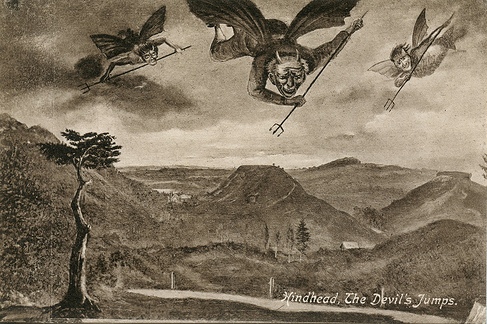
The first mention of the Devil's Jumps appears to be on a map by John Rocque dating to 1765. William Cobbett mentioned the Devil's Jumps in his Rural Rides, first published in 1830. Of the hills he says:
At Churt I had, upon my left, three hills out upon the common, called the Devil's Jumps...in the shape of three rather squat sugar-loaves, along in a line upon this heath...[with] a rock-stone upon the top of one of them as big as a Church tower... William Cobbett, Rural Rides 1830, 2001, p.116.
Folklore
The Devil's Jumps are linked to a variety of local landmarks by folklore, including Mother Ludlam's Cave near the ruins of Waverley Abbey, the Devil's Punch Bowl at Hindhead, the village of Thursley and the parish church at Frensham. The folklore includes various tales. One states that the Devil used to amuse himself by leaping from the top of each hill to the next. This annoyed the god Thor (who lived at 'Thursley' or Thor's Lie) - he picked up a boulder and threw it at the Devil, causing him to flee and leaving the boulder at the Devil's Jumps.
Tales recorded in the 19th century relate that the witch Mother Ludlam had her cauldron stolen by the Devil, who then fled with the witch following behind on her broomstick. Every time the Devil took a great leap he kicked up a hill, and these hills are the Devil's Jumps. He left the cauldron on Kettlebury Hill, from where it was recovered and put in Frensham Church for safekeeping. When the Devil disappeared, he left the valley of the Devil's Punch Bowl.
To log this cache, e-mail me with the answers to the following questions:
1) Estimate the dimensions of the ironstone outcrop on the top of Stony Jump (N51°08.919 W000°45.518)
2) Estimate the distance to the top of the next 'jump' (in a roughly westerly direction) from the bench at the top of the hill.
3) Describe the colour and texture of the 'carstone' here at the devil's jumps, as well as a brief account of the geological processes that might cause ironstone to be formed.
Thanks to Matt Cussack (NT) & Steve Webster (Countryside Ranger, Frensham Common) for granting permission and also to Peter Armstrong for liaising with the National Trust. Geocaching on National Trust property is at your own risk.
Additional Hints
(No hints available.)