 [DE] Wir befinden uns ca. 30 km NW von Antalya im West-Taurus-Gebirge. Der West-Taurus (türkisch: Bati Toroslar) erstreckt sich von der Lykischen Halbinsel ausgehend in einem Bogen um die Ebene Antalyas und folgt dann weiter der Mittelmeerküste in Richtung Südosten.
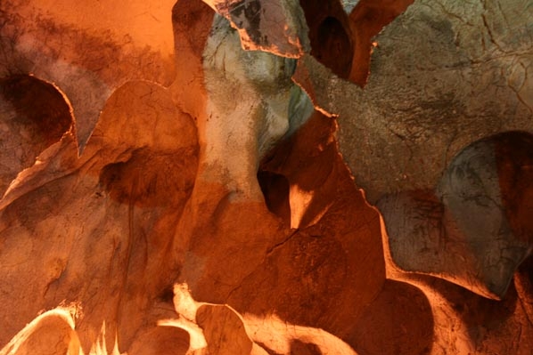
Die 150m Oberhalb vom Museum liegende, aus drei Kammern bestehende Tropfsteinhöhle war mehr als 50.000 Jahre sporadisch bewohnt, älteste Funde sind 200.000 Jahre alt. Die Kammern der Höhle ist durch Kalzitmauern sowie Tropfsteinformationen voneinander getrennt und über enge Gänge miteinander verbunden.
Die Höhle liegt an einem steil abfallenden Hang und ist die größte einst bewohnte Naturhöhle der Türkei.
Türkische Archäologen haben seit 1946 aus der 10,50 Meter hohen Füllschicht Werkzeuge, Gebrauchsgegenstände und Tierknochen aus dem Paläolithikum, Mesolithikum, Neolithikum, Chalkolithikum und der Bronzezeit zutage gefördert, ein Teil der Funde wird im Museum unterhalb ein anderer im Museum von Antalya ausgestellt.
Der Besuch einer Tropfsteinhöhle ist für Kinder und auch Erwachsene immer ein Erlebnis. Natürlich entstandene Hohlräume, in denen Tropfsteine bewundert werden können, wurden in vielen Teilen der Welt für Besucher zugänglich gemacht und sind touristische Attraktionen.
Die Tropfsteine faszinieren uns durch Formenvielfalt, Größe und manchmal auch durch ihre Farbenpracht. Die meisten Tropfsteine entstehen, wenn Niederschlagswasser aus der Luft Kohlendioxid aufgenommen hat und Kohlensäure bildet. Dabei kann Kalkstein aus dem Boden gelöst werden.
Trifft solches Wasser auf einen unterirdischen Hohlraum und fließt zudem nur sehr langsam, so bildet sich im oberen Bereich des Hohlraumes ein Tropfen. Verweilt dieser Tropfen lang genug, so gibt er Kohlendioxid an die Umgebungsluft ab. Dadurch wird Kalziumkarbonat in einer chemischen Reaktion, die auch als "Fällung" bezeichnet wird, gebildet.
Dieser Kalk wird auch als Sinter-Kalk bezeichnet, es handelt sich um eine Ablagerung oder auch Abscheidung. Es bildet sich ein Tropfstein, der von der Decke des Hohlraumes herabhängt und allmählich sogar wächst. Dieses Wachstum kann, sofern niemand den Prozeß stört, Tausende von Jahren andauern.
Ist die Fließgeschwindigkeit des Wassers hoch genug, dann können sich mehr oder weniger regelmäßig Tropfen von der Decke lösen und fallen nach unten. Sie enthalten weiterhin Kalk und transportieren diesen mit sich. Beim Aufprall der Tropfen am Boden wird ebenfalls Kohlendioxid frei und es kann auch hier die Fällungsreaktion stattfinden. In diesem Fall bildet sich ein vom Boden des Hohlraumes nach oben wachsender Tropfstein.
Öffnungszeiten Karain - Höhle:
01. Oktober - 31. März: 08:30 - 17:30
01. April - 30. September: 10:00 - 17:00
Eintritt: 20 TL/Person
Aktuelle Informationen auf der Webseite der Touristeninformation: https://antalyatouristinformation.com/things-to-do/cave/karain/
Wenn Du an der bzw. in der Höhle bist, stelle folgende Recherchen an:
- In der letzten Kammer findest Du eine Tropfsteinform. Wie nennt man diese?
- Sieh Dir die Decken in der Höhle an und versuche zu beschreiben wie diese Formationen entstanden sind.
Für die Logfreigabe sende mir eine Mail (Bitte in Deutsch oder Englisch) mit Deinen Lösungen. Du kannst den Besuch schon loggen, ggf. wird der Log von mir im Nachgang angepasst.
Über ein Foto vom Besuch in der Höhle würde ich mich freuen.
Gemäß der Überarbeitung der Earthcache Richtlinien vom 1. Januar 2011 ist dies aber freiwillig.
 [EN] We are located about 30 km NW of Antalya in western Taurus Mountains. The West Taurus (Turkish: Bati Toroslar) extends from the Lycian peninsula in an arc around the level of Antalya and then follows the Mediterranean coast to the southeast.
The 150m above the museum lying three chambers existing cave was inhabited sporadically over 50,000 years, the oldest Finds are 200,000 years. The chambers of the cave is by calcite walls and stalactite formations separated and narrow passages linked.
The cave is situated on a steep slope and is the largest once inhabited natural caves of Turkey.
Turkish archaeologists made archaelogical excavations since 1946. Inside the 10.50 meters high filler were found tools, utensils and animal bones from the Paleolithic, Mesolithic, Neolithic, Chalcolithic and Bronze Age. A part of the collection is exhibited in the museum beneath another in the museum of Antalya.
Visiting a stalactite cave is for children and adults always an experience. Naturally formed cavities in which stalactites can be seen, were in many parts of the world are available for visitors and tourist attractions.
The stalactites are fascinating variety of shapes, size, and sometimes also by their colors. Most speleothems formed when rain water has absorbed from the air carbon dioxide and carbonic acid forms. This limestone can be dissolved from the soil.
Does this water to an underground cavity, and also flows very slowly, is formed in the upper area of ??the cavity a drop. Lingers long enough to drop this, it gives off carbon dioxide to the atmosphere. This calcium carbonate in a chemical reaction, which is also known as "precipitation" is formed.
This lime is also known as sinter-lime, it is a deposition or deposition. It forms a stalactite that hangs from the ceiling of the cavity and gradually even growing. This growth can, if no one interferes with the process that last thousands of years.
Is the velocity of the water is high enough, then you can more or less regularly drops detach from the ceiling and fall down. They also contain lime and transport it with itself. On impact, the drop on the ground, carbon dioxide is also free and it can also take place, the precipitation reaction. In this case, forms a cavity from the bottom of the top growing stalactite.
Opening hours Karain - Cave:
October 1st - March 30th: 08:30 - 17:30
April 1st - September 30th: 10:00 - 17:00
Entrance: 20 TL/Person
Current information on the website of the tourist information: https://antalyatouristinformation.com/things-to-do/cave/karain/
If you are by or in the cave, ask the following researches:
- In the last room you'll see a form of limestone. How do you call this?
- Look at the ceiling in the cave, try to describe how these formations are created.
For the log approval send me a mail (please in German or English) with your solutions. You can already log the visit, if necessary the log will be modified by me afterwards.
Photos of yours visit in the cave would be nice.
According to the review of the Earthcache guidelines on 1 January 2011, Photos not required for logpermission.
 [TR] Biz Bati Toros Daglari, Antalya'nin 30 km kuzeybatisinda hakkinda bulunmaktadir. Bati Toros (Türk: Bati Toroslar) ve Antalya civarinda bir yayinda Likya yarimadasi uzanir sonra güneydogusunda Akdeniz kiyilarinda izler.
Üç bölümden olusan bulunan müze yukarida 150m, 50.000 yil düzensiz iskan daha magara oldugunu, eski buluntular 200.000 yildir. Magara dik bir yamaçta yer alir ve bir zamanlar Türkiye'de yasamis büyük dogal magaradir. 10,50 metre Paleolitik, Mezolitik, Neolitik, Kalkolitik ve Tunç Çagi yüksek dolgu aletleri, mutfak esyalari ve hayvan kemiklerinden 1946 yilindan beri Türk arkeologlar, koleksiyonunun bir parçasi Antalya müzesinde baska altindaki müzede sergilenmektedir ortaya çikarildi.
Bir sarkit magara Ziyaret çocuklar ve yetiskinler her zaman bir deneyim içindir. Dogal olarak hangi sarkit görülebilir bosluklar olusmus ziyaretçi ve turistik mevcuttur dünyanin pek çok yerinde idi.
sarkit sekilleri büyüleyici çesitli boyut ve bazen de kendi renkleri ile vardir. En buzullasma yagmur suyu hava karbondioksit ve karbonik asit formlardan emmis olusmuslardir. Bu kireçtasi topraktan çözülebilir.
Ve bir yeralti bosluguna bu su mu da bosluguna bir damla üst bölgesinde olusan, çok yavas akar. Oyalaniyor uzun bu düsüs için yeterli, o atmosfere karbon dioksit geliyor. Ayrica "yagis"olarak bilinen bir kimyasal reaksiyon Bu kalsiyum karbonat olusur.
Bu kireç da sinter-kireç olarak bilinen, bir birikimi veya birikimi oldugunu. Bu boslugu tavandan asili yavas yavas hatta büyüyen bir sarkit olusturur. Bu büyüme, kimse süreci ile araya girerse o yil son binlerce.
Daha fazla veya daha az düzenli tavandan ayirmak damla ve asagi düsme, sonra suyun hizi yeterince yüksek mi. Onlar da kireç içeren ve kendisi ile ulasim. Darbe günü, yere düsme, karbon dioksit de ücretsiz ve ayni zamanda yer yagis tepki alabilir. Bu durumda, üst büyüyen sarkit altinda bir bosluk olusturmaktadir.
Açilis kez Karain - Magarasi:
01. Ekim - 30. Mart: 08:30 - 17:30
01. Nisan - 30. Eylül: 10:00-17:00
Giris: 20 TL / kisi
Turist bilgilendirme web sitesinde güncel bilgiler: https://antalyatouristinformation.com/things-to-do/cave/karain/
It's Eger veya boslugunda, asagidaki arama koyun:
- Son odada bir sarkit form göreceksiniz. Ne bu diyorsunuz?
- Bu olusumlarin nasil olusturuldugunu açiklamak için çalisirken, magarada tavana bakin.
Günlük kaydı için bana çözümlerinizi içeren bir e-posta gönderin (lütfen Almanca veya İngilizce). Ziyareti zaten kaydedebilirsiniz, gerekirse günlük daha sonra tarafımdan ayarlanacaktır.
Magaraya ziyaretin bir fotograf içinde, ben ileriye bakmak olacaktir.
1 Earth önbellek politikalarinin gözden göre Ocak 2011, ancak bu istege baglidir.