Steinbruch - bitte nicht klettern! NICHT VON OBEN AN STAGE 1 - Stone quarry - don't climb! DON'T APPROACH STAGE 1 FROM ABOVE
Gerlingens Landschaft ist außergewöhnlich vielgestaltig. Erdgeschichtlich weist Gerlingen Spuren vom Muschelkalk über Keuperschichten hin bis zu Resten von Stubensandstein auf. Die Stadt Gerlingen würdigt diese geologischen Besonderheiten auf 12 Informationstafeln. Die Tafeln liegen verstreut in und um Gerlingen.
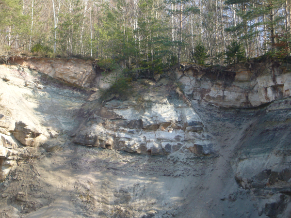
Stubensandstein und Gipskeuper sind unterschiedlich alt. Dennoch gelangten die Sedimente im Steinbruch auf gleiche Höhe. Die gesamte nördliche Scholle des Gerlinger Glemswalduntergrundes sank nach und nach rund 100 Meter in die Tiefe. Dieser linienförmige Höhenversatz gehört zu den Ausläufern eines östlich gelegenen Bruchsystems. Entlang dieser Brüche brach auch der Graben ein, der heute die Filderebene bildet. Bewegungen in der tieferen Erdkruste können auch heute noch in Gerlingen leichte Erdbeben verursachen: das Gebiet liegt in der Erdbebenzone 1, was bei Bauvorhaben berücksichtigt wird.
In der Steinbruchwand spiegeln sich die Ablagerungsbedingungen im Wechsel der Ton- und Sandsteinschichten wider. In niederschlagsreichen Zeiten brachten Flüsse Grobsand in das Germanische Becken, bei Trockenheit nur noch feinste Tonteilchen, die bei still stehendem Wasser als Tontrübe absanken.
Beantwortet bitte zuerst folgende fünf Fragen, indem ihr die Lösung in einer Mail an mich schickt. Log-Freigabe kommt, wenn die Antworten richtig sind. Logs ohne Freigabe werden gelöscht! Es wäre schön, wenn ihr eurem Log-Eintrag ein Foto von euch und eurem GPSr vor dem Steinbruch zufügt. Bitte nicht vor der Infotafel fotografieren!
Frage 1: Wann wird der Afrikanische Kontinent das Mittelmeer, das Rote Meer und den Persischen Golf zusammenschieben?
Frage 2: Wann begann Pangäa zu zerbrechen?
Frage 3: Was durchschneidet die Felswand und kreuzt sich fast an der Geländeoberkante?
Beantwortet die nächsten Fragen bei Stage 1.
Frage 4: Wie hoch ist der Steinbruch (geschätzt)?
Frage 5: In der rechten Ecke des Steinbruchs findet sich ein großer Stein mit einer besonderen Farbe - welche? (siehe Spoiler in 2 m Entfernung)
Gerlingen’s landscape is exceptionally variously shaped. Geologically Gerlingen has traces of shell limestone, different Keuper layers as well as types of sandstone. The town of Gerlingen appreciates these geological features on 12 information panels. The tables are scattered to the four winds around Gerlingen.
This earth cache leads you to a stone quarry with a great view on the historic development of the earth in this area. Sandstone and cast keuper have a different age. Nevertheless in the stone quarry you will see them on the same level. The whole north massif of the Gerlinger underground of the Glemsforest decreased little by little for approximately 100 meter in the depth. This line shaped height offset is part of the branch of an eastern located break system. Alongside that break also the trench broke down, that is today the Filder plain. Movements in the deeper crust of the earth can cause still today light earth quakes in the Gerlingen area - the area still belongs to the earth quake zone 1 – which is considered for new buildings.
In the wall of the stone quarry you can see the different deposition from potter’s clay and sand. In times with heavy rain the rivers brought rough sand in the region, in times with few rain only very small parts of potter’s clay that moved down in stagnant water.
Please answer the following five questions and send me the solution in an email. You will get log permission when the answers are correct. Logs without log permission will be deleted! It would be nice if you would also add a photo of you and your GPSr next to the stone quarry. Please, don't take a photo in front of the panel!
Question 1: When will the African continent the Mediterranean sea, the red sea and the Persian Gulf move together?
Question 2: When started Pangäa to breakup?
Question 3: What transect the rock face and crosses nearly at the upper edge of the surface?
Go to stage 1 to answer the next questions.
Question 4: What is the height of the stone quarry (estimated)?
Question 5: There is a big stone in a particular colour - which one (see Spoiler in 2 m distance)?