|
El Secreto Río
Este caché de la tierra le enseñará todo acerca de las maravillas subterráneas de la río secreto. Tenga en cuenta que existe un derecho de entrada a la sitio de la memoria caché y se le dedica un total de 3-4 horas con el fin de registro de la memoria caché. Usted será capaz de registrar este caché familiar llueva o haga sol y prometo que se sorprenderá de su descubrimientos.
Por favor, ver el final de la página para más recomendaciones.
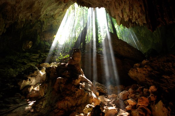
Cerrar sus ojos. Se oye otra cosa que el silencio y el sonido tenue de goteo de agua en el fondo. Imagínese que usted está 80 pies por debajo de suelo con los ojos abiertos en el tono negro. Usted es uno con Madre Tierra. Usted está en algún lugar a lo largo de un tramo de 800 metros de un 14 kilometros de ríos subterráneos que se origina en el interior de la Península y desemboca en el mar. Las luces se encienden de nuevo. Mira y ver a miles de estalactitas de bordes dentados que apunta hacia su cabeza como las puntas de flechas envenenadas maya. Parece que están o en otro planeta o en el conjunto de un éxito de taquilla Película de Hollywood.
|
|
|
|
Sistema Sac Actun - Sistema de Cueva Blanca
Sistema Sac Actun (que significa "Cueva blanca del sistema " en español y maya) es una sistema de cavernas bajo el agua que corre a lo largo de la costa caribeña de Yucatán Península. Entradas a la mentira sistema de cuevas de todo el pueblo de Tulum en el estado de Quintana Roo. La exploración de este sistema fluvial comenzó en el Gran Cenote, a unos 5 kilómetros al oeste de Tulum. En 2007, la cueva submarina Sistema Nohoch Nah Chich estaba conectado en y subsumidos en Sac Actun lo que es la mayor encuesta bajo el agua sistema de cuevas en el mundo. Sac Actun actualmente medidas de 215,2 kilometros y se combina con Sistema Ox Bel Ha. al 182,1 kilometros este es el sistema de cuevas subacuáticas más largo del mundo. Sistema Sac Actun también tiene el título de la cueva más larga en México a 217,3 kilometros de largo al contar dos cuevas secas situadas a lo largo de su recorrido.
La fórmula perfecta para la formación de cuevas: más pesados, la lluvia más frecuente combinado con suave, piedra caliza más soluble crea el más profundo y cuevas más largas.
¿Cómo se formó esta cueva?
Alrededor del 20% de la Península de Yucatán está formada por piedra caliza. La cueva se entra se forma principalmente de piedra caliza que contiene granos de fragmentos del esqueleto de los organismos acuáticos como el coral y foraminíferos. El período Cretácico puso en marcha el inicio de numerosos transgresiones marinas que se sumergen gran parte de la península de Yucatán en cálidas aguas poco profundas hasta el período del Pleistoceno. Durante el Cretácico período de más de 1300 m de estratos de piedra caliza se formaron, y durante el Terciario otro período de 1000 m de sedimentos de carbonato fueron pura depositados. Levantamiento en la zona centro-sur de la península comenzó en el Período Oligoceno. Este levantamiento lento continuó hasta el Pleistoceno período. La mayoría de los depósitos cuaternarios están restringidos a los márgenes de la actualidad de la península. Estos depósitos suelen ser delgadas, que se extiende 1-3 km hacia el interior desde el Caribe. La mayoría de los depósitos del Pleistoceno son el resultado de transgresiones marinas más oriental de Quintana Roo durante el Illinois y Wisconsin edades de hielo.
Las cuevas pueden estar en dos estados: activo o fósiles. Una cueva fósil es normalmente formada por el paso del agua. En ocasiones, el flujo de agua tomará un camino diferente y la cueva, que estaba llena de una vez con agua, se seca. Una cueva de activos es uno donde el agua es siempre que fluye.
|
|
|
|
|
|
|
|
¿Cuáles son esas extrañas formaciones que vemos en este sistema de cuevas?
Estas formaciones distintas se han desarrollado durante millones de años debido a la filtración de agua hacia abajo en las profundidades de la tierra, llevando carbonato de calcio y producir permanente goteo.
|
|
|
|
|
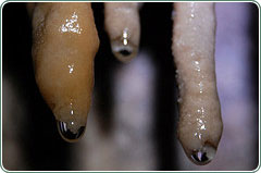
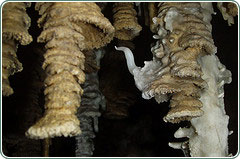
Estalactitas
Mire para arriba. Los carámbanos-como formas son llamadas estalactitas. Como gotas de agua rica en minerales a través de la cueva techo, parte del agua se evapora causando la acumulación de carbonato de calcio hasta que se forme un cono hueco que cuelga del techo. El agua gotea a través de el interior hueco del cono y el carbonato se acumula en la punta.
|
|
|
|

|
Estalagmitas
Mira hacia abajo. Los más formas redondeadas que forman el suelo de la cueva se llaman estalagmitas. Cuando el agua gotea del techo de la cueva sin que se evapora, el calcio carbonato se acumula en el suelo causando la formación de crecer hacia arriba. A diferencia de las estalactitas, estalagmitas no son huecas.
|
|
|
|
|
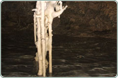
Columnas
Más de estalactitas tiempo y estalagmitas puede crecer lo suficientemente grande que se encuentran y unen creando naturales formas llamadas columnas. En estas columnas se ampliará como el agua de la cueva techo sigue goteando.
|
|
|
|
|
Helictites
Hay otras sorprendentes formaciones minerales dentro de las cuevas, como helictites. Estas se forman cuando hay una obstrucción del hueco de una estalactita, el callejón de tubo donde el agua se filtra a través. Cuando los canales de agua finas se obstruido, los lados de la estalactita de abrir y, finalmente, helictites forma, que a chorro de las estalactitas en muestra extraordinaria.
|
|
|
|
Para registrar este cache por favor complete la siguientes:
-
Tome una foto de sí mismo en uno de los columpios, el uso de su entrada pulsera en la cabaña de entrada. Usted no puede llevar su cámara en la cueva, pero te invitamos a tomar fotos mientras está esperando su recorrido para comenzar. ** Opcional pero recomendado **
-
Dile nosotros lo que el "órgano" se forma de?
-
Dile nosotros lo que el "corazón" se forma de?
-
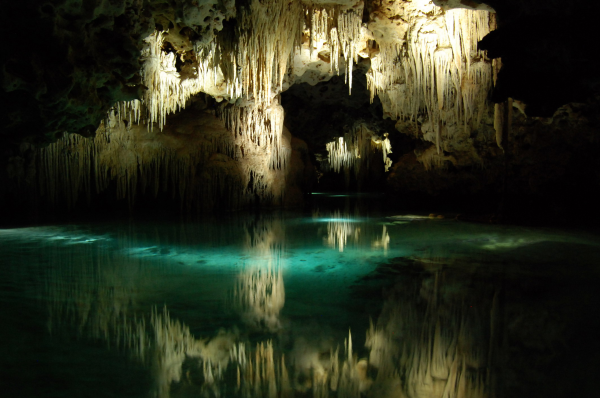
¿Qué color es el agua y por qué?
-
¿Es esta cueva fósiles o activo?
|
|
*** Usted estar entrando en una cueva y nadar a gran profundidad. Las mujeres embarazadas, niños muy pequeños, cualquier persona que sufra de claustrofobia, ha tenido una cirugía reciente, o tiene una condición cardiaca no deben participar.
|
|
The Secret River
This earth cache will teach you all about the underground wonders of the secret river. Please note that there is an entrance fee to the cache site and you will be dedicating a full 3-4 hours in order to log the cache. You will be able to log this family-friendly cache rain or shine and we promise you will be amazed at your discoveries.
Please see the end of the page for further recommendations.
Close your eyes. You hear nothing but silence and the faint sound of trickling water in the background. Imagine you are 80 feet below ground with your eyes open in the pitch black. You are one with Mother Earth. You are somewhere along an 800 meter stretch of a 14 kilometer underground river that originates in the interior of the peninsula and empties into the sea. The lights come back on. Look up and see thousands of jagged-edged stalactites pointing towards your head like the tips of poison Mayan arrows. It looks like you are either on another planet or on the set of a blockbuster Hollywood movie.
|
|
|
|
Sistema Sac Actun – White Cave System
Sistema Sac Actun (meaning "White Cave System" in Spanish and Maya) is an underwater cave system that runs along the Caribbean coast of the Yucatan Peninsula. Entrances to the cave system lie around the Village of Tulum in the state of Quintana Roo. Exploration of this river system started at Grand Cenote, approximately 5 kilometers west of Tulum. In 2007 the underwater cave Sistema Nohoch Nah Chich was connected into and subsumed into Sac Actun making it the longest surveyed underwater cave system in the world. Sac Actun currently measures 215.2 kilometers and combined with Sistema Ox Bel Ha at 182.1 kilometers this is the longest underwater cave system in the world. Sistema Sac Actun also takes the title of the longest cave in Mexico at 217.3 kilometers long when counting two dry caves located along its route.
The perfect formula for forming caves: heavier, more frequent rain combined with softer, more soluble limestone creates the deepest and longest caves.
How was this cave formed?
About 20% of the Yucatan Peninsula is formed by limestone. The cave you will enter is formed mainly of limestone containing grains of skeletal fragments of aquatic organisms like coral and foraminifera. The Cretaceous period launched the onset of numerous marine transgressions that would submerge much of the Yucatan under warm shallow seas until the Pleistocene period. During the Cretaceous period over 1300 m of limestone strata were formed, and during the Tertiary period another 1000 m of pure carbonate sediments were deposited. Uplift in the south-central area of the peninsula began in the Oligocene period. This slow uplift continued until the Pleistocene period. Most Quaternary deposits are restricted to the present margins of the peninsula. These deposits are typically thin, extending 1-3 km inland from the Caribbean. Most Pleistocene deposits are the result of marine transgressions over Eastern Quintana Roo during the Illinois and Wisconsin Ice ages.
Caves can be in two states: fossil or active. A fossil cave is typically formed due to the passage of water. On occasion, the water flow will take a different path and the cave, which was once filled with water, will become dry. An active cave is one where water is always flowing.
|
|
|
|
|
|
|
|
What are these strange formations we see in this cave system?
These distinct formations have developed over millions of years due to water filtering down into the earth's depths, carrying calcium carbonate and producing permanent dripping.
|
|
|
|
|
Stalactites
Look up. Those icicle-like shapes are called Stalactites. As mineral-rich water drips through the cave ceiling, part of the water evaporates causing calcium carbonate to accumulate until it forms a hollow cone that hangs from the ceiling. Water drips through the hollow inside of the cone and the carbonate accumulates at the tip.
|
|
|
|
|
Stalagmites
Look down. Those more rounded shapes forming from the floor of the cave are called Stalagmites. When water drips from the cave ceiling without evaporating, calcium carbonate accumulates on the floor causing the formation to grow upwards. Unlike Stalactites, stalagmites are not hollow.
|
|
|
|
|
Columns
Over time stalactites and stalagmites can grow large enough that they meet and join creating natural forms called columns. These columns will broaden as water from the cave ceiling continues to drip.
|
|
|
|
|
Helictites
There are other surprising mineral formations inside caves, such as helictites. These are formed when there is an obstruction of a stalactite's hollow, tube-like passageway where the water filters through. When the slender water channels become clogged, the sides of the stalactite open up and eventually form helictites, which jet out of the stalactites into extraordinary displays.
|
|
|
|
To log this cache please complete the following:
-
Take a photo of yourself on one of the swings, wearing your entrance bracelet at the entry hut. You cannot take your camera into the cave but you are welcome to take pictures while you're waiting for your tour to begin. **Optional but recommended**
-
Tell us what the "Organ" is formed from?
-
Tell us what the "Heart" is formed from?
-
What color is the water and why?
-
Is this cave fossil or active?
|
|
*** You will be entering a cave and swimming deep underground. Pregnant women, very small children, anyone who experiences claustrophobia, has had a recent surgery, or has a heart condition should not participate.
|