(ENG) ČELO OUTDOOR MUSEUM
ACCESS: From the village of Kal-Koritnica, that lies 3 km from Bovec in the direction towards the Trenta valley. You can park the car on the parking site by the main road (waypoint PARKNG). Follow the track to Svinjak Mountain in the initial part. After about 20 minutes of walk, the track running to Celo forks to the left and after some tens of meters reaches the fortified gun positions.
Path is well sign-posted and marked with black-red stripes.
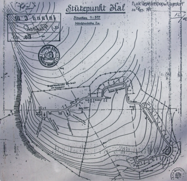
[image 1, Situation]
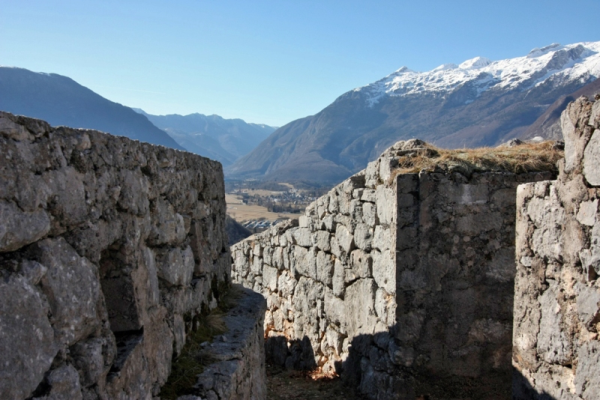
[image 2, Walled trenches, view towards Bovec]
HISTORICAL OUTLINE: The Austro-Hungarian fort lies on the slope of Mt. Svinjak, which rises with its altitude of 1653 m above the Bovec basin. The site with the fort is called Čelo by the locals, while the Austro-Hungarian army gave the name of Stützpunkt Kal to the fort during the war. It acted as part of the Bovec blockade (Sperre Flitsch) that served as the defence against Italian attacks. The Austrians started its construction in November 1914 and completed it just before the war on the Isonzo Front began, in the spring of 1915, when they also built in it two 12-cm guns M.80. The transportation of the guns to these positions was a very demanding task, because each gun weighed more than 6 tons. The fort played an important role in the defence of the valley section of the battlefield in the Bovec basin, since it was possible to shell the roads towards Kluze and to the Trenta valley from the fort. Due to continuous shelling by the Itallian artillery the fort was damaged at several places. Its squad was forced to abandon it and fortify their positions somewhat lower, under the bottom right section of the fort, where a large cave was made for the two guns. In the history of battles in the Bovec basin these two guns are recorded as the Kal Battery (Batterie Kal). Before the Austro-Hungarian-German breakthrough in the Bovec basin in the 12th Isonzo battle, a tremendous artillery introduction was performed in the night hours of 24th October 1917, in which the guns from the positions at Čelo also took part.
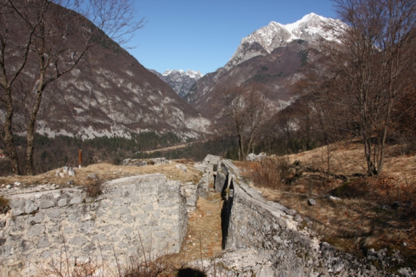
[image 3, Trench to gun positions, view towards Fort Herman and Kluže]
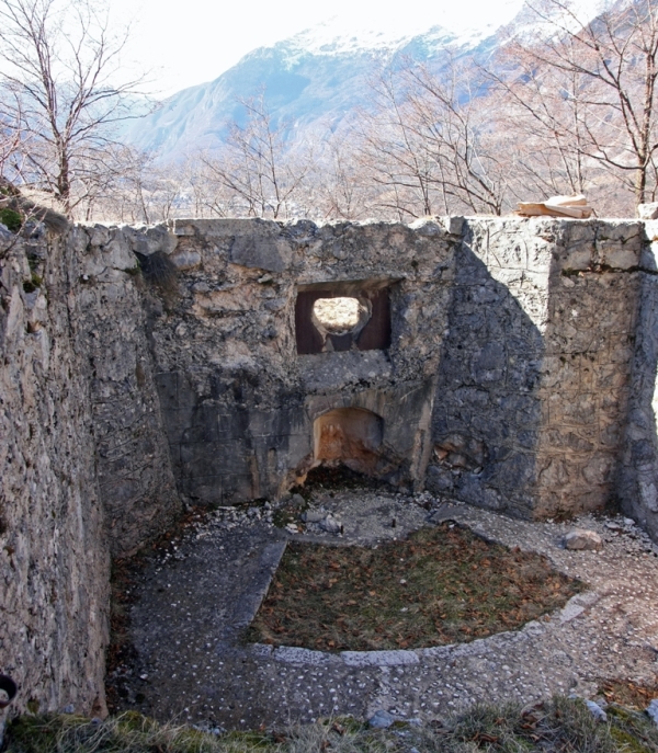
[image 4, Gun position]
PRESENT SITUATION: An outdoor museum is arranged on the slope of Svinjak. The Austro-Hungarian fort at Čelo is located on the slope with an exceptional panoramic view over the Bovec basin, Mt. Rombon and other surrounding mountains. It has been quite well preserved until today. No major reconstruction works have been done here, the site was only cleaned and arranged. The main part of the fort consists of a 200-metre long trench with built walls connecting the two gun positions with a kitchen, an observation post, two dwelling structures for 40 men and a shelter for 20 soldiers. The trench had altogether 150 loopholes for riflemen.
The Society Dreizehn-Dreizehn (13-13) of Bovec, in collaboration with the Ustanova »Fundacija Poti miru v Posocju« (»Walks of Peace in the Soča Region Foundation«) is in charge of the reconstruction and maintenance of the Austro-Hungarian positions at Celo.
Note: Description text is taken from website of Fundacija poti miru v Posočju:
http://www.potimiruvposocju.si/index.php);
Photo: vane_si, information board;
SOČA HIGHLIGHTS SERIES ALREADY HAS SEVERAL GEOCACHES PUBLISHED. YOU CAN ADD YOUR OWN GEOCACHE TO THE SERIES IF IT COMPLIES TO THE FOLLOWING:
1. Cache points to one of the natural wonders, cultural or historical monuments anywhere in the Soca valley.
2. Access to the cache is easy, preferably not far from possible parking spot; At least, it doesn't take more than 1 hour to get from car to cache and back.
3. Cache is not too difficult to find.
4. Add "SHXX" in front of your geocache name, where "XX" represents the corresponding serial number of the cache in the series.
(SI) ČELO - MUZEJ NA PROSTEM
DOSTOP: Iz vasi Kal - Koritnica, ki je od Bovca oddaljena 3 km v smeri proti dolini Trente. Parkirate lahko na parkirišču ob glavni cesti (točka PARKNG). V začetnem delu sledite planinski poti na hrib Svinjak. Po približno 20 minutah hoje se pot, ki vodi na Čelo, odcepi v levo in po nekaj deset metrih doseže utrjene topniške položaje.
Pot je lepo označena s tablicami na lesenih stebričkih in markirana z rdeče-črno črto.
[image 1, 2]
ZGODOVINSKI ORIS: Avstro-ogrska utrdba se nahaja na pobočju Svinjaka, ki se s 1653m nadmorske višine dviga nad Bovško kotlino. Domačini temu kraju pravijo Čelo, med prvo svetovno vojno pa ga je avstro-ogrska vojska poimenovala Stützpunkt Kal. Le-ta je predstavljala del Bovčke zapore (Sperre Flitsch), ki je služila obrambi pred italijanskim napadom. Avstrijci so jo začeli graditi novembra leta 1914, končali pa tik pred spopadom z Italijo, spomladi leta 1915, ko so vanjo vgradili če dva 12-centimetrska topa M.80. Transport topov na te položaje je bil zelo zahteven, saj je vsak tehtal več kot 6 ton. Utrdba je igrala pomembno vlogo pri obrambi dolinskega dela bojišča v Bovški kotlini, saj je bilo z nje možno obstreljevati cesto proti Klužam in cesto v Trento. Zaradi nenehnega obstreljevanja italijanskega topništva je bila na več mestih poškodovana. Posadka jo je bila prisiljena zapustiti in položaje utrditi nekoliko niže, pod spodnjim desnim delom utrdbe, kjer so zgradili veliko kaverno za oba topa. Topa sta v zgodovino bojev v Bovški kotlini zapisana pod imenom Baterija Kal (Batterie Kal). Pred avstro-ogrsko-nemškim prebojem v Bovški kotlini v 12. soški bitki je bila v nočnih urah 24. oktobra 1917 izvedena strahovita topovska priprava. Pri tem so sodelovali tudi topovi na položajih na Čelu.
[image 3, 4]
DANAŠNJE STANJE: Na pobočju Svinjaka je urejen muzej na prostem. Avstro-ogrska utrdba na Čelu leži na izjemno razglednem pobočju, s katerega se odpira razgled na Bovško kotlino, Rombon in ostale okoliške gore. Do danes se je kar dobro ohranila. Tu niso bili opravljeni večji obnovitveni posegi, območje je bilo le očiščeno in urejeno. Glavni del utrdbe sestavlja 200 m dolg strelski jarek z zidanimi stenami, ki povezuje dva topniška položaja s kuhinjo, opazovalnico, dvema bivališčema za 40 mož in zaklonom za 20 vojakov. Strelski rov je imel skupaj 150 strelskih lin za strelce s puškami.
Obnovo in vzdrževanje avstro-ogrskih položajev na Čelu izvaja Društvo Dreizehn-Dreizehn (13-13) iz Bovca skupaj z Ustanovo »Fundacija Poti miru v Posočju«.
Viri: USTANOVA FUNDACIJA POTI MIRU V POSOČJU, spletna stran:
http://www.potimiruvposocju.si/index.php);
Foto: vane_si, informacijska tabla;
SERIJA SOŠKIH ZNAMENITOSTI IMA ŽE CELO VRSTO ZAKLADOV. TUDI VAŠ ZAKLAD JE LAHKO DEL SERIJE, ČE LE USTREZA NASLEDNJIM POGOJEM:
1. Zaklad opozarja na naravno, kulturno ali zgodovinsko znamenitost kjerkoli v dolini Soče.
2. Dostop do zaklada je enostaven, ne predaleč od možnega parkirišča; Pot od avta do zaklada in nazaj ne vzame več kot 1 uro.
3. Zaklada ni pretežko odkriti.
4. Pred ime svojega zaklada dodajte "SHXX", kjer XX predstavlja ustrezno zaporedno številko zaklada v seriji.