Geologisches Denkmal in Bubenreuth EarthCache
Geologisches Denkmal in Bubenreuth
-
Difficulty:
-

-
Terrain:
-
Size:  (not chosen)
Please note Use of geocaching.com services is subject to the terms and conditions
in our disclaimer.
Es ist nur schwer vorstellbar, dass das Gebiet um Bubenreuth von
Meer
überspült war. Es liegt allerdings schon über 200 Millionen Jahre
zurück.
Das Wasser ging langsam in Etappen zurück und formte das heutige
Gebiet.
Heute ist von der Vergangenheit nichts mehr zu erkennen,
nur das hier errichtete Denkmal und die Infotafel erinnert noch an
diese Zeit.
It is unbelievably, that this area was deep under the ocean. But it
was more
then 200 million years ago.
The ocean goes slowly in stages back and formed the today’s
territory.
Today, nothing can be seen anymore from the past,
only the monument and the info board reminding at this time.
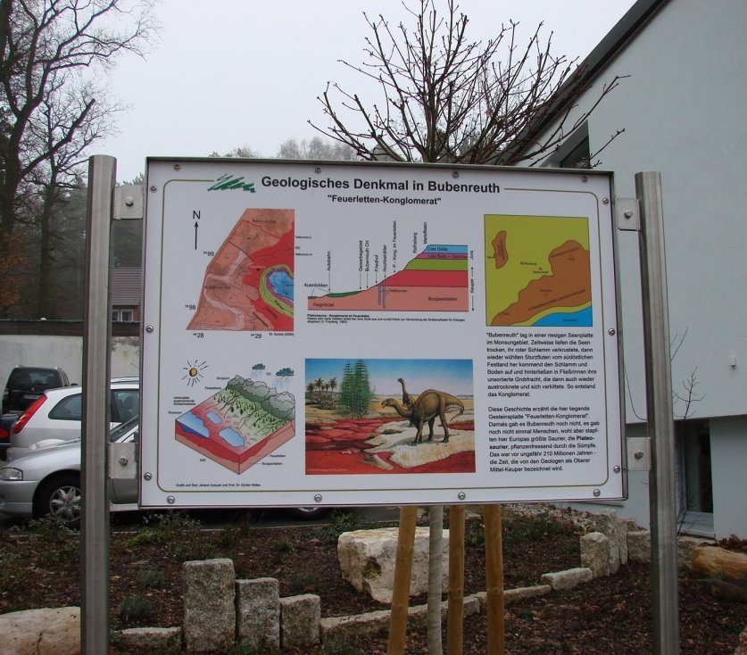
Infotafel
Bei Bauarbeiten zu einem Wasserhochbehälter stieß man zwischen
den
Schichten Burgsandstein (diese Steine wurden zum Bau von
Burgen
verwendet) und den Sandsteine des Rhätolias, im Bereich des
Feuerletten
auf dieses sehr harte und seltene Gestein, aus welchem das
Denkmal
errichtet wurde.
Die bemerkenswerten Steine des geologischen Denkmals sind aus
der
Trias / Jura-Zeit und sind ungefähr 210 Millionen Jahre alt. Es
handelt sich
dabei um eine Gesteinsplatte, ein so genanntes
„Feuerletten-Konglomerat“
Bubenreuth, so ist dort zu lesen, lag einst auf einer riesigen
Seenplatte
im Monsungebiet.
(Monsun, aus dem arabischen "mausim"= Jahreszeit, ist eine
großräumige
Luftzirkulation der unteren Troposphäre im Gebiet der Tropen)
Zeitweise waren die Seen trocken, ihr roter Schlamm
verkrustete.
Dann wieder wühlten Sturzfluten, vom südöstlichen Festland
kommend,
Schlamm und Boden auf und hinterließen in Fließrinnen ihre
unsortierte
Grobfracht, die dann wiederum austrocknete und verkittete.
So entstand das Konglomerat.
Menschen gab es damals hier noch nicht, aber es lebten hier Europas
größte
Saurier, die Plateosaurier, die Pflanzenfressend durch die Sümpfe
stampften.
Belegt wird dies durch Knochenreste im Gestein.

Feuerletten-Konglomerat
Quellen:
1. Infotafel
2. Wikipedia
3. Erlanger Tageblatt Ausg. 2010
Logbedingungen:
Begebt euch zu dem Geologischen Denkmal an den Listingkoordinaten
und
macht bitte ein Foto (optional) mit euch oder euren GPS und
dem
Feuerletten-Konglomerat im Hintergrund.
Fügt dieses Bild zu eurem Log hinzu.
Die Fotos müssen so gestaltet sein, dass die Fragen für die
Lösung nicht
erkennbar sind.
Frage 1: wie tief ist jeweils die Bohrung der beiden
Tiefbrunnen?
Frage 2: welche 2 Schichten liegen zwischen Lias Beta und
dem Burgsandstein?
Frage 3: was sind die Hauptbestandteile des
Konglomerat
und messe die Diagonale des oberen Konglomerats ± 5cm
Frage 4: beschreibe wie sich das Konglomerat anfühlt
Sende eine Mail (über Geocaching contact) mit den
Antworten
English description
During construction work for a water tower the worker found
between
the layers of castle sandstone (these stones were used to build
castles)
and Rhätolias sandstone, in the layers of the Feuerletten
Formation
this very rare and hard rock, from which the monument was
erected.
The remarkable geological stones of the monument are from the
Triassic / Jurassic period and are about 210 million years
old.
This is rock plate is called a " Feuerletten
Conglomerate”
You can read on the information board, Bubenreuth was once on
a huge lake district in the monsoon area.
(Monsoon, from the Arabic "mausim" = season, is a large-scale
air circulation in the lower troposphere in the area of the
tropics)
At times, the lakes were dry, her red mud encrusted.
Then burrowed flash floods from southeastern mainland coming
mud and soil on and left in their flow channels unsorted rough
stones,
then dried again and agglutinated. Thus was born the
conglomerate.
At this time there was no human being living in this area, but it
lived
Europe’s largest dinosaur, the Plateosaurier, the herbivorous
stomped
through the swamps. This is confirmed by the bones in the
rocks
Sources:
1. Info board
2. Wikipedia
3. Newspaper „Erlanger Tageblatt“ issue 2010
Log requirements:
Please go to the info board at the listing coordinates and
take
a picture (optional) to yourself and the GPS and the
Feuerletten-Konglomerat
in the background. Please add this picture to your log.
The photos must be designed so that the questions for the
solution
can´t be seen.
Give an answer to following questions:
question 1: how deep is the borehole in each of the two deep
wells?
question 2: Name of the 2 layers which are between
“Lias Beta” and the “Burgsandstein”?
question 3: what are the main components of this
conglomerate
and measure the diagonal ± 3" of the upper one this
conglomerate
question 4: describe how the conglomerate feels
Send a mail (through Geocaching contact) whit your
answerer
Logs show the solution in image or text are
extinguished without announcement!
Additional Hints
(No hints available.)