To find the container, follow these
clues:
In the bowels of Golden Acre a treasure was found.
Across from the exact spot, the secret lies under the ground.
Behind the sign, a magnetic box awaits,
To see if the hunter is favoured by the fates.
Cache Description:
The Dutch East India Company started a
settlement at Table Bay for one main reason: access to fresh water.
Their single most important source of water was a river that few
know about today. The Versche (Fresh) River begins where Platteklip
and Silverstream join at the base of the mountain, and once ran
into the bay, roughly where Adderly Street now lies. Today, this
river runs mostly underground, but previously it watered the
fertile fields of city bowl where the Khoi-khoi grazed their
flocks. Later, these waters resupplied ships and the Company
Gardens were planted along its banks.
Van Riebeek built a small
‘reservoir’ at the river mouth so ships could get fresh
water. However, this was little more than a mud hole. After many
complaints, Van Riebeek’s replacement, Zacharias Wagenaar,
ordered the construction of a stone and brick reservoir. On August
6th 1663, three years before he laid down first stones of the
Castle, construction of the reservoir began. The reservoir was
built adjacent to the "Fort of the Good Hope" and was about 45
metres long by 15 metres wide. Steps ran down to it from which
sailors could fill barrels. In 1671, a channel was designed by W.
Mostert (of Mostert's Mill) to link the reservoir with ships at
sea.
When work on the Castle began, the Varsche
Rivier was again put to use in the Castles moat. The river was
further employed to fill the canals (a "Gracht" in Dutch) around
the growing settlement. Soon there was a Heerengracht, a
Buitengracht, and a Keizersgracht, crossed by little bridges, all
fed from the mountain river. By 1760, the Gracht system had
completely replaced Wagenar’s reservoir and was used until
1845. The remains of the reservoir were built over and lost to all
but archives and stories.
In the 1970s, archaeologists at the South Africa
Museum (now Iziko) knew that beneath the ‘Old Station’
lay valuable heritage and there was a proposal for SANLAM to
develop the property. After extensive urging, the City Council made
a pioneering move by including a clause in the deed of sale
explicitly providing for archaeological investigation of the site.
Thus the development included archaeological monitoring of the
destruction of the station and the excavation for the building of
the Golden Acre. Among many other treasures found, In 1975,
monitors identified “very old brick” and notified the
(then) National Monuments Council. After archaeological excavation
and investigation the remains were confirmed as Wagenaar's
reservoir.
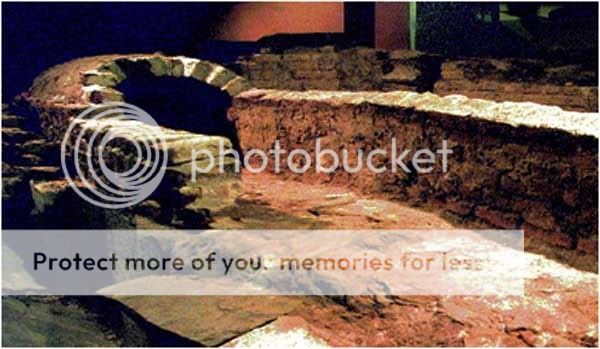
These are the oldest surviving structures
relating to the establishment of the Cape Colony. After much debate
between developers and local, Provincial and State authorities a
portion of these remains were preserved in place (what we in the
business call 'in situ'). The overall cost of preservation,
1,5 million rand, was borne by the State, Cape Provincial
Administration, Cape Town Municipality and SANLAM. The task was not
small: in addition to the archaeology, parts of the proposed
building needed redesigning, a museum quality display needed to be
created and built, and the ruins needed protection while
foundations of Golden Acre were blasted metres into the bedrock and
the building was erected around them. The display and the ruins
were declared a National Monument, and opened to the public, along
with the Golden Acre mall, at the end of July, 1979. The ruins are
visible from three different floors with protective glass and
explanatory displays.
Today, almost 350 years after they were built,
and over 35 years since they were re-discovered and preserved, you
can still see, in their original position, the very beginnings of
the Cape Colony.
I forgot to check when I was checking up on the cache, but
according to the internet...
The Golden Acre is open:
Monday-Friday: 9:00 AM – 5:30 PM
Saturday: 9:00 AM – 2:30 PM
Sunday: Closed
This spot will never be muggle free, so please
use stealth when retrieving and replacing.
Sources and Further Reading
Avery, G. 1979. The Ruins On Cape Town's Golden Acre. The South
African Archaeological Society Newsletter 2:6-8.(Link)
Voigt, E. 1977. The Destruction of Archaeological Evidence in South
Africa. The South African Archaeological Bulletin
32:107-112.(Link)