
 As
you embark or continue your journey to discover and explore
beautiful and historic rocks, waterfalls, peaks, creeks and other
wonders, please keep in mind that these places need to remain wild
and protected so that they may be enjoyed by others for generations
to come. Please be diligent in respecting these sites by doing the
following:
As
you embark or continue your journey to discover and explore
beautiful and historic rocks, waterfalls, peaks, creeks and other
wonders, please keep in mind that these places need to remain wild
and protected so that they may be enjoyed by others for generations
to come. Please be diligent in respecting these sites by doing the
following:
- Please keep trash with you at all times, do not leave it behind
in these pristine places.
- Bury human waste 6 inches deep, make certain you are at least
50 paces away from any water source and PLEASE bring your toilet
paper and sanitary items back out with you.
- Keep food and all scented items on your person at all
times.
- Support wildlife by allowing them to find their own food, do
not feed them.
- Allow plants to grow and water to stay clean by staying on
trails, bike paths and roads.
Thank you, Yosemite Wilderness Management
There is a small parking area parallel to the one way road. If
you choose to cross the road be careful of the traffic.
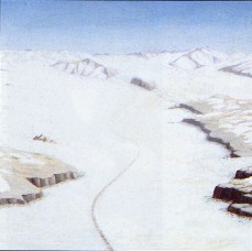
Yosemite Valley is often described as a typical glacial valley.
But where is the typical “U’ shaped valley that is used
to identify a glacially cut valley? (See Tuolumne River Glacial Valley Geomorphology).
To find that shape, we will have to explore the more recent
geologic history of Yosemite Valley.
 Geologic
studies have shown that glaciers have moved through Yosemite Valley
during a number of glacial episodes. Between 2.5 million to 200,000
years ago about 36 different glacial episodes have been identified
in the Yosemite area. All of these episodes are combined into what
is called the Pre-Tahoe glaciations. However, one episode, the
Sherwin Glaciation is the most notable. It began between 900,000
and 800,000 years ago and lasted over 300,000 years. The valley was
completely filled even extending a short way above the rim. The
glacier extended as far as El Portal. However, Half Dome still
stuck some 900 feet above the glacier. At that time the highest
mountains were only about 9,500 feet above sea level.
Geologic
studies have shown that glaciers have moved through Yosemite Valley
during a number of glacial episodes. Between 2.5 million to 200,000
years ago about 36 different glacial episodes have been identified
in the Yosemite area. All of these episodes are combined into what
is called the Pre-Tahoe glaciations. However, one episode, the
Sherwin Glaciation is the most notable. It began between 900,000
and 800,000 years ago and lasted over 300,000 years. The valley was
completely filled even extending a short way above the rim. The
glacier extended as far as El Portal. However, Half Dome still
stuck some 900 feet above the glacier. At that time the highest
mountains were only about 9,500 feet above sea level.
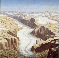
It was during the Sherwin glaciation that the majority of the
erosion of Yosemite Valley is thought to have taken place. As the
glaciers from the Tenaya and Merced Glaciers combined the thickness
and velocity of the merged glacier gouged out a deep basin in the
area of the Ahwahnee Hotel and Camp Curry. This basin is about
2,000 feet below the current valley floor. A second basin was
gouged out near Cathedral Spires (about 1,000 feet below the valley
floor) and a third smaller one near the Cascades.

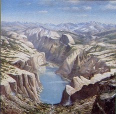
As the Merced Glacier began melting, its terminal moraine dammed
the Merced River forming a lake in Yosemite Valley. Sediments from
the glacial meltwater quickly filled in large basins the glaciers
gouged in the granite bedrock. It is thought that flucutations in
the advance and retreat of the Sherwin Aged Merced Glacier created
at least two different lakes in the valley forming a flat valley
floor.
 The
more recent glaciations of Tahoe and Tioga age also formed glaciers
that flowed through the valley. The thickness and extent of the
Tahoe and Tioga glaciations were much smaller than the Sherwin
Glaciation and did not have the erosive power to reexcavate the
lake sediments deposited by the Sherwin aged Lakes.
The
more recent glaciations of Tahoe and Tioga age also formed glaciers
that flowed through the valley. The thickness and extent of the
Tahoe and Tioga glaciations were much smaller than the Sherwin
Glaciation and did not have the erosive power to reexcavate the
lake sediments deposited by the Sherwin aged Lakes.
Thus at the end of the Tioga Glaciation (the most recent event
where a glacier flowed through the valley) a terminal moraine was
deposited on top of the prior lake sediments. The road cut provides
a cross section of this terminal moraine. The El Capitan Moraine
created a final Yosemite Lake. As before, this lake continued to
fill the valley with sediment.
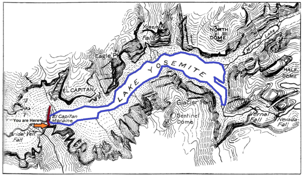
Prior to 1897, the lake had not fully filled, and Yosemite
Valley was swampy and mosquito infested. Annual floods continued to
fill in the valley much as Mirror Lake is currently being filled
(Mirror Lake, Mirror Meadow - Which one is it?).
In 1897, the El Capitan Moraine was dynamited to create a deeper
channel though it. This allowed greater drainage of the valley,
eliminating the swamps and causing the Merced river to erode down
in its channel. The dryer valley has also allowed pines to begin to
grow in the valley floor.
Logging questions:
- The text "GC2MM1A El Capitan Moraine – The Lake Yosemite
Dam" on the first line
- The number of people in your group (put in the log as
well).
- Describe the valley floor upriver and down river, how does the
valley change?
- Examine the river channel and sides. What evidence of the
dynamiting remains? Why is that so?
How the depth and ages of the different incarnations of Lake
Yosemite was determined. The depth and age of the sediments beneath
the current valley floor were determined using seismic studies.
Sound waves move at different speeds through material of different
densities. Additionally, sound waves will reflect off of surfaces
where materials of two different materials touch. By setting off
controlled explosions and placing microphones at known distances, a
three dimensional map of the subsurface can be created. This study
was completed by BENO GUTENBERG JOHN P BUWALDA and ROBERT P SHARP
in 1935 and 1937.
The following sources were used to generate this
cache:
- BENO GUTENBERG JOHN P BUWALDA and ROBERT P
SHARP. SEISMIC EXPLORATIONS ON THE FLOOR OF YOSEMITE VALLEY,
CALIFORNIA. Copyright © 1956, The Geological Society of America,
Inc.
http://gsabulletin.gsapubs.org/content/67/8/1051.short
- Matthes 1962. Marks of Time: Yosemite and the
High Sierra. EL CAPITAN MORAINE AND ANCIENT LAKE YOSEMITE. Sierra
Club Bulletin, January, 1913, pages 7-15.
http://www.yosemite.ca.us/library/matthes/lake_yosemite.html
- CLYDE WAHRHAFTIG. GEOMORPHOLOGY OF THE YOSEMITE
VALLEY REGION, CALIFORNIA. Bulletin 182Geologic Guide to the Merced
Canyon and Yosemite Valley, California U.S. Geological Survey,
Menlo Park, California and University of California, Berkeley,
California
http://www.nps.gov/history/history/online_books/geology/publications/state/ca/cdmg-bul-182/sec4.htm
- http://www.yosemite.ca.us/formation/
- Roadside Geology of Yosemite Valley. Road Guide
is adapted from "The Living Geology of the Sierra Nevada, Great
Valley and Coast Ranges of California" edited by Garry Hayes.
http://virtual.yosemite.cc.ca.us/ghayes/roadside.htm
- Leavitt, Amanda. 2008. Glaciers – A Force
Like No Other Evolution of Yosemite: A Tale of Glaciers Past.
January 1.
http://www.indiana.edu/~sierra/papers/2007/leavitt.pdf