
 As
you embark or continue your journey to discover and explore
beautiful and historic rocks, waterfalls, peaks, creeks and other
wonders, please keep in mind that these places need to remain wild
and protected so that they may be enjoyed by others for generations
to come. Please be diligent in respecting these sites by doing the
following:
As
you embark or continue your journey to discover and explore
beautiful and historic rocks, waterfalls, peaks, creeks and other
wonders, please keep in mind that these places need to remain wild
and protected so that they may be enjoyed by others for generations
to come. Please be diligent in respecting these sites by doing the
following:
- Please keep trash with you at all times, do not leave it behind
in these pristine places.
- Bury human waste 6 inches deep, make certain you are at least
50 paces away from any water source and PLEASE bring your toilet
paper and sanitary items back out with you.
- Keep food and all scented items on your person at all
times.
- Support wildlife by allowing them to find their own food, do
not feed them.
- Allow plants to grow and water to stay clean by staying on
trails, bike paths and roads.
Thank you, Yosemite Wilderness Management
There is a small parking lot at the trailhead to Sentinel Dome.
A short hike brings you to the edge of the valley where you can
look out to the north toward Yosemite Falls. The road and trail are
closed in the winter.
The view from the coordinates shows the hanging valley of
Yosemite Falls. The falls are fed by Yosemite Creek, the largest
stream on the north side of the valley. However, this was not
always so.
It is likely that more that 36 different glaciations covered the
Sierra Nevada beginning as early as 2.5 million years ago to about
200,000 years ago. Of these the Sherwin Glaciation was likely the
largest and longest, beginning about 900,000 years ago and lasting
over 300,000 years. This glaciation likely created the majority of
features of Yosemite Valley.
At the end of the Sherwin glaciation, Yosemite Creek followed a
path to the west of its current channel. It was fed by a small
drainage between Yosemite and Indian Canyon Creeks, likely
resulting in an ephemeral flow. The trail from the valley floor to
the top of the falls uses this ancient falls.
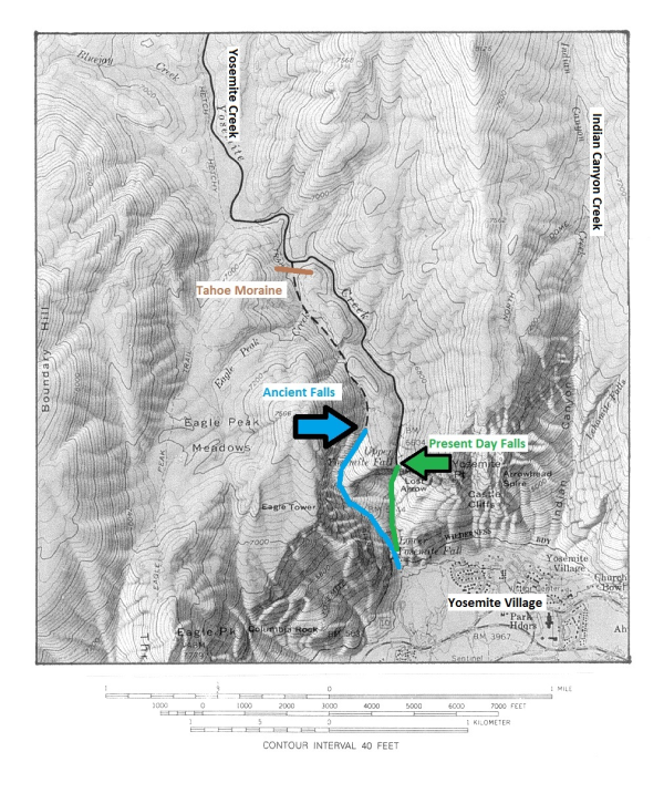
About 130,000 years ago, the Tahoe glaciation reached its peak.
As the glaciers receded, a moraine blocked the ancient channel of
Yosemite Creek and redirected the flow to its current channel. Now
the falls create the highest waterfall in North America, a total
drop of 2,425 feet (the height of the Sears Tower and the Eiffel
Tower combined). The ancient falls have since been filled by a
rockfall.
Logging questions:
- The text "GC2MEC6 A View of Ancient Yosemite Falls " on the
first line.
- The number of people in your group (put in the log as
well).
- Which was steeper, the ancient falls or the current falls?
- Are the current or ancient falls higher? .
The following sources were used to generate this
cache:
- Matthes, Francois. 1930 USGS. Geological Survey
Professional Paper 160 Geologic History of the Yosemite Valley.
http://www.nps.gov/history/history/online_books/geology/publications/pp/160/index.htm
Last Updated: 28-Nov-2006
- http://www.yosemite.ca.us/yosemitefallsfacts.html
- Huber, King. 2003 Yosemite Falls a New
Perspective. Sierra Nature Notes, Volume 3, March 2003.
http://www.sierranaturenotes.com/naturenotes/YosFalls.htm
- Leavitt, Amanda. 2008. Glaciers – A Force
Like No Other Evolution of Yosemite: A Tale of Glaciers Past.
January 1. http://www.indiana.edu/~sierra/papers/2007/leavitt.pdf
.