Welcome to Canyonlands National Park - The Needles
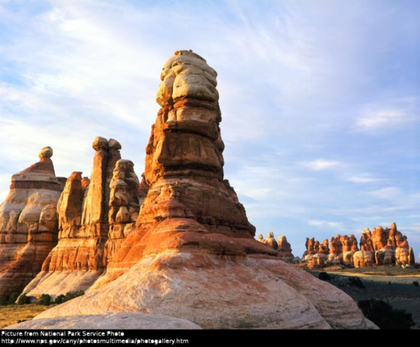
(Example of a Needle in Chesler Park)
We visited Canyonlands National Park during our vacation in September. We enjoyed the landscape, the nature and some nice talks to rangers but we can't believe that there is no Earthcache in Needles District. So this should be the first one. This cache will teach you something about the emergence of the Needles and a little bit about the history of the Canyonlands National Park.
If you like you can upload some pictures of your trip through needles district.
Stage2 is located on the 2WD-part of the Road to Elephant Hill.
Let's start with our Cache.
Stage1 (History)
N 38°10.083'
W109°45.587'
Go to the visitorcenter and pay your entrance fees. On your way back to your vehicle you find a monument about „Bates E. Wilson“.
Bates was the moving force to create Canyonlands National Park and the first superintendent of Canyonlands N.P.On the top of the plaque you see an image.
How many vessels with a grasp can you count? Count only the grasps you can see on the image.
If you are not sure:The small 2 things in the right of Wilson do not count.
The number is A.
Also have a look at the birth- and death date of Bates E. Wilson.
B=The result of Death date-Birth date
Stage2(Geology)
N 38°9.163'
W109°48.630'
The Needles are a series of spires. The spires consist of 2 colored layers which are 245 to 286 million years old. Sand was blown from a dune field and formed the white bands. The red bands came from sediment carried down by streams from a mountainous region. These layers of sand were laid down on top of each other and created the distinctive rocks you can see today. These 2 layers are located on the top of a different layer. The 2 described layers slided over the subterranean layer. This results in a series of parallel valleys. Erosion formed these ridges to pinnaccles, also called Needles.
You have to drive to a sign explaining you The Needles. At this point you can have a look at the impressive needles.
Read the sign and answer the following Questions according to the plaque:
-
2 types of stones/minerals are needed to form the needles.
C= The name of the shortest type
D= The other name
-
2 types of erosion forces formed the ridges in pinnacles.
E=The name of the shortest force.
F= The other force.
Now you 're finished. Send an E-Mail to boerderunner@googlemail.com. Write the following subject:
“GC2M10H-A-B-C-D-E-F” (without “”)and include your Nickname in the message. Now you can log this cache as found. If everything was ok, you get a canned response, containing the absolute log permission. If something was wrong we will send you another canned response and we will contact you as fast as possible.
Here's an example. If you have the following Answers:
A=1, B=50, C=marmot, D= granite E=wind F=sun.
The subject is: “GC2M10H-1-50-marmot-granite-wind-sun” without “”
We hope you had fun, enjoyed the tour and learned a bit about the emergence of The Needles
Thanks to Heidi Willey (Concessions Specialist/Special Park Use Coordinator ) for the permit.

Information compiled from:
Plaques in Canyonlands National Park
http://www.nps.gov/cany/naturescience/needles.htm