 Español
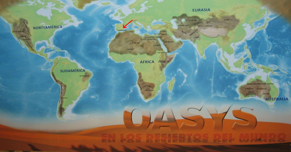
¡El desierto de Tabernas es el único desierto oficial en Europa!
Está localizado en la provincia de Almería (España), a unos 30 km al norte de la capital, Almería, en los términos municipales de Tabernas. El desierto esta protegido como Paraje Natural desde 1989.
El desierto de Tabernas esta ubicado entre la Sierra de los Filabres en el norte, la Sierra Alhamilla en sur-sureste y la Sierra Nevada en el oeste. Encima una parte del desierto forma parte de la Sierra Alhamilla y tiene una vegetación rica y espacio vital para muchos pájaros.
El desierto esta aislado de las corrientes húmedas del cercano mar Mediterráneo en una zona en una zona de poca pluviosidad como es Levante español de la península Ibérica.
Junto con las altas temperaturas medias a lo largo de todo el año (18 °C) y uno de los mayores niveles de horas de sol posibles (3000 h), conforman el clima seco que da lugar a este verdadero desierto. Todas estas características se ven, además, agravadas por el efecto Foehn.
Hace medio millón de años el corredor entre la Sierra Alhamilla u la Sierra Filabres estaba cubierto por el mar Mediterráneo. Con el tiempo el nivel del agua ha bajado y el desierto de Tabernas se ha formado como una cuenca de sedimento.
Así se ha sedimentado en el antiguo fondo del mar arena y barro y el sol y la lluvia (pocas veces, pero cuando – muy intensa) han formado por la erosión este exótico e impresionante paisaje del desierto de Tabernas.
Un desierto de arena es un desierto con una superficie que contiene principalmente arena de cuarzo, formado por la erosión del suelo de un desierto de grava.
Solo hace unos 150 años el desierto estaba cubierto con un bosque grande. Pero el uso de las personas no ha dejado nada del bosque y todos intentos de una repoblación forestal han fallado hasta ahora.
En las coordenadas arriba hay un sitio con varias puntos de información y mucha arena.
Tarea 1: Coge una mano llena de arena y determina el tamaño del grano de arena mas grande y del grano de arena mas pequeño.
Léete bien todas las placas de información y contesta a las siguientes preguntas:
Pregunta 2: ¿Entre que valores oscilan las temperaturas aquí en el desierto?
Pregunta 3: ¿Cuánta lluvia se cae aquí en el año?
Pregunta 4: ¿Qué es la distancia de aquí hasta Granada? Mapa: „El Pueblo de Tabernas”
Pregunta 5: ¿Qué tamaño tiene toda la superficie del desierto?
Manda un correo con las respuestas a mi perfil y espérate al permiso de loquear.
¡Solamente se acepta las respuestas de las placas de información!
¡Se borra inmediatamente cualquier foto de las placas de información en los logs!
Si quieres, puedes añadir a tu log una foto de ti o tu GPS con la autopista A-92 en el fondo.
¡Muchas gracias a “seekmuch” por la traducción al Español!
¡Que lo paséis bien!
´Wössje´
 Deutsch
Die Wüste von Tabernas ist die einzige, anerkannte Wüste in Europa!
Sie liegt in der Provinz Almería, etwa 30 km nördlich der Provinzhauptstadt Almería, auf dem Gebiet der Ortschaft Tabernas. Diese Wüste ist seit 1989 als Naturschutzgebiet ausgewiesen.
Die Wüste von Tabernas liegt zwischen der Sierra de los Filabres im Norden, der Sierra Alhamilla im Süd-Südosten und der Sierra Nevada im Westen. Ein Teil der Wüste ist Bestandteil der Sierra Alhamilla und bietet eine reichhaltige Vegetation und Lebensraum für zahlreiche Vögel.
Die Wüste von Tabernas ist von den feuchten Winden des Mittelmeers abgeschnitten und liegt in der sogenannten spanischen Levante, einer Zone mit wenig Regenfällen.
Hohe Temperaturen während des ganzen Jahres (die durchschnittliche Temperatur liegt bei 18° C), sowie eine der am meisten der Sonne ausgesetzten Gegenden (3000 Sonnenstunden) erzeugen das trockene Klima, das eine echte Wüste ausmacht; verstärkt werden diese Effekte durch Föhnwinde.
Vor einer Million Jahren war der Korridor zwischen der Sierra Alhamilla und der Sierra de Filabres vom Mittelmeer bedeckt. Im Laufe der Zeit ist der Meeresspiegel gesunken und die heutige Wüste von Tabernas wurde zu einem Sedimentbecken.
So haben sich auf dem einstigen Meeresboden Sand, Ton und Schlamm abgesetzt und Sonne und Regen (selten, aber dann heftig) haben durch die Erosion die bizarre und eindrucksvolle Landschaft der Wüste von Tabernas geschaffen.
Eine Sandwüste ist eine Wüste mit einer Oberfläche, die überwiegend aus Quarzsand besteht, der durch die Bodenerosion einer Kieswüste entstand.
Noch vor etwa 150 Jahren war die Wüste von einem großen Wald bedeckt. Doch die Nutzung durch den Menschen hat nichts als die Wüste zurückgelassen und sämtliche Aufforstungsversuche sind bisher fehlgeschlagen.
An den oben genannten Koordinaten befindet sich ein Platz mit mehreren Informationstafeln und viel Sand!
1. Aufgabe: Nimm dir eine Hand voll Sand und bestimme die Größe des kleinsten und größten Sandkornes.
Studiere alle Informationstafeln aufmerksam und beantworte folgende Fragen:
2. Frage: Zwischen welchen Werten schwanken die Temperaturen hier in der Wüste?
3. Frage: Wie viel Regen fällt hier jährlich?
4. Frage: Wie weit ist es von hier nach Granada? Info-Karte: „El Pueblo de Tabernas“.
5. Frage: Wie groß ist die Fläche der Wüste?
Sende eine Email mit den Antworten an mein Profil und warte auf die Logfreigabe.
Es werden nur die Antworten von den Informationstafeln akzeptiert!!!!!
Fotos von den Infotafeln werden sofort gelöscht!
Freiwillig kann ein Foto von dir oder deinem GPS mit der Autobahn A-92 im Hintergrund deinem Log angefügt werden!
Viel Spaß!
´Wössje´
 English
The desert of Tabernas is the only, recognized desert in Europe!
It is located in the province of Almeria, 30 km north of the provincial capital of Almeria, in the area of Tabernas village. This desert is a nature reserve since 1989.
The desert of Tabernas lies between the Sierra de los Filabres in the north, the south-southeast Alhamilla Sierra and the Sierra Nevada to the west.
A part of the desert is also a part of the Sierra Alhamilla and offers a rich vegetation and habitat for many birds.
The desert of Tabernas is cut off from the moist winds of the Mediterranean and is located in the so-called Spanish Levant, an area with little rainfall
. High temperatures throughout the year, (the average temperature is 18 ° C), and one of the most sun-exposed areas (3000 hours of sun) produce the dry climate, which constitutes a real desert, reinforced these effects by foehn winds.
A million years ago, the corridor between the Sierra Alhamilla and the Sierra de Filabres from the Mediterranean was covered. Over time, the sea level dropped and today's desert of Tabernas became a sedimentary basin.
Thus has settled on the former seabed sand, clay and mud and rain and sun (rare, but then violently) created by the erosion of the bizarre and spectacular scenery of the desert of Tabernas.
A sanddesert is a desert with a surface consisting predominantly of quartz sand, which was formed by the erosion of a gravel desert.
As recently as 150 years, the desert was covered by a large forest.
But the use by people has nothing, as the desert left behind
and all attempts of afforestation have failed so far.
At the given coordinates is a place with several information panels and lots of sand!
1. Task: Take a handful of sand and determine the size of the smallest and largest grain of sand.
Study all the information boards carefully and answer the following questions:
2. Question: Between which values vary the temperatures here in the desert?
3. Question: How much rain falls here in each year?
4. Question: How far is it from here to Granada? Info Card "El Pueblo de Tabernas”.
5. Question: How large is the area of the desert of Tabernas!
Send an email with the answers to my profile and wait for the log permission.
Only the responses from the information boards will be accepted!!!!!
Photos of the information boards will be deleted!
Voluntarily a photo of yourself or your GPS with the A-92 in the background can added to your Log!
Have fun!
Greetings ‘wössje’