Here there is a small rock shelter in the Table Mountain
Sandstone (TMS) where you can see evidence of how these rocks were
deposited.
Sandstone is a sedimentary rock. This means it was deposited as
sediment (dirt), and later, under pressure, turned into rock by a
process known as ‘lithification’. These sands were laid
down in an alternating pattern that could be the result of either
river or beach deposits, possibly both. At this locality, the
layers alternate between planar bedding and cross bedding.
Planar bedding typically occurs when sediment is in a low
velocity environment. This means that the sand was not moving
quickly when it was laid down. This can happen in a slow moving
river bottom, a mud flat, or at the bottom of a lake or ocean. This
kind of deposition results in mostly flat pancake-like layers, one
on top of another.
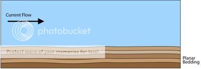
Figure 1: How planar bedding forms
These layers form natural breakage (or cleavage) planes that the
resulting rock will easily fracture along. Often the surfaces
exposed reveal the kind of depositional environment that the rock
formed under. Two common environments that can be seen in the TMS
are desiccation cracks and ripple marks. At Waypoints 1 & 2, a
few meters from the shelter, you can see examples of these
tell-tale exposed surfaces.
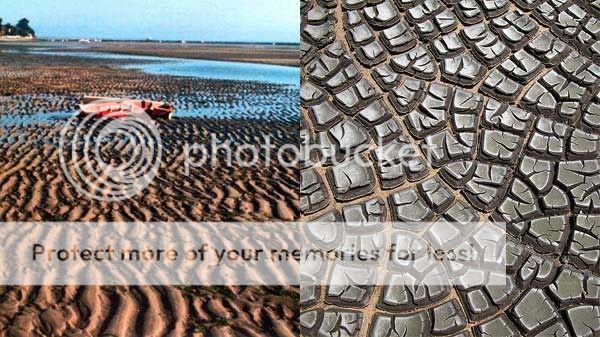
Figure 2: Modern examples of ripple marks and desiccation
cracks
Cross-bedding occurs when sand grains move more quickly as they
do in waves or wind. This can happen at a beach coast, in dunes, or
along the edges of a braided river channel.
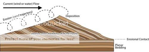
Figure 3: How cross-bedding forms
If planar bedding resumes, as it does here, the top of the cross
bedding is eroded off and topped by the flat pancake layers again.
These alternating environments result in changes in the rock strata
that can be seen in their profile. This is the origin of the kind
of cross-section you can see at this earthcache locality, and many
other places around the mountain.
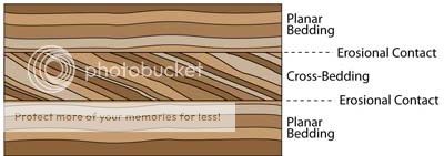
Figure 4: A cross section showing the alternating patterns of
deposition
These rocks do not contain any fossils, and as a result these
layers are very clear. However, the lack of fossils make it
difficult to interpret the environment these rocks formed in. One
clue lies in the colour of the rocks. When sediment is formed at or
near the surface, the abundance of oxygen in the air will often
oxidize the iron in the sediment, giving it a maroon or reddish
colour. Sediment that forms further away from the atmosphere, in a
more anaerobic (lacking in oxygen) environment, will typically have
a grey/black or greenish colour.
- At Waypoints 1 or 2, what kind of surface is preserved?
- What kind of depositional environment does this reflect?
- Given the colour of the sandstone, what can you say about the
environment where these sands were deposited?
- Why would the presence of animals, like clams for example,
effect the resulting bedding patterns?
- Optionally, Take a photo of a feature you find interesting at
the site, or of your team at the site and post with your log. If
you do photograph either waypoint, please don’t indicate
which one!
Sources and further reading:
Compton, J.S. 2004. The Rocks & Mountains of Cape Town.
Double Story, Cape Town.
Ripple marks -
Wikipedia, the free encyclopedia
Cross-bedding -
Wikipedia, the free encyclopedia
Lithification
- Wikipedia, the free encyclopedia
Sedimentary
Structures