The published coordinates will take you to a place called Concordia. The actual ‘place’ Concordia is not much more than a point on a map. You will not find any permanent structures at Concordia, just a few tents and maybe the odd rock shelter (temporary rock walls covered with tarpaulin).
What makes Concordia so special?
Concordia, dubbed the Throne Room of the Mountain Gods by the famous mountaineer/photographer Galen Rowell, is a truly remarkable place. A number of major glaciers converge at this point to form the Baltoro Glacier, and in the process creates a natural amphitheatre that offers a 360 degree panoramic view of the surrounding mountains.
Four of the world’s 14 eight-thousand metres peaks stand shoulder to shoulder, their soaring summits rising into the sky. The region boasts the greatest concentration of 8000-metre peaks anywhere in the world, and more than 100 summits that exceed 7720 meters/25000 feet in altitude.
Some of the more famous peaks in the area are: Gasherbrum_IV, Chogolisa, the Golden Throne, Marble Peak, Angel Peak, Bride Peak, Mustagh Tower, and in the distance Paiju Peak and Masherbrum – not to mention the four eight-thousand metres giants themselves: K2, Broad Peak, and Gasherbrum I and II.
 View of K2 from Concordia, looking up the Godwin Austen glacier
How to get there
Contact a trekking company that offer trips to Concordia/K2 Base Camp via the Baltoro glacier. They will be able to arrange the necessary permits, transport, porters etc. A quick search on the internet will present you with a number of candidates.
Treks into this region are undertaken ‘expedition style’ – everything needed for survival being carried in by a team of porters: food, tents, bedding, tables and chairs, fuel, cooking apparatus and personal belongings. There are no villages along the way, and nowhere to collect supplies. A group of 16 people would need an entourage of some 80 porters.
To get to Concordia you will have to:
Fly from Islamabad (or travel by bus) to Skardu, the capital of the north-eastern province of Baltistan and then take a 6-hour jeep journey to Askole, the last village you encounter before the ±16 day trek commences.
Walk for three days up the Boltoro river to Paiju, and from there climb up to the Boltoro glacier, which leads to Concordia and ultimately K2 Base Camp.
At night you will camp on the Boltoro glacier. There is very little by way of a path to follow through the glacial moraine strewn on the surface of the glacier - rock and rubble, stones and dirt. Each year the route changes as the glacier buckles and breaks up, altering its course.
After ±8 days of trekking you reach Concordia, where you can camp for a number of days, exploring the surroundings, and doing a day’s walk to K2 Base Camp.
Weather permitting, it is possible to return to Skardu via the Gondogoro La (pass). At 5940m/19520 feet, however, this pass can be treacherous when deep snow prevails. Under these circumstances, it is necessary to return the same way – back down the Boltoro glacier.
Glacier Terminology:
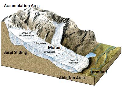 Original image sourced from Essentials of Geology 9th Edition
Alpine glacier – glacier that forms at high altitude and “flows” down a mountain.
Ice Sheet - mass of glacier ice that covers surrounding terrain and is greater than 50,000 km². (Source)
Accumulation area - the area of the glacier where temperatures are cold and snow collects, adding mass to the glacier.
Ablation area - the area of the glacier where temperatures are warmer, so some of the glacier melts. It could also be the point where the glacier meets the ocean.
Terminus - the front, or end of the glacier. (Source)
Basal Sliding - glacier sliding over the bedrock due to meltwater under the ice acting as a lubricant. (Source)
Moulin - vertical tubes that carry meltwater down through the glacier. (Source)
Crevasse - crack in the glacier surface. (Source)
Serac - block or column of ice formed by intersecting crevasses on a glacier. (Source)
Icefall - occur when the glacier bed steepens and/or narrows. (Source)
Ogive - light and dark bands of ridges and valleys found at the base of icefalls. (Source)
Rock Flour - fine-grained, silt-sized particles of rock generated by grinding of the rock by the glacier. (Source)
Moraine - debris (soil and rock) accumulated by the glacier. (Source)
More about Baltoro Glacier
The Baltoro glacier is an Alpine glacier in the Karakoram mountain range in the Gilgit-Baltistan region of Pakistan. It is the second longest glacier outside of the poles and has been measured to a depth of more than a mile.
 Sheet 3, Karakoram Maps, 1:200 000, Leomann Maps, ISBN 0906227682
The surface of the glacier has a life all its own, with huge chunks of sharp-pointed ice ‘floating’ on top of the glacier. There are also clear streams of melt-water on the surface of the glacier flowing for many kilometres through narrow channels, before being sucked down into the bowels of the glacier. This water later emerges as a fully-fledged river, that passes down the Boltoro valley to the mighty Indus river, three hundred kilometres away.
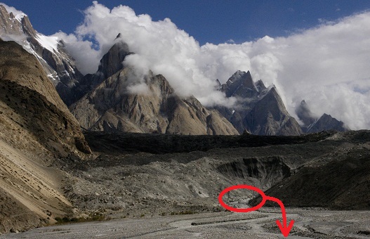 Baltoro Glacier Terminus
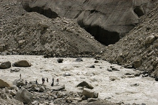 Water flowing from Baltoro Glacier
Like all Alpine glaciers, the Baltoro glacier gouges out the rocks as it moves through the valley. You will find signs of this everywhere around you but it is best observed from Paiju Camp. From the camp, look down to the river – you will notice that the valley is very wide and flat. If you look at the size of the river compared to the width of the valley, it becomes clear that a force of nature, other than the river, shaped the valley.
You’ll also notice the colour of the river. As the glacier moves, it picks up rocks, some of them very large. The repeated melt/freeze cycles that occur inside and beneath a glacier pry them from the ground. The rocks on the bottom are ground together as they're carried along. The glacier's weight breaks down the rocks, crushing them into a fine powder (rock flour). It is the rock flour that gives the water the milky/grey look.
Because of the size of the glaciers, it is very difficult to see the actual places where the various glaciers merge with the Baltoro glacier. From ground level it just looks like one big ice-block. It would be ideal to get an aerial view to really appreciate the sight. Hopefully you'll have the opportunity to climb up one of the peaks to gain some height to see more of the glacier. If not, use a tool like Google Earth to see an aerial view of the glacier.
How to log this cache
By the time you get to Concordia you will have an intimate knowledge of (and a healthy respect for) the workings of alpine glaciers. Submit the following to us via email:
1.) Measure the length of the glacier from the terminus to Concordia.
To do this you will have to mark the terminus as a waypoint on your GPS. Do the same at Urdukas Camp. You now have 3 waypoints - the Terminus, Urdukas & Concordia (published coordinates). Use your GPS to calculate the distance between the 3 waypoints. Remember - It is not safe to walk right up to the point where the water flows from the glacier so a coordinate reading at the point where you climb up onto the glacier will be sufficient.
2.) Do a comparison of the water that flows from the Terminus and the water that you see flowing in the channels on the surface of the glacier. Include a photo of the terminus, taken from a safe distance.
3.) OPTIONAL - Upload a photo of yourself (or your GPSr), taken from Concordia (published coordinates), with K2 in the background (weather permitting!). All other photos (and stories) related to you trek to Concordia will also be welcome
Please send answers to sa.urbancampers@gmail.com
You are welcome to log your visit before you get confirmation from us, however, logs without emails will be deleted.
References
Essentials of Geology (10th Edition) by FK Lutgens, EJ Tarbuck, and D Tasa. ISBN-10: 0136003761
For more detail on glaciers go to the HowStuffWorks website
For more detail on the Baltoro glacier go to Wikipedia