Isola Tiberina / Tiber Island EarthCache
Isola Tiberina / Tiber Island
-
Difficulty:
-

-
Terrain:
-

Size:  (other)
Please note Use of geocaching.com services is subject to the terms and conditions
in our disclaimer.
ENGLISH:
(Go to Italian text)
This earthcache is about the geological aspect of the Tiber Island (Isola Tiberina).
You can read more about the island here,- including the historical and cultural aspects.
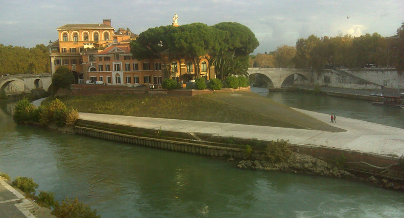
The Tiber Island is the only island in Tiber River in Rome.
It is about 270 m. long and 67 m. wide at the widest point.
This boat-shaped formed island is a so called ait, a type of a small island that is seen in rivers, like here and in the River Thames in England.
But how was the Tiber Island made and why does it have this shape?
One story goes that it was built on the body of the hated tyrant Tarquinius Superbus (510 BC) who was thrown in the river. Other more likely explanations are that it was created of waste from ships passing, or that a overloaded ship once sank here.
But none of these theories are very possible,- also, because the existance of Tiber Island has been reported in the earliest written descriptions, before any heavy merchant activities was going on in the river.
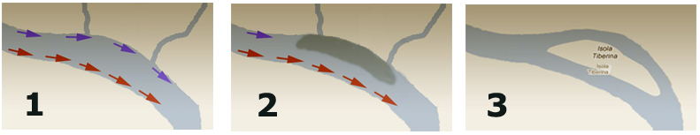
One of the most likely geological explanation is this:
(for additional info, see my drawing below with the 3 frames)
The Tiber island is located within a meander (bend in the river) where the floodplain is narrow (675 m). The outside of the meander cuts into the rocks of the Capitoline Hill and the Janiculum Hill.
Most river channels meander when there is equilibrium between the water flow, deposition of sediment and erosion. The channel is usually deepest on the outside (here southside) of a meander because centrifugal forces tears at the riverbank, when water rounds in the curve. Lower water forces on the inside (here northside) of the meander allow sand and gravel to accumulate and form a sand/gravel/clay-bar, which gradually enlarges to form the island - taking the shape of the curving meander in the river. Once 2 or 3 tributaries emptied into the river, at this place, carrying extra gravel/sand(sediment) to the creation of the island.
The river then could have split during a flood, cutting an additional channel across the inside of the meander and thereby creating the island we see today (see frame #3 in the drawing).
The early Romans reinforced the edges of the island with rock (later concrete), to protect the island. Therfore the boat-shape form is basically unchanged for hundreds of years.
Logging the earthcache:
To do this earthcache, you will have to take a walk around this beautifull island at the lower location, do some tasks at the points and answer the 4 questions below. Then you must email us the answers (do not post them in your log).
You do not have to wait for our response to log the cache on geocaching.com.
If your answers are wrong, we will contact you, and maybe ask for a picture (with GPS) proving you have been on the island.
Anyway - we would be very happy if you optional (not required) with your log will post a picture from somewhere on the island or/and a picture of the Tiber Island.
Only loggings from visits after the release date of this cache are acceptable.
Stairs. At the starting coordinates there is a staircase going down to the lower part of the island, where you have to visit these points:
1. point (N41 53.400 E012 28.686)
Here is a decrease/fall in river course.
How deep (approximately) is the decrease/fall in meter?
2. point (N41 53.392 E012 28.740)
Look to both sides of the island.
At what side of the island is the water going fastest, SW or NE?
3. point (N41 53.452 E012 28.684)
How many meter are there from below (where you are standing) to the bridge (higher part of the island)?
You can measure this with you GPS by visiting both levels (and look at the hight on your GPS), or just measure by eye.
4. point (N41 53.460 E012 28.520)
How wide (in meter) is the island at this point?

Source of information:
The seven hills of Rome : a geological tour of the eternal city, by Grant Heiken, Renato Funiciello, and Donatella De Rita
Wikipedia
Please be aware that access to the island will be closed some times, for example during the film festival in the summertime. BUT you should be able to answer all questions by looking down at the island from above
ITALIANO:
Questo earthcache é basato sull’aspetto geologico dell’Isola Tiberina.
Puoi leggere altro materiale informativo - incluso gli aspetti storici e culturali - su questo link.
L’Islola Tiberina é l’unica isola del Tevere a Roma.
È lunga 270 m. e larga 67 m. nei sui punti estremi e ha la forma di una barca.
Ma come si é formata l’Isola Tiberina e perché ha questa forma?
Una delle storie dice che l’isola é stata costruita sul corpo dell’odiato tiranno Tarquinius il Superbo (510 avanti Cristo) dopo essere stato gettato nel fiume. Un’altra spiegazione piú probabile é che l’isola é stata create dall’accumularsi dei rifiuti gettati dalle imbarcazioni di passaggio o l’affondamento di una barca molto grande piena di rifiuti.
Ma probabilmente nessuna di queste teorie é valida poiché l’esistenza dell’isola giá é stata riportata su alcuni testi prima dell’attivitá mercantile svoltasi sul Tevere.
Una delle spiegazioni geologiche piú verosimile:
(per ulteriori informazioni, osservate il mio disegno sotto posto).
L’Isola Tiberina é locata nell’interno di un meandro dove il fiume si ristringe (675 m.). La parte esterna del meandro taglia in due le roccie dei colli Capitolense e Gianicolense.
Molti fiumi formano meandri per creare un equilibrio tra il flusso delle acque, disposizione di sedimenti ed erosione. Il fondo del fiume é di solito piú profondo sulla parte esterna (in questo caso la parte a sud) del meandro perché la forza centrifuga dell’acqua tende a spingere verso la riva del fiume passando per la curva. L’acqua bassa si dirige verso l’interno (la parte nord) del meandro permettendo a sabbia e pietre di accumularsi e formare una barriera che pian piano si allarga formando un’isola che prende la forma del meandro del fiume. Il resto completata con l’aggiunta di un paio di gettate artificiali di pietre e sabbia.
Dopodiché il fiume potrebbe aver formato nel corso di un’alluvione un altro canale nella parte interna del meandro creando cosí l’isola come la si puó vedere ai nostril giorni.
I romani rinforzarono le estremitá dell’isola con rocce (piú tardi con cemento) per proteggerla ulteriolmente.
Per loggare questa earthcache:
Per fare questo earthcache devi fare il giro di questa magnifica isola nella parte bassa , risolvere dei compiti sui punti e rispondere alle quattro domande sottostanti. Dopodiche mandaci una mail con le risposte (non mandarcile nel tuo log)
Non aspettare la nostra risposta per cercare il cache su geocaching.com.
Se le risposte sono sbagliate, ti contatteremo per chiederti una foto come prova della tua presenza sull’isola.
Ad ogni modo saremmo felici di ricevere (non obbligatorio) anche una foto di un particolare dell’isola o di tutta l’isola con il tuo log.
Sono accettabili solamente i log dopo la data di rilascita di questo cache.
Scala. Alle coordinate di partenza c’é una scala che scende nella parte bassa dell’isola, dove devi visitare questi punti:
1. Punto (N41 53.400 E012 28.686)
Qui c’é una discesa del corso del fiume.
Quanto é profonda (approssimativamente) in metri la discesa del fiume?
2. Punto (N41 53.392 E012 28.740)
Osserva i due lati dell’isola
Su quale lato dell’isola l’acqua scorre piú veloce sud-ovest oppure nord-est?
3. Punto (N41 53.452 E012 28.648)
Quanti metri di distanza ci sono da dove ti trovi (dal basso) al ponte (parte alta dell’isola)?
Puoi misurarla con il tuo GPS visitando i due livelli (guarda l'altezza sul tuo GPS) o fai una misurazione a occhio e croce.
4. Punto ( N41 53.460 E012 28.520)
Come é larga l’isola in questo punto?
Fonte informazioni:
The seven hills of Rome: a geological tour of the eternal city, by Grant Heiken, Renato Funiciello e Donatella De Rita.
Wikipedia.
Si prega di essere consapevole del fatto che l'accesso all'isola sarà chiusa a volte , per esempio durante il festival del cinema in estate . Ma si dovrebbe essere in grado di rispondere a tutte le domande , cercando in basso l'isola
Grazie a Lena Walsh e Nicola Fasano per la traduzione in italiano :)

Additional Hints
(No hints available.)