The Grand Canyon Of The East EarthCache
The Grand Canyon Of The East
-
Difficulty:
-

-
Terrain:
-

Size:  (not chosen)
Please note Use of geocaching.com services is subject to the terms and conditions
in our disclaimer.
The
Grand Canyon Of The East

Welcome to
Diamond Point Overlook. Quite possibly one of the most hidden,
breath taking areas in one of the most frequented West Virginia
tourist locations. Diamond Point is part of the Endless Wall Trail
at the New River Gorge National River. A 1.07 mile hike along a
beautiful, well marked trail will take you to this overlook where
you will have a unique perspective of what took many years to
create.
The New River Gorge cuts through the Appalachian Plateau, and
exposes 3200 feet of very old rocks. Most of the rocks that you can
see exposed in the gorge are sandstone and shale. Because the New
River existed before the Appalachian Mountains, it was able to cut
into them as fast as they were uplifted.
The New River is the only river that cuts through the ridge and
valley province of the Appalachian Mountains instead of draining
from or around them. This simple fact is what helped carve this
magnificent gorge by the erosional forces of the New River. In
short, the river pushes its load of sand and other particles over
the bedrock of the river channel and wears it down in a
sandpapering action.
An interesting fact of the erosional force of the New River is that
it sliced through the coal bearing rocks and exposed them making
the mining of the coal relatively easy. Some of the coal found in
the New River Gorge is considered globally significant because of
its exceptional quality and purity.
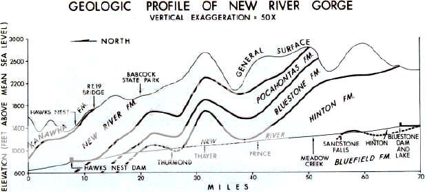
The rock sequences in the Gorge contain seven formations which can
be lumped together into two major groups; the four oldest being of
Mississippian age (the Mauch Chunk Group). The formations in this
group are the Bluestone Formation which consists of shale and
siltstone with lesser sandstone and limestone. Its maximum
thickness is 650 feet. The Princeton Formation is a distinctive
60-foot thick coarse conglomerate that grades into a sandstone. The
Hinton Formation consists of marine and freshwater shales and
siltstones with lesser amounts of sandstone and limestone and it's
maximum thickness is 1,100 feet in Gorge. Finally is the Bluefield
Formation which consists mostly of marine calcareous shales with
minor limestone, siltstone, and sandstone. Its maximum thickness is
25 feet in the Gorge.
The three youngest of Pennsylvanian age (the Pottsville Group) will
now be listed. This group consists of the Kanawha Formation, which
consists of 900 feet of shale and siltstone with lesser amounts of
sandstone. The New River Formation consists of coal-bearing
sandstones, siltstones, and shales. It contains Fire Creek,
Beckley, and Sewell coal seams and Nuttall sandstone at top.
Maximum thickness of this formation is 900 feet. The Pocahontas
Formation consists of coal-bearing sandstone with lesser amounts of
siltstone and shale. It has a maximum thickness of 400 feet. This
younger Pennsylvanian Group is distinctive because it is the oldest
one containing commercial coal beds in West Virginia.
The rocks were originally deposited horizontally as sediments in
water bodies and swamps, but today they dip to the northwest at
about 60 feet per mile due to subsequent tilting by
mountain-building forces that affected all the Appalachians. The
geologist can measure the true thickness of each layer, and by
adding them together can obtain a total thickness of about 4,000
feet. This is not to be confused with the maximum depth of the
Gorge, which is about 1,600 feet. The rock sequence is much thicker
because the layers are tilted.
In order to claim
this earthcache, please send me an email with the answers to the
following questions:
1. What is the name of the only river to cut through the
Appalachian Plateau?
2. In what direction does this river flow?
3. Explain how the gorge was/is being formed.
4. What industry was greatly influenced by the forming of this
gorge?
5. What is the approximate length of the gorge?
6. According to the diagram, what formation are you standing
on?
7. How many vertical boards make up the walkway of the Fern Creek
bridge?
PLEASE USE CAUTION WHEN ACCESSING THIS OVERLOOK. MANY SHEER
CLIFFS ARE PRESENT WHICH MAY BE AWESOME FOR ROCK CLIMBERS BUT
DEADLY TO GEOCACHERS! I have added a star for the terrain to
account for these cliffs.
A very special
thanks goes to the National Park Service for their cooperation in
allowing this Earth Cache to be placed inside the Park
boundaries!
Sources:
WV Geological Survey 1
WV Geological Survey 2
National Park Service 1
National Park Service 2
Additional Hints
(No hints available.)