Beträffande åsgravarnas bildning finns ett flertal teorier. En
teori (Haldén 1936) bygger på att de uppstått genom erosion av
framrusande smältvatten. En annan att de har bildats då stora
isblock brutits loss från ismassan vid avsmältningskanten längs
istunneln. En förutsättning för detta är att istäcket var relativt
tunt vid avsmältningen. Dessa isblock ska sedan likt
dödisgropsbildningen bäddas in i material och sedan smält. En
tredje teori (C-G Wenner 1974) bygger på att smältvatten avbördats
på den is som tryckte ner den djupaste delen av dalen. Sediment ska
sedan ha överlagrat remsor av landis på sidan av isälvens
huvudfåra. Dessa ribbor blev sedan liggande begravda i sediment
tills de smälte och åsgravarna uppstod. Detta åskådliggörs i
figuren.
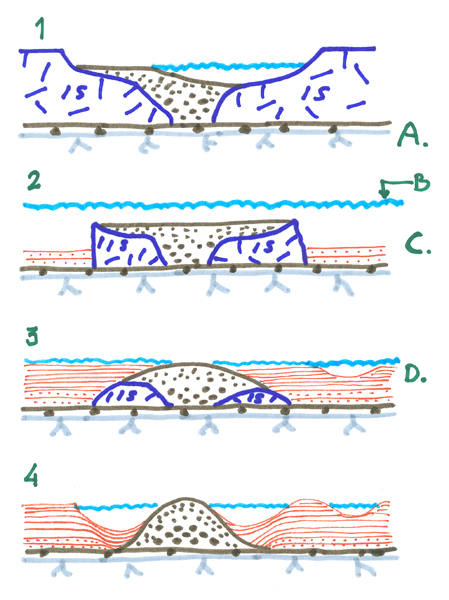
- Isälven har skapat en bred fåra på landisen. (A.
Morän-Berggrund)
- Då isen smält blir sedimenttäckt is kvar ( B. Vattenyta, C.
Äldre sediment)
- Issjön har fyllts av sediment. (D. Yngre sediment)
- Isen smälter och åsgravar har uppstått.( Här ses två åsgravar
på respektive sida om åsen och till höger en å)
För att
logga
- Mät upp avståndet med t ex din GPS västlig-ostlig ledd mellan
stigarna runt åsgraven.
- Gör samma sak i nordlig - sydlig ledd och maila mig
svaren.
- Skicka gärna in ett trevlig foto med åsgraven med t ex din GPS
i bild. (Frivilligt)
Är måtten fel tar jag kontakt så logga under tiden
English
South from the farm area on Rostockaholme is a swamp, what
before who believed was the farm's fishpond. Drillings in the swamp
shows however, that the hollow is quite naturally arisen through
that a big ice block lain left long at ice melting and prevented
marketing of grits and concrete, a so called ridge grave or ridge
hole.
How the ridge graves' was created is there a majority theories
about. One theory (Haldén 1936) builds on that they arisen through
erosion of Gushed melt water. Another that they have been formed
when big ice block been broken loose from the ice mass at the edge
of melting ice along the ice tunnel. A presuppose for this is that
the ice blanket where relatively thin then the ice melting. These
ice blocks will later been embedded in materials and after that
melted. A third theory (C-G Wenner 1974) builds on that melting
water unburden on that ice that pressed down the deepest part of
the valley. Sediment will since have overlaid strips of ice on the
side of the ice river's central groove. These strips became since
lying buried in sediment until they melted and the ridge graves
arose. This you can see in the figure.
- The ice river have made a furrow on the ice.(A.
moraine-bedrock)
- When the ice have melted away, there be sedimented ice lefted (
B. Waterline, C. Older sediment)
- Icelake have been filled up with sediment. (D. Younger
sediment)
- The ice have melted and ridgegraves have araisent.( Here is two
ridge graves on each side of the ridge and a river on their
right)
To log
this
- Measure the distance on the lane around the ridge grave ( east
- west), maybe with you GPS.
- Do the same for the direction north- south and mail me the
answers.
- Take a photo of the ridge grave with example yor GPS in.
(Optional)
If the distance is wrong I contact you. Log it till then.