(C) ropiky.net
SK:
V rokoch 1935-1938 prebehlo budovanie najrozsiahlejsej a najnakladnejsej stavby v historii prvej ceskoslovenskej republiky. Tisice objektov opevnenia bolo vybudovanych v pohranicnych oblastiach ako obrana proti hrozbe zo strany nacistickeho Nemecka, ale aj inych susednych statov, s ktorymi mala republika napate vztahy. Do roku 1951 bolo planovane opevnit celu hranicu, okrem 200 km useku hranice s Rumunskom, ktore bolo povazovane za spojenca. Okrem toho mali byt opevnene aj strategicke vnutrozemske priecky. Vystavba vsak bola nahle ukoncena v septembri 1938 po podpisani Mnichovskej zmluvy.
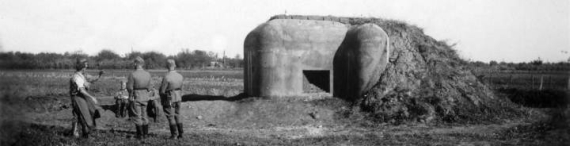
Opevnenie bolo budovane podla vzoru francuzskej Maginotovej linie. Pozostavalo z tazkych a lahkych objektov. Tazke objekty zahrnali pechotne zruby a delostrelecke pevnosti. Lahke opevnenie tvorili primarne standardizovane pevnostky zname ako ropiky. Ropiky boli stavane v bojovych liniach, vyuzivajucich system bocnych, vzajomne sa prekryvajucich palieb. Zo strany nepriatela bol objekt zasypany zeminou a nebola odkryta ziadna strielna. Priestor medzi objektami opevnenia bol vyplneny prekazkami.
Povodny rozpocet na vystavbu opevnenia bol 10,9 mld korun ceskoslovenskych. Z tejto sumy sa do ukoncenia vystavby stihla preinvestovat asi stvrtina. Po ukonceni vystavby ostali rozostavane useky v roznom stave. Na slovensko-madarskej hranici boli v tom case v dokoncenom alebo takmer dokoncenom stave stovky ropikov.
Nasledkom Mnichovskej zmluvy a po nej nasledujucej Viedenskej arbitraze v novembri 1938 sa velka vacsina slovenskych obrannych linii ocitla na madarskom uzemi. V nasledujucich mesiacoch madarska armada velmi dokladne zlikvidovala takmer vsetky dosial postavene objekty. Dovodom bola jednak likvidacia obrannej linie, ale aj riesenie akutneho nedostatku stavebneho a vyrobneho materialu vo vojnovych casoch. Zelezobeton pevnostok bol vytazeny, pricom betonova drt isla na stavbu ciest a ocelove vystuze na vyrobu zbrani. Dnes na miestach byvalych ropikov zostavaju len stopy vo forme kratera, nasypu, drobnych kuskov betonu, pripadne su zvysky uplne zahladene (standardne na obrabanych poliach).
Tych niekolko desiatok ropikov, ktore zostali na uzemi Ceskoslovenska, resp. neskor Slovenskeho statu, stihol o nieco lepsi osud. Na vychodnom Slovensku sa cast linie zachovala prakticky v povodnom stave. Rovnako na zapadnom Slovensku sa takmer neporusena zachovala obranna linia rieky Moravy a bratislavskeho predmostia. Na strednom Slovensku bola linia znicena koncom vojny ustupujucou nemeckou armadou, avsak demolacia prebehla objekt od objektu s roznou intenzitou a material nebol odstraneny. K ruinam, ktore zostali do dnesnej doby, vas privedu stages tejto kesky.
Trasa vedie cez 20 byvalych stanovist ropikov. Prva stage je ukazkou, ako dopadli objekty zlikvidovane madarskou armadou - prilahlou cestickou pravdepodobne prechadzala hranica vytycena Viedenskou arbitrazou. Ostatne stages su objekty v roznom stadiu demolacie nemeckou armadou, pripadne v neskorsom obdobi polnohospodarmi. Na kazdej stage treba najst cervenou farbou napisane trojciferne cislo. Cislo sa nachadza vzdy na betone prisluchajucom zdemolovanemu ropiku, ale nemusi to byt presne na suradniciach stage. Oznacme si cisla pre stage1-20 pismenami A-T (podla anglickej abecedy).
Final
Skuska spravnosti:
A+B+C+D+E+F+G+H+I+J+K+L+M+N+O+P+Q+R+S+T = 10622
Finalne koordinaty:
UVW = A + B + C + D - E - F - G + 167
XYZ = H + I + J + K + L + M + N + O - P - Q - R - S - T - 68
N 48° 16.UVW
E 019° 31.XYZ
Vypocet pre Excel
Nebudem vas hyckat ziadnymi pomocnymi waypointami, mapovu pripravu a zvladnutie terenu nechavam na kazdom hladacovi. Parkovanie je ale o nieco jednoduchsie v blizkosti stage20 nez v blizkosti stage1. A nebojte sa zobrat aj deti, teren nikde nie je vyslovene nebezpecny a na konci caka celkom velka finalovka. Vydolovat finalovku je vyzva sama osebe, je privalena troma kamenmi, z ktory obzvlast jeden je riadne tazky. Prosim vratte ju nazad tak ako bola, poriadne zastrcit pod koren a privalit spominanymi kamenmi. Miestne diviaky su velmi aktivne (a silne).
Zdroje: ropiky.net, mapa.opevneni.cz
Datum poslednej zmeny: 12. novembra 2010
EN:
In the years 1935 to 1938, Czechoslovakia was building a massive fortification of its borders. Thousands of forts were built against the threats from Nazi Germany, but also from other neighboring states. It was planned to build the whole line of border fortification until 1951, with the exception of 200 km border segment with Romania. Moreover, the strategic inland lines should have been fortified, too. The construction was canceled in september 1938, as a result of the Munich Treaty.
The munition was inspired by the French Maginot line. It consisted of light and heavy objects. The light fortification mainly consisted of a line of small infantry forts, nicknamed "ropik". Their embrasures were oriented along the line, so that the lines of fire of neigboring objects were overlapping. From the enemy's side, the forts were smothered by soil. The areas between neighboring objects were blocked by obstacles.
The budget of the complete munition was planned to be 10.9 billion Czechoslovak crowns. Until the end of the construction, about 25% of this amount was actually spent. After the construction stopped, the half-built forts remained in different states of completion. On the Slovak-Hungarian border, hundreds of objects were completed or nearly completed.
Following the Munich Treaty and the consequent Vienna Award in november 1938, the vast majority of Slovak border defenses fell into Hungarian dominion. In the following months, the Hungarian army very carefully destroyed almost all of the forts. Besides destroying the defense line, the goal was also to ease the war-time shortage of building and manufacturing material. The crushed concrete was used for road building, while the steel reinforcements were used for weapon manufacture. Today, all that remains is a crater, an embankment, a few small concrete pieces, or the object is completely extinguished (usually in the fields).
Some sections of the fortification lines remained in the Czechoslovak and later Slovak area. In the eastern Slovakia, a part of the defense line is preserved until today. In the western Slovakia, the defenses of river Morava and the bridgehead of Bratislava are also quite well preserved. In the central Slovakia, the objects were demolished nearing the end of the war by the retreating German army. However, the quality of the demolition varied and the ruins were not extinguished. The stages of this cache will show you some of the remaining ruins.
The route will lead you through 20 former ropik posts. The first stage will show you an object thoroughly demolished by the Hungarian army. The neighboring road was probably a part of the war-time borderline. The remaining stages show the objects in various states of destruction by the German army. At each stage, you have to find a three-digit number painted in red. The number is painted on concrete belonging to the former fort, but doesn't have to be precisely on the stage's coordinates. Now for each number at stage1-20, assign the letters A-T, respectively (English alphabet).
Final
Check the clues:
A+B+C+D+E+F+G+H+I+J+K+L+M+N+O+P+Q+R+S+T = 10622
Final coordinates:
UVW = A + B + C + D - E - F - G + 167
XYZ = H + I + J + K + L + M + N + O - P - Q - R - S - T - 68
N 48° 16.UVW
E 019° 31.XYZ
Excel sheet
There are no additional waypoints, the map preparation and terrain crossing is up to you. However, car parking is easier near stage20 than near stage1. Don't be afraid to bring your children, the terrain is not dangerous and the final box is quite large. Uncovering the final is a special challenge, for it's covered by three large stones. One of them is especially heavy. Please return the box to its original place, stuck firmly under the root and covered by the boulders. The local wild boars are very active (and strong).
References: ropiky.net, mapa.opevneni.cz
Last modification date: 12 November 2010