Dixie Caverns was discovered relatively recently compared to other karst formations in the Blue Ridge Mountains. It was stumbled upon in 1920, cleaned out, and opened to the public in 1923, albeit through a much smaller entrance than now and without electric lights. Excavated remains from the cave entrance attest to Native Americans utilization of the cave for food storage and shelter long before its “discovery”.
Cave Formation
All caves are not created equal - in fact no two are exactly alike. There are different kinds (ice, karst, volcanic tubes, sea caves) and they are formed by many different processes (chemical, erosion, wave action, subsidence, dissolution, lava floes). No one is able to accurately predict how long it takes a cave to form. There are just too many variables, and often these are unobservable since they are underground. Forces such as streams, wind, lava, acid rain or ocean waves over time can carve out spaces large enough for us to walk in. Dixie Caverns was formed by water flowing through an area of soluble rock.

The Appalachians
The Roanoke Valley is located in a band of geology which spans the western third of the Commonwealth called the Blue Ridge Mountain Province. This physiographic Province is part of the Appalachian Mountain range and extends from Pennsylvania to Georgia. The Blue Ridge contains the highest mountains in eastern North America. The three primary rock types in this Province are limestone, dolomite and shale.
There are few surface streams in the limestone valleys of the Blue Ridge Province as runoff from mountain slopes disappears into the subsurface upon contact with the karst bedrock. Water then flows underground, emerging at springs on the valley floor. So what in the world does "karst" mean?
Karst Topography
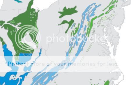
Not all bedrock is solid. Karst is a German word derived from the Slovenian "Kras" which means bare, stony ground. It was originally used to describe a limestone plateau near Trieste, Slovenia. Now the term means any landscape with distinctive landforms and hydrology shaped by the dissolution of a layer or layers of soluble bedrock, usually carbonate rock such as limestone (calcium carbonate, CaCO3) or dolomite (calcium magnesium carbonate, CaMg(CO3)2). Both of these rock types are slightly soluble in water. Karst terrain is characterized by springs, caves, sinkholes, and aquifers that are highly productive but also vulnerable to contamination. About 20 percent of the land surface in the U.S. is classified as karst. Other parts of the world with large areas of karst include China, Europe, the Caribbean, and Australia.
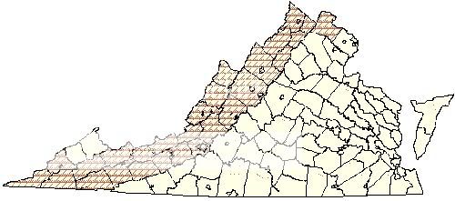
Virginia Counties with Karst Topography
 Some karst formations (called speleothems) can be the very dramatic stalactites, stalagmites, drapery, straws and flowstone that are showcased in this and other publicly accessible cavern systems along Interstate 81. Most caves are formed in limestone karst.
Common speleothems
Some karst formations (called speleothems) can be the very dramatic stalactites, stalagmites, drapery, straws and flowstone that are showcased in this and other publicly accessible cavern systems along Interstate 81. Most caves are formed in limestone karst.
Common speleothems

The Process
This is a dissolution cavern system. Rain can collect carbon dioxide as it falls to the earth forming a weak carbonic acid (acid rain). The addition of carbon dioxide greatly increases the solubility of the water. Once rain has been absorbed by the soil it picks up additional carbon dioxide from decaying organic matter and plants. In this way the water passing through the soil and into the underlying rocks has the capacity to dissolve limestone and dolomite. The ground water enters cracks and fractures in these layered rocks and begins to dissolve it. When the water reaches an underlying layer of impenetrable rock, the water moves sideways, forming an underground river.
Subterranean water follows difficult to predict paths, bearing little relationship to surface topography. Depending on the acidity of the water and the path it takes through the rock, a cave may form. If it finds an exit from the rock, this is called a spring. Most karst groundwater returns to the surface at springs near streams and rivers.
The Caverns are a public show cave requiring a fee for admission to the 45 minute guided tour. As of date of posting: Adults $12, Children (5-12) $6. Summer hours June 1-Oct. 15 9:30-6. Winter hours Oct. 16-May 31 9:30-5.
To log this Earthcache as a find, please answer the following:
1. Who made the modern discovery of the cave?
2. What kind of stone forms the structure of the cave?
3. What type of formation is the “wedding bell”?
4. What type of formation is the “back scratcher”?
5. What type of formation is “bugs bunny’s castle”?
6. What type of formation is the “nacho“, or “dorito” (or sometimes "cave bacon")?
7. Why did the cavern workers bring their own water when there is a natural spring here?
8. Name two animals indigenous to the caverns.
9. Take a photo of yourself and/or your GPS in front of your favorite formation in the cavern.
E-mail the answers to me and post the photo (Item 9) with your log. Do not log as a find until you have a photo ready to post. Failure to comply with these requirements will result in log deletion.


Sources:
USGS Virginia Karst Project
Virginia Cave Board
Virginia Department of Conservation and Recreation
Ask.com