Ettringer Wand (mit Zufluchtshöhlen) EarthCache
Ettringer Wand (mit Zufluchtshöhlen)
-
Difficulty:
-

-
Terrain:
-
Size:  (not chosen)
Please note Use of geocaching.com services is subject to the terms and conditions
in our disclaimer.

Achtung: Ihr befindet Euch in einem Naturschutzgebiet (Hochstein). Die offiziellen Wege und der Parkplatzbereich müssen zu keiner Zeit verlassen werden, verhaltet Euch umsichtig.
VORSICHT: einige Stellen der Wand sind nicht stabil. Nähert Euch nur niedrigen Teilen ohne Abbruchgefahr, betretet die Höhlen nicht.
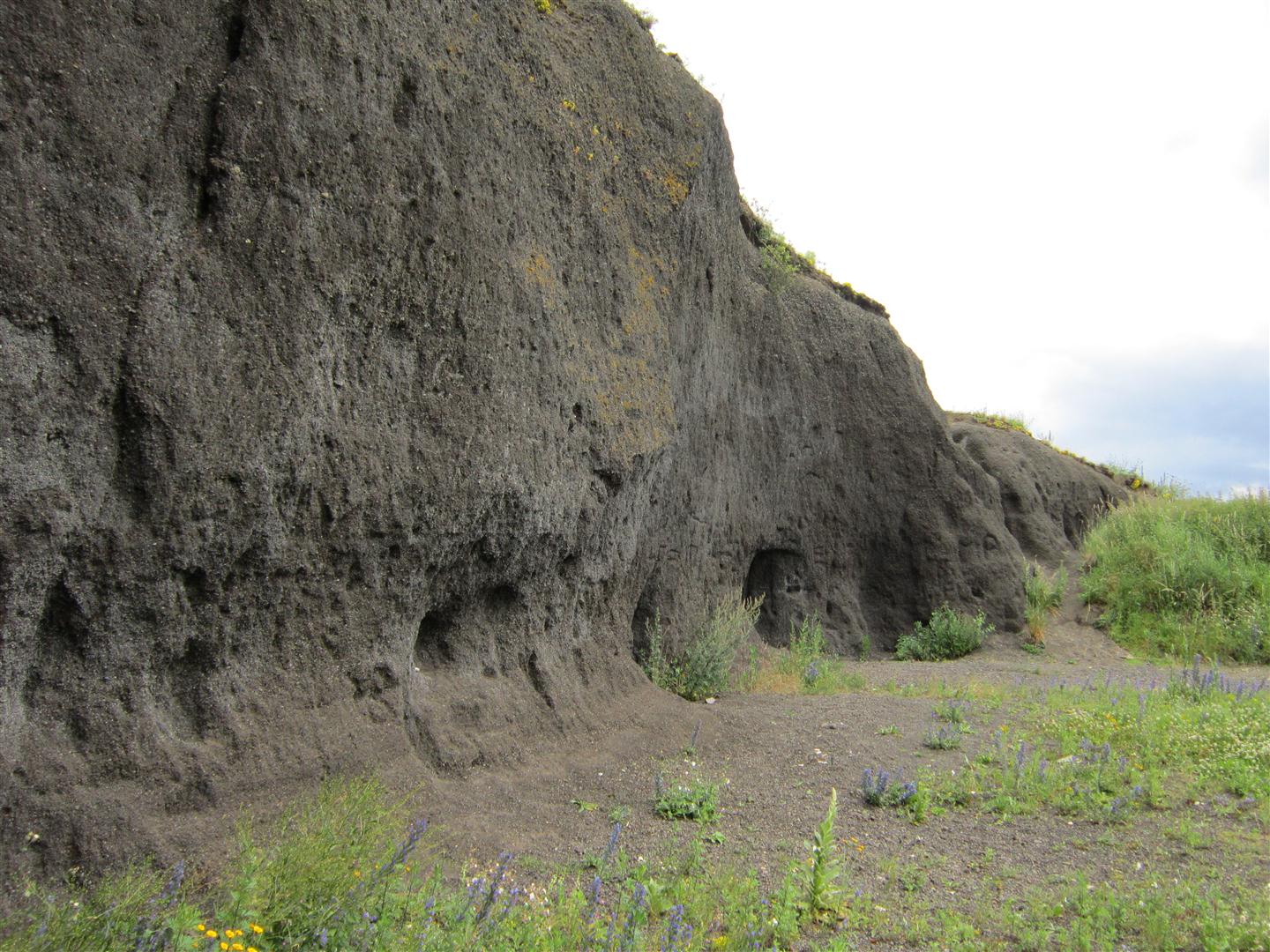
Dieser Earth-Cache führt Euch zu einem eher unbekannten Vulkanaufschluss in der Maria Laach Region: Der schwarzen Ettringer Wand samt den Zufluchtshöhlen.
Direkt am Parkplatz ist ein Einstiegpunkt für einen der offiziellen Eifel-Traumpfade. Vor knapp 13.000 Jahren war es hier dagegen wesentlich weniger traumhaft. Im Bereich des heutigen Laacher Sees (knapp 5 km von der Ettringer Wand entfernt) gelangt Wasser in eine riesige unterirdische Magmakammer, der schlagartig gebildete Wasserdampf sprengt den Deckel der Kammer ab (diese Art von Ausbruch nennt man übrigens Plinianische Eruption) und in einer gewaltigen, über 10 Tage anhaltenden Ausbruchsserie wird die Umgebung mit riesige Mengen Bims und Asche bedeckt.
Wenn Ihr vor dem knapp 7 Meter hohen Ettringer Bodenaufschluss steht, seht Ihr nur ist ein Teil dieser enormen Auswurfmassen, die Fallablagerungen können stellenweise eine Höhe von 50 Metern erreichen. Die Fallablagerungen sind hier in Ettringen locker und sehr homogen geschichtet, ohne Anzeichen pyroklastischer Ströme. Die Bimssteinchen sind klein und schwärzlich, im Gegensatz zu anderen Aufschlüssen in der Region, die eher grosse und helle Bimssteine zeigen, wie z.B. die sehr helle Wingertsbergwand:
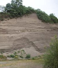
Wingertsbergwand: helles Material.
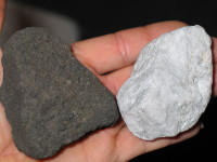
Die Farbe spricht dafür, dass der Bims aus basaltischer Lava mit recht wenig Lufeinschlüssen stammt, mit zunehmendem Luftgehalt und abnehmender Blasengröße wird die Farbe von Bims heller.
Die Ettringer Wand ist ausserdem besonders interessant, da hier deutlich wird, wie Menschen die Produkte vulkanischer Grossereignisse nutzen. Ein Materialabtrag ist fast ohne Werkzeuge möglich ist, mit den blossen Fingern können schnell Löcher gebohrt werden, diese Eigenschaften machten sich die Bevölkerung der umliegenden Städtchen im zweiten Weltkrieg zunutze und legten eine Reihe von sogenannten Zufluchtshöhlen an. Diese Höhlen sind auch heute noch erhalten.
Am Ende eines sonnigen Tages könnt Ihr eine weitere tolle Eigenschaft von Bimssteinen live erleben: die Wand hat eine enorme Menge Wärme gespeichert (die Lage ist dafür perfekt: Berg, kein Schatten, Sonnenseite) und strahlt diese nun ab, wenn Ihr langsam darauf zu geht, merkt Ihr das bereits aus einigen Metern Entfernung. Legt man die Hand auf die Wand, wird klar, warum Bims bei der Herstellung von dämmenden Baumaterialien eingesetzt wird, die Steinchen sind mächtig warm, Bims hat besondere thermische Eigenschaften. In einigen der geschützten Höhlungen fühlen dementsprechend auch Pflanzen (Farne) wohl.
Log-Aufgabe:
Eure Aufgaben drehen sich um diese thermischen bzw. isolierenden Eigenschaften von Bims.
1. messt die Lufttemperatur Parkplatzmitte (weg von der Wand)
2. messt anschliessend dann entweder die Temperatur der äusseren Bims-Schichten der Ettringer Wand (Thermometer in eine der grossporigen Öffnungen stecken, sucht Euch eine stabile und sichere Stelle, überhängende Teile der Wand können abrutschen!) oder die Innentemperatur im Eingangsbereich einer der Höhlen (Höhlen nicht betreten, Pfade bzw. Parkplatzbereich nicht verlasen).
3. Wie erklärt Ihr Euch, dass die Ettringer Wand nach einem sonnigen Tag wesentlich mehr Wärme als die Wingertsbergwand abstrahlt (anderer Grund als Berglage)?
Die Messwerte, die Temperaturdifferenz (Luft/Wand) sowie die Antwort dann bitte mailen.
Fotos sind wie immer willkommen, aber natürlich keine Pflicht...
Bitte einen Beutel für Müll mitnehmen, leider schmeissen viele Dummies Dosen etc. im Wandbereich weg.

You are in a nature reserve, do not leave the pathes or parking area.
This EarthCache is meant to show you a rather unknown volcanic outcrop in the Maria Laach region: the black Ettringer Wand (Ettringer wall) with man-made shelter-caves (Ettringer Zufluchtshöhlen).
Nearby you will find the Vulkan- Eifel-Traumpfad ("Dreampath") .
Approximately13.000 years ago the setting in this area was much less dreamlike. 5 kilometers north-east of your location a giant underground magma chamber made contact with groundwater. The water vapour violently blew of the magma chamber's cover (a so called Pliniani eruption) and for the next 10 days a sequence of eruptions covered the land with huge amounts of ashes and pumice.
Standing in front of the Ettringer wall (height: ca. 7 Meters) you just see the topmost layer of the enormous amounts of volcanic deposits, some areas around Maria Laach are covered with more than 50 meters of material. In Ettringen the fall deposits are rather lose and layered homogeneously, the pumice is small and black, in contrast to other outcrop in the region with larger and brighter pumice, e.g. the famous Wingertsbergwand:
Wingertsbergwand: brighter pumice, traces of fast transport (flow).
The dark color might indicate that the pumice is of basaltic composition with rather few bubbles (usually more air bubbles lead to brighter pumice). In contrast to the Wingertsbergwand, there are no signs of pyroclastic flow.
Apart from the unusual black color, the Ettringer Wand offers another unique feature: you can see an example for how man makes use of volcanic material. It is very easy (even without tools) to drill cavities into the pumice layers, in the second world war, the population of the nearby villages made use of this feature to dig several shelter caves into the wall. These caves are still in rather good condition.
At the end of a sunny day you can witness another great feature of pumice : during daytime the little bubble-filled stones in the black wall have stored lots of heat, if you stretch out your arms and approach the wall from the parking area, you will feel lots of heat radiation. If you finally touch the wall, it is really hot and you will realize, why pumice is widely used to make insulative low-density building material. This wall is really perfect for demonstrating the heat storing abilities of pumice (also the outcrop loaction is ideal, e.g. mountain top, facing the sun nearly all day) .
Your task for the log:
Now you test the heat-storing / insulating abilities of pumice.
1. please measure the temperature at the parking area
2. then take a temperature reading of the wall (stick the thermometer into a little hole, but please do not step into dangerous areas, pick a safe place, e.g. lower part of the wall) or measure the temperature in the entrance area of one of the caves. Do not enter the caves.
3. What is your explaination for the fact that after a sunny day the Ettringer Wand has a lot more heat radiation than the Wingertsbergwand?
To get the log clearance, please email the temperature readings, calculate the difference between outside and wall temperature and the answer to the Ettringer Wand - Wingertsbergwand question.
Pictures are welcome, but not needed to log.
Do not drill holes into the wall.
Do not enter the caves
Do not leave the parking area or the official paths.
Please remove some garbage from the caves' entrances.
Additional Hints
(No hints available.)