 For 100 years, the National Park Service has preserved America’s special places “for the enjoyment, education, and inspiration of this and future generations.” Celebrate its second century with the Find Your Park GeoTour that launched April 2016 and explore these geocaches placed for you by National Park Service Rangers and their partners.
geocaching.com/play/geotours/findyourpark


Come on a journey to remember and commemorate the history and travels of Captain John Smith!
Over four hundred years ago, Englishman John Smith and a small crew set out in an open boat to explore the Chesapeake Bay. Between 1607 and 1609 Smith mapped and documented nearly 3,000 miles of the Bay and its rivers. Along the way he visited many thriving American Indians communities and gathered information about this “fruitful and delightsome land.” In December 2006 the U.S. Congress designated the routes of Smith’s explorations of the Chesapeake as a national historic trail—the first national water trail.
Are you ready to follow in the wake of Captain John Smith? Visit sites along the National Historic Trail and learn about the native cultures and the natural environment of the 17th-century Chesapeake through the Captain John Smith Chesapeake Geotrail. The Trail provides opportunities for you to experience the Bay through the routes and places associated with Smith’s explorations. Caches will be located in museums, refuges, parks, and towns in Virginia, Maryland and Delaware along the rivers and creeks that Smith and his crew explored four centuries ago.
The Captain John Smith (CJS) Geotrail launched June 4, 2011 with over 40 caches within Maryland, Virginia and Delaware. A trackable geo coin will be awarded to the first 400 geocachers, while supplies last, for locating at least 15 CJS caches. To be eligible for the coin, geocachers must download a passport from either the CJS Geotrail or Maryland Geocaching Society website. Geocachers must find and log at least 15 finds, record the code word from each cache on their passport and post a picture of themselve at each cache location. After discovering the 15 required caches, geocachers may have thier passports validated in person or via mail at the National Park Service, Chesapeake Bay Office located at 410 Severn Ave, Suite 314, Annapolis, MD 21403. Please refer to the passport for complete validation instructions.
Participating in the CJS geotrail is fun and we hope that many people join in. However, it is not a requirement for logging your find on this cache once you find the container.
Welcome to the Thomas Stone National Historic Site!
This facility is free of charge, and is open during the winter: 9-5 Wednesday-Sunday (Labor Day - Memorial Day)
Summer Hours: Open 9-5 Daily (Memorial Day - Labor Day)
Closed: Thanksgiving, December 25 and January 1
Please NO NIGHT CACHING and adhere to all National Park Service rules!
You are seeking a two stage puzzle multi cache. At the posted coordinates, N 38° 31.807’ W 077° 02.271’. You will find a cemetery where you will obtain information needed for the final cordinates.
Final N 38° 3A.BCD W077° 0W.XYZ
A= 3rd digit in the year of death of Margaret Graham. B= Last digit in the year Margaret Graham was born. C=3rd digit in the year of Thomas Stone’s birth. D=3rd digit in the year Sarah Ann Caroline was born.
W=Last digit in the year in which William Briscoe Stone died. X=Last digit in the year in which Thomas Stone was born. Y=Last digit of the year on the Sons of the American Revolution (SAR) standard (not the life span of Thomas Stone). Z=Sum of the two digits of the day Sarah Ann Caroline was born.
The final is a Lock & Lock container stocked with CJS and Thomas Stone Historic Site swag.
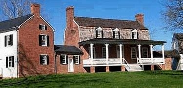
The Thomas Stone National Historic Site is located about 25 miles south of Washington D.C. in Charles County, Maryland in the town of Port Tobacco. The site was established to protect the home and property of Thomas Stone, one of the 56 signers of the United States Declaration of Independence. Today it is managed by the National Park Service. Ranger-Led tours of Haberdeventure, Thomas Stone's home, are available until 4pm each day. Visitors are also welcome to experience the park at their own pace to stroll across the park grounds amidst the farm buildings or travel old farm trace roads and imagine the past.
Stone came from a long line of public servants. His great-great grandfather, William came to America from England in 1628 and settled first in Virginia. Twenty years later with England engaged in a bloody civil war, William Stone was chosen by Maryland's proprietary leader, Lord Baltimore, to be the governor of Maryland, the first Protestant to hold that office in the colony. His tenure was filled with conflict, the Puritans of the colony not in line with his tolerant views toward other Christians, namely Catholics. But Stone survived and was granted acreage in newly formed Charles County, Maryland in 1658 which would establish the Stone line that has lasted until the present. Two of Thomas' great-grandfathers served in the Maryland Assembly and in Thomas' era, his brother John would be a three-term governor of the state, while his brother Michael served as a representative in the 1st Congress of the United States in 1789.

Stone was elected to Congress in 1775 and served on the committee that framed the Articles of Confederation. He voted for Independence in 1776, and signed the Declaration. He was elected to Congress again in 1783 and served as chairman, but retired at the end of his term. He was elected to attend the Constitutional Convention in 1787, but declined the office because of his wife's failing health. As her condition declined, he withdrew more from public life. When she eventually succumbed to illness in 1787, Stone became depressed and died less than four months later in Alexandria, Virginia reportedly of a "broken heart".
Thomas Stone lived more than a century after Captain John Smith and his crew explored the Potomac River region. When Smith arrived in the summer of 1608, the area was heavily forested, and populated by a many groups of native peoples, including the Potapaco who lived along the Port Tobacco River in Charles County. The Potomac’s land were rich in both natural game and wild foods as well as home to fertile soil in some locations – usually the places where American Indians chose to locate their towns. Under the authority of the tayac, or the supreme chief of the Piscataway nation, the Potapaco [as Smith recorded their name] occupied three towns and numbered roughly 140 people with 30 warriors. In the 1650s, the Potapaco left Maryland for Virginia, ultimately settling along the Rappahannock River.

Thanks to Moonpie10 for helping with this hide and to the Maryland Geocaching Society for assisting with this project.