

Come on a journey to remember and commemorate the history and
travels of Captain John
Smith!
Over four
hundred years ago, Englishman John Smith and a small crew set out
in an open boat to explore the Chesapeake Bay. Between 1607 and
1609 Smith mapped and documented nearly 3,000 miles of the Bay and
its rivers. Along the way he visited many thriving American Indians
communities and gathered information about this “fruitful and
delightsome land.” In December 2006 the U.S. Congress
designated the routes of Smith’s explorations of the
Chesapeake as a national historic trail—the first national
water trail.
Are you ready
to follow in the wake of Captain John Smith? Visit sites along the
National Historic Trail and learn about the native cultures and the
natural environment of the 17th-century Chesapeake through the
Captain John Smith Chesapeake Geotrail. The Trail provides
opportunities for you to experience the Bay through the routes and
places associated with Smith’s explorations. Caches will be
located in museums, refuges, parks, and towns in Virginia, Maryland
and Delaware along the rivers and creeks that Smith and his crew
explored four centuries
ago.
The Captain John Smith (CJS) Geotrail launched June 4, 2011 with
over 40 caches within Maryland, Virginia and Delaware. A trackable
geo coin will be awarded to the first 400 geocachers, while
supplies last, for locating at least 15 CJS caches. To be eligible
for the coin, geocachers must download a passport from either the
CJS Geotrail or Maryland Geocaching Society website.
Geocachers must find and log at least 15 finds, record the code
word from each cache on their passport and post a picture of
themselve at each cache location. After discovering the 15 required
caches, geocachers may have thier passports validated in person or
via mail at the National Park Service, Chesapeake Bay Office
located at 410 Severn Ave, Suite 314, Annapolis, MD 21403. Please
refer to the passport for complete validation instructions.
Participating in the CJS geotrail is fun and we hope that many
people join in. However, it is not a requirement for logging your
find on this cache once you find the container.
You are seeking a traditional hide. A Lock & Lock container
stocked with a variety of items. This site is only open dawn till
dusk. Please no night caching!
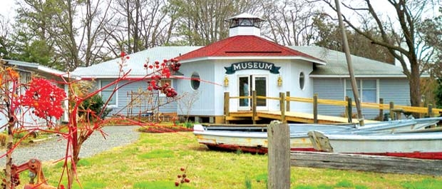
Located in Middlesex County on Mill Creek, just off the Chesapeake
Bay in the heart of Deltaville, Virginia, the Deltaville Maritime
Museum and the adjoining Holly Point Nature Park offer a unique
opportunity to enjoy the maritime history and culture of the
region. The museum has a long history interpreting and sharing the
story of Captain John Smith, and it is home to a replica of
Smith’s Discovery Barge or shallop. In addition, you can
explore a host of other Chesapeake Bay workboats, including the
newly restored F.D. Crockett, a nearly century old log buyboat
– a truly unique bay artifact. Both the museum and the park
are a place to study, to learn, and also to relax and enjoy the
tranquility of this area. Appropriately, the museum welcomes visits
by boat.
Deltaville Maritime Museum shares a strong geographic connection to
the Smith Trail. It is located on Stingray Point, which gained its
name from a harrowing encounter Smith had in the summer of 1608.
After spending a month exploring the Potomac River, Smith and his
crew turned their attention to the mouth of the Rappahannock -
where they promptly got stuck on a shoal. While waiting for the
tide to shift and float the boat free, the men decided to fish the
surrounding waters by impaling the unfortunate animals on their
swords. Smith had the misfortune to spear a cow-nose ray, which
sank its tail spine into his wrist as he tried to remove it from
his sword. The effects of the slimy toxin caused his arm and chest
to swell so severely that he began to order preparations for his
burial, including the digging of a grave. However, Dr. Russell, the
ship’s physician, applied a “precious oyle,” and
by evening Smith had recovered enough to enjoy the stingray for
dinner. He promptly named the land, “Stingray Ile,”
which survives today at Stingray Point.
To learn more about Stingray Point, in the 17th century and today,
visitors can call 1-877-BUOY BAY, or visit Buoy Bay for a historical
summary as well as near-real-time data on the weather and water
conditions.

Thanks to Pud & Pop for helping with this hide and to the
Maryland Geocaching Society for assisting with this
project!