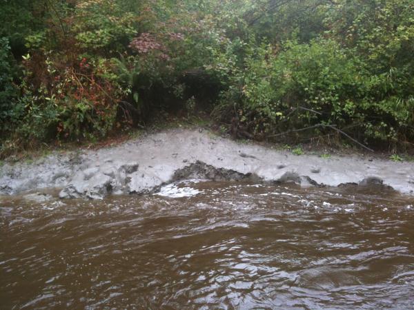
Clay deposits such as this can be found on many of the small rivers throughout the Fraser Valley. It is commonly assumed that the clay in the river banks has been deposited by that same river, but it is the erosion by the river that is actually exposing this more ancient deposit. This small river is actually much too "young" and fast to have made such a deposit.
Clay is a naturally occurring material composed primarily of fine-grained minerals. Clay deposits are mostly composed of clay minerals, a subtype of phyllosilicate minerals, which impart plasticity and harden when fired or dried; they also may contain variable amounts of water trapped in the mineral structure by polar attraction. Organic materials which do not impart plasticity may also be a part of clay deposits.
Clay minerals are typically formed over long periods of time by the gradual chemical weathering of rocks, usually silicate-bearing, by low concentrations of carbonic acid and other diluted solvents. These solvents, usually acidic, migrate through the weathering rock after leaching through upper weathered layers. In addition to the weathering process, some clay minerals are formed by hydrothermal activity. Clay deposits may be formed in place as residual deposits in soil, but thick deposits usually are formed as the result of a secondary sedimentary deposition process after they have been eroded and transported from their original location of formation. Clay deposits are typically associated with very low energy depositional environments such as large lakes and marine deposits.
Silt, clay, and loam (mixed clay, silt, and sand) are common on the Fraser River floodplain (areas below an elevation of 15 m). These sediments were deposited over thousands of years by seasonal floodwaters that spread across these lowlands.
Ice Age sediments deposited during the Pleistocene Epoch (2 million to 11,000 years ago) underlie the gently rolling uplands (15 to 250 m elevation) of the Fraser Valley. Most Ice Age sediments in the Vancouver area date to the last glaciation, about 25,000 to 11,000 years ago, and in particular to the period of glacier retreat when areas below 200 m elevation were covered by the sea. These sediments include till deposited directly by glaciers, gravel and sand laid down by streams flowing off the melting ice (outwash), marine clay and silt, and beach gravel and sand. Deposits older than the last glaciation are only exposed in steep escarpments along the margins of uplands.
In order to log this as a find you must email me the answers to the following questions.
1.) ***Grab a handful of this clay (in an undisturbed section) and squeeze it out through your hands. Can you see or feel any small rocks/sand/gravel or is it all just very fine material?*** Alternative question during high water times where it may be unsafe to retrieve a sample: estimate the length of clay deposit that is exposed along the riverbank. *** As of Sept 2022, there has been a sign on location asking to not play with the clay, Please use the alternate question for number 1. I have left the original there for historical purposes.
2.) Using the elevation reported on your GPSr tell me if you think the clay has been deposited by the Fraser River flooding or is this an ancient marine deposit, keeping in mind that the Fraser River floodplain is below 15 meters elevation, but the Pacific Ocean was once up to 200m elevation.
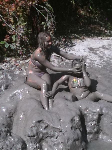
3.) Optional task: Post a picture of yourself, your GPS, or any sculpture you have made from this fun material. A picture from the site will confirm your find in the event that your answers to the other questions are incorrect.
As the trails to this cache are located within the park boundaries, I ask that you only visit the site within the parks posted open times of 9am-Dusk. Thanks for visiting and I hope you enjoyed getting dirty!!
 -->
-->