The Hydrologic Cycle

Water is constantly moving or cycling through the environment. This
movement of water as
atmospheric moisture, groundwater, and surface water is known as
the hydrologic cycle.
Groundwater
Groundwater is an essential component of the hydrologic cycle,
and hence of the natural heritage system. As groundwater moves
through one or more geologic layers, it can eventually discharge,
or seep out, into valleys, streams, lakes or wetlands. In this way,
groundwater provides the baseflow of many streams and can regulate
factors such as water quantity, quality, and temperature. It is
important to note that similar to surface water, groundwater
typically flows downhill following the slope of the water table.
Groundwater also flows toward and eventually drains into
watercourses and lakes.
Highland Creek Watershed and Soil Composition
The Highland Creek watershed is underlain by layers of soil
deposited over many thousands of years. Some of these layers are
permeable and allow water to flow through them. These are known as
aquifers. Others are less permeable and slow down the movement of
water. These are known as aquitards. The Highland Creek watershed
is underlain by three major aquifers, known as the Upper, Middle,
and Lower Aquifers.
The Aquifers
- The Upper Aquifer is intermittent across the watershed. It is
confined to a thin layer of soil on the South Slope less than five
metres in thickness, and to the Lake Iroquois sand plain situated
south of the Lake Iroquois shoreline. It is through these layers
that surface waters infiltrate to recharge local groundwater.
- The Middle Aquifer is confined to the layer of sands, silt and
clays of the Thorncliffe Formation, which were deposited in the
area about 30-45,000 years ago. North of the Highland Creek
watershed, up to the Oak Ridges Moraine, the Middle Aquifer is
recharged by the Upper Aquifer as ground water leaks through the
Northern Till which separates them. Within the Highland Creek
watershed, recharge to the Middle Aquifer occurs through the
overlying Northern Till and from the Lower Aquifer below it.
Groundwater flow in this aquifer within the watershed is generally
in an easterly direction. Discharge areas from the Middle Aquifer
into Highland Creek exist in a number of locations, especially in
the deeply defined valley system of the lower reaches of the creek
where the aquifer is exposed. These discharges are a natural asset,
contributing a baseflow of cold water to the creek throughout the
year.
- The Lower Aquifer is made up of the sands, silt and clays of
the Scarborough and Don Formations, which were deposited between
135,000 and 60,000 years ago. Flow within this aquifer follows the
contours of the bedrock, running in a southerly direction from the
north. The designated Rouge River bedrock channel runs through the
Rouge River watershed and into the lower portion of the Highland
Creek watershed in the vicinity of Centennial Creek, exiting in the
area of the current mouth at Lake Ontario. This aquifer also
discharges directly into Highland Creek (contributing to baseflow),
as well as directly into Lake Ontario. Evidence shows that in many
locations the Lower Aquifer is linked to the Middle Aquifer through
sand lenses in the intervening Middle Aquitard, permitting flow
between the two aquifers.
Stream Channeling and its Effect on Erosion
In a healthy, undeveloped watershed, water flows are relatively
constant and even. Erosion is gradual, kept in check by healthy
riparian vegetation. Watercourses move slowly across the flood
plain, which minimizes the amount of sediment entering the stream.
The maintenance of a constant, stable, and natural hydrologic cycle
is extremely important to the health of the watershed. When a
watershed is developed, however, high streamflow events become much
more frequent due to an increase in impervious surfaces and in the
corresponding stormwater runoff. This throws the system out of
balance and may result in excessive stream bank erosion, loss of
vegetation, and more frequent and severe flooding. In this
situation the response has often been to channelize sections of the
watercourse to prevent bank erosion and to allow water to pass
through the system more quickly.
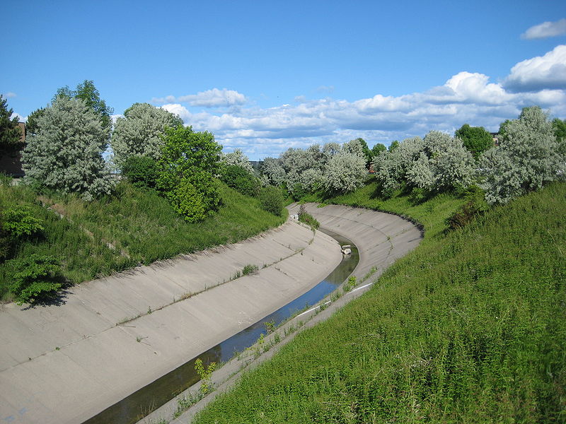
Highland Creek central branch channel at Middlefield Road.
As urbanization spread into the upper portions of the Highland
Creek watershed in the late 1960s and 1970s, the headwaters of the
creek were channelized to facilitate development and to carry away
stormwater as efficiently as possible. As development proceeded,
the flow of water in the creek became more uneven, ranging from
high flows during wet weather events to low flows during the dry
summer months. The unnatural higher flows of water were quickly
funnelled through the system via concrete channels. This has
resulted in severe erosion downstream, especially along the sandy
banks of the lower Highland on the Lake Iroquois plain.
Erosion
There are three main types of stream erosion that are vital as
geological causes and these consist of, abrasion, solution and
quarrying.
- Abrasion is what a stream does to the sides of bedrock and
boulders that are inside of it. The speed that abrasion occurs at
in any stream is determined by its load, which consists of the
complete amount of material that is carried by the stream at any
given time.
- Solution is a chemical compound that has dissolved in the
stream and reacts chemically on the rocks or minerals that are in
the subsurface. One example of this is carbonic acid and this can
be caused due to the water, air and vegetation that decay. Rocks
that have been faced with these solutions dissolved in stream water
include dolomite and limestone.
- Another essential erosional quality of a stream is known as
quarrying. This signifies that the power of the water actually
plucks weak cemented areas from the bedrock or banks and starts to
carry it down stream. Sometimes this action leaves an evident
undercut in the bank or leaves a crack in the bedrock.
Erosion has and continues to occur throughout the Highland Creek
watercourse particularly where the large volume of water has
resulted in an unnaturally wide channel causing the watercourse to
flow as a thin sheet over a broad area. Thus, Highland Creek is
currently characterized by highly variable streamflows, bank
erosion, some risk of flooding, and extensive areas of artificial
stream channel.
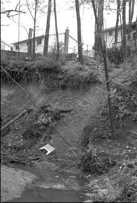
Erosion along Highland Creek
The largest erosion sites in the Highland Creek watershed are
found along the sandy banks of Colonel Danforth Park. Evidence of
past slumping and slope failures can be found there. Several
sections along the bank have been eroded as a result of
undercutting. These erosion scars extend up the valley wall,
measuring from 30 to 70 metres in height.
Logging Requirements:
To log this Earthcache you must complete the following tasks. Email
me your answers for questions 1 to 3 - DO NOT include them
in your "Found It" log.
- Go to
Reference Point #1. Describe what you see on the west side of
Highland Creek. Why is this happening? If erosion is taking place
at this location, what type is it - abrasion, solution or
quarrying?
- Go to
Reference Point #2. What do you see in the creek bed? How did
they get here? How did they get their shape?
- Go to
Reference Point #3. What is happening on the east side of
Highland Creek? Why is it happening on the east side and not on the
west side at this particular location?
Optional: Post an image of any area of Highland Creek that
you find interesting. If you like, include yourself (but not your
GPS) and any members of your group in your photo.