
|
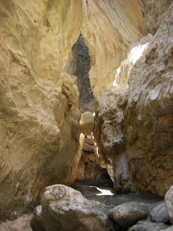
High in the mountains above Fethiye rushing torrents have cut a narrow
gorge or canyon through the mountains, creating Saklıkent Gorge, which
in Turkish means “Hidden City”. A cool refuge on hot summer days,
Saklıkent Gorge is a favourite picnic spot with rustic restaurants
serving delectable fresh trout.
Saklikent Gorge has walls reaching a height of 300 metres and is
navigable for the first 18 kilometres. The walls are so high that
they cut out most of the sunlight and the fresh spring waters that
flow through are freezing cold!
It is 50 km away from the province centre and within the territories
of Kayadibi Village. It is an unique tourism centre, so wing
mountaineering, trekking, swimming possibilities for people fond of
nature with steep rocky mountains, plane trees and clearly flowing
ebullient springs.
Fethiye’nin yukarılarındaki yüksek daglarda delice akan sular daglari oyup, Saklikent adi verilen dar bir bogaz veya baska bir deyisle dar bir kanyon olusturdular. Burasi sicak yaz gunlerinde siginilacak bir yer ve kir restoranlarinda nefis taze sazan baliklarinin bulunabilecegi sevilen bir piknik mekandir.
Saklikent 300 metreye yukselen duvarlarin arasinda ilk 18 kilometresi gelis gidise uygun bir kanyon’dur. Buz gibi kaynak sularinin aktigi yamaclar o kadar yuksektir ki, bir cok bolumde gunes isigi gorulmez.
Saklıkent ilce merkezine 50 km kadar uzaklikta, Kayadibi köyünün sinirlari icinde bulunmaktadir. Burasi dik kayalik daglarin, berrak kaynak sularinin, ulu cinarlarin asigi doga severlerin ucus dagciligi, trekking, yüzme gibi aktiviteler yapilabilmelerine uygun bir turizm merkezidir.
|
Karst is a special type of landscape that is formed by the dissolution of soluble carbonate rocks, including limestone, marble and dolomite.
Karst regions, like this one, contain aquifers that are capable of providing large supplies of water (in this case the melted snow from the Mount Taurus), and its flow can lead to outbreak of a series of physical characteristics such as caves, sinkholes, dry valleys, blind valleys, karst cones, underground rivers, canyons, rocky cliffs and limestone pavement.
The water circulating in places with orthogonal clefts will strongly digging deeper instead of extend its width... That excavation, that will occur until the system finds its "equilibrium profile", forms canyons like this.
|
Karst, kireçtaşi, mermer ve dolomit gibi karbonat esaslı kayaların erimesi ile oluşan arazilere verilen isimdir. Saklıkent gibi karstik bölgelerde büyük miktarda su saglayan akifer’ler bulunur (Saklikent yöresinde bu su Toros daglarinin eriyen karlarindan kaynaklanir). Bu suyun akişi magara, obruk, kuru vadiler, karstik koniler, kör vadiler, yeralti nehirleri, kanyonlar, kayalik yamaçlar kireçtaşi zeminler gibi oluşumlar yaratir.
Birbirine dik yariklarda dolaşan su, enine genişlemek yerine derine doğru inecek şekilde zemini oyar. Kendi denge profiline ulaşana kadar devam eden bu “kazı” işi Saklikent gibi kanyonlari oluşturur.
|
|
To log this Earthcache:
Email me the answer to the following questions, with base of the description above and once authorized write your log and
include the photos required.
Because of the very high walls the GPS precision would produce gigantic errors, I'll describe the places to visit in order to answer the questions.
1- For the first task, you'll have to explore a bit the canyon to the East.
After you walk some meters, you'll realise that the excavation of the water formed curves in the canyon. What's the approximate angle of such curves?
2- When you enter the gorge, there's a walkway.
In the end of the walkway, there's a green vegetation area with lots of water running.
Where's the water coming from?
What kind of karst phenomenon is occurring there?
3- In the same green area after the walkway, how many canalized fountains can you find?
Be aware:
Don't log without my authorization.
Don't forget to put a photo in the log.
The logs who don't fulfil those requirements will be deleted.
Bu Earthcache’e kayit islemek icin
Yukaridaki anlatilanlardan yararlanarak, asagidaki sorulara cevaplarinizi bana email ile gonderin. Benim size olur vermemden sonra kaydinizi yazin ve gereken fotograflari ekleyin.
Yüksek yamaclar nedeni ile GPS olçümleri cok büyük ölçüde hatali sonuclar verecektir. O nedenle, sorulari cevaplamak icin ziyaret edilecek yerleri tarif ederek belirtecegim.
1. Ilk olarak, kanyonu doguya dogru biraz arastirmaniz gerekecek.
Biraz yürüdükten sonra suyun kanyonda büklümler oluşturmuş oldugunu göreceksiniz. Bu büklümlerin (kavislerin) yaklaşık olarak açisi nedir?
2. Kanyon girisinde bir yürume yolu vardir.
Yurume yolunun sonunda, cok miktarda suyun aktigi
bir yeşil bitki alani vardir.Bu su nereden gelmektedir?
Burada hangi erozyon süreclerinin sürmekte oldugunu dusunuyorsunuz?
3. Yurume yolunun sonundaki yeşillik alanda kaç tane kanallasmis cesme bulunmaktadir?
Dikkat
Benim onayim olmadan kayit girisi yapmayiniz.
Kayida bir fotograf eklemeyi unutmayiniz.
Bu sartlara uygun olmayan kayitlari silmek zorunda kalacagiz.