Ribeira Da Janela, la belle EarthCache
Ribeira Da Janela, la belle
-
Difficulty:
-

-
Terrain:
-

Size:  (other)
Please note Use of geocaching.com services is subject to the terms and conditions
in our disclaimer.
Ribeira Da Janela, la belle...
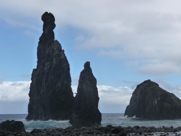
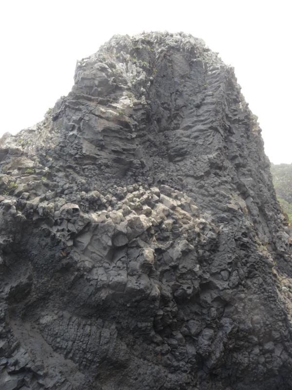
A typical landscape. Just amazing!
Ribeira da Janela
Sorry Google translation O início da criação das ilhas da Madeira remontam 20 milhões ano com uma erupção vulcânica submarina primeiro no fundo do Atlântico. Depois, outras erupções ocorreram até que o jogo ultrapassou a área vulcânica e tornou-se uma pequena ilha que tem crescido progressivamente no tempo. Ilha da Madeira é o cume de uma montanha crescente de 5000m, apenas 2 / 5 da ilha está fora da água. O vulcanismo da ilha foi inicialmente conhecido fases explosivas (expulsão violenta de vários materiais) e, em seguida, as fases que produziu lava efusiva. (Isto é típico do Etna, na Sicília, também).
1. Que tipo de Phenomen geológicas você pode observar aqui na?
2.In rocha antes de chegar na praia, 5m, há alguma alta um olho em você. Quem é?
Primeiro, você deve enviar suas respostas. Vamos enviar a autorização para efetuar login
Géologie de Madère, les origines de Madère.
Les débuts de la création de l'archipel de Madère remonteraient à 20 millions d'années avec une première éruption volcanique sous-marine au fond de l'Atlantique. Ensuite, d'autres éruptions ont eu lieu jusqu'au moment où la partie volcanique a dépassé la superficie et est devenue une petite île qui s'est agrandie au fur et à mesure du temps. L'île de Madère est donc le sommet d'une montagne qui s'élève à 5000m,seuls les deux cinquièmes de l'île sont au hors de l'eau.
Le Volcanisme de l'île a d'abord connu des phases explosives (expulsion violentes de divers matériaux) et ensuite, des phases effusives qui ont produit de la lave.(Ceci est caractéristique de l' Etna, en Sicile, aussi).
Aujourd'hui, on peut distinguer 3 grands ensembles de reliefs :
- Le massif volcanique central, où se trouvent les sommets les plus élevés de l'île (Pico Ruivo, Pico Areeiro).
- L'ensemble occidental séparé du massif volcanique par les vallées de Ribeira Brava et de São Vincent et dominé par le plateau de Paul da Serra.
- La zone orientale qui se termine avec la pointe de São Lourenço.
La dernière phase de volcanisme a eu lieu à la périphérie de l'île. On peut apercevoir aujourd'hui, des cônes volcaniques de cette époque : les collines à l'Ouest de Funchal, les pics de São Marthino, de Cruz et de Barcelos et le Pic da Torra à Camara dos Lobos. A Caniço et à São Lourenço on peut voir des cônes volcaniques dont la partie extérieure a été détruite par l'érosion marine.
Les hautes falaises que l'on peut voir actuellement à Madère, sont le résultat de l'érosion marine, les bords se sont écroulés créant parfois des terrains aplatis à leurs pieds.

The beginning of the creation of the archipelago of Madeira would go back up to 20 million years with a first submarine volcanic eruption at the bottom of the Atlantic Ocean. Then, the other eruptions took place until the moment when the volcanic part exceeded the surface and became a small island which got bigger according to time. The island of Madeira is thus the mountain top which rises in 5000m (only both fifth of the island are in outside the water). The Volcanism of the island knew at first explosive phases (eviction violent of diverse materials) and then, effusives phases which produced of the lava. (This is characteristic of Etna, in Sicily, also).
Today, we can distinguish 3 complexes of reliefs: - The central volcanic massif, where are the highest summits of the island (Pico Ruivo, Pico Areeiro).
- The western set separated from the volcanic massif by the valleys of Ribeira.
-The western set separated from the volcanic massif by the valleys of Ribeira Brava and from São Vincent and dominated by Paul da Sera tray.
- The oriental zone which ends with the headland of São Lourenço. The last phase of volcanism took place in the suburb of the island.
We can perceive today, volcanic cones of this period: hills on the West of Funchal, peaks of São Marthino, Cruz and Barcelos and the Peak da Torra to Camara dos Lobos. To Caniço and to São Lourenço we can see volcanic cones the outside part of which was destroyed by the marine erosion.
Questions:
1. What kind of geological phenomen you can observe here in the ocean?
2.In the rock before arriving on the beach, 5m, high there is some one watching you. Who is it?
Write us an e-mail with your answers and WAIT for the log permission. Don't forget to put a picture of you or your GPS on your log, if you want to do so, of course!
Questions:
1.Dans l'océan, vous observerez quelque chose de très typique. Qu'est-ce?
2.En hauteur (5m), avant la plage, quelqu'un veille sur vous. Qui est-ce?
Envoyez-nous vos réponses et attendez l'autorisation de logger. Pensez à mettre votre photo ou celle de votre Gps sur votre log, si vous le désirez bien sûr! Merci et bon voyage!
More informations?
http://fr.wikipedia.org/wiki/%C3%8Ele_de_Mad%C3%A8rehttp://www.madeira-web.com/madeira.html
http://premiumorange.com/jpelmont/madeira.html
http://en.wikipedia.org/wiki/Madeira
 magnema

| I am a proud |
 |
Additional Hints
(No hints available.)