
Rheinquelle – Lai da Tuma
Einer der längsten Ströme und der
bedeutendsten Schifffahrtsstraßen Europas hat hier seinen Ursprung.
Der Rhein entspringt im Tomasee dem
Lai da Tuma
auf 2345m üNN in der Nähe des
Oberalppasses. Streng genommen entspringt hier der Vorderrhein, der
sich erst in der Nähe von Tamins mit
dem Hinterrhein zum Alpenrhein
vereinigt.
Es gibt in dieser Region noch viele andere
Zuflüsse, die auch die Quelle des Rheins sein könnten. Zur
Bestimmung der Quelle eines Flusses werden folgende Merkmale
herangezogen:
- Die Fliesslänge von
einer Quelle bis zur Mündung.
- Die Abflussmenge,
also der wasserreichste Verlauf einer bestimmten Quelle-Mündung-Strecke
- Die Größe der
Einzugsgebiete bestimmter Quellflüsse bzw. bestimmter
Quellflussabschnitte.
- Eventuell die Höhe
üNN der Quelle.
So könnte der Medelserrhein etwa, der von der Quelle bis zum
Zusammenfluss bei Tamins 5 km mehr
zurücklegt als der Vorderrhein, der eigentliche Quellfluss des
Rheins sein. Die Durchflussmenge des Vorderrheins ist allerdings am
Zusammenfluss größer.
Die Durchflussmengen von Vorder- und
Hinterrhein können beim Zusammenfluss nur geschätzt werden, da
direkt vor dem Zusammenfluss keine Messstationen existieren. Auf
der Grundlage von Schätzungen an den letzten Messstationen wurde
allerdings der Vorderrhein als der durchflussstärkere Quellfluss
angenommen.
Während der letzten Eiszeitbedeckte der
mächtige Vorderrheingletscher das ganze Tal. Noch heute sind die
Gletscherschliffgrenzen auf 2500 m üNN
bis 2700 m üNN im Bündner Oberland gut
zu sehen. Diese typische, von Gletschern geformte Gebirgslandschaft
des Oberalppasses ist das Quellgebiet des Vorderrheins. Der
Eisstrom ist längst geschmolzen, zurückgeblieben ist die Firnmulde,
in der sich heute das Quellwasser des Vorderrheins sammelt –
der Lai da Tuma. Er liegt im Schatten der Bergkette
Six Madun,
am Fusse des Piz Badus, der zum Gotthardmassiv gehört.
Am Tomasee findet
man einige der abgebildeten Tafeln
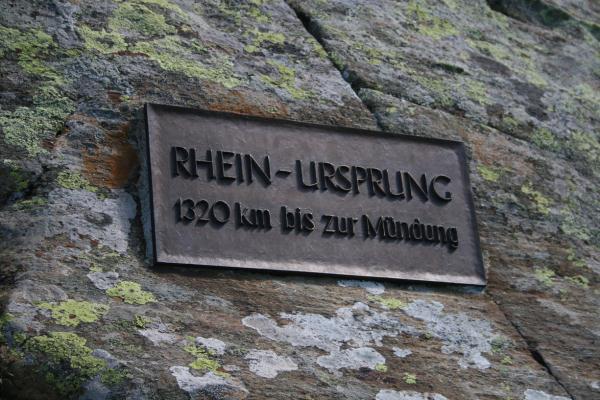
Nach neusten Erkenntnissen enthalten diese
Tafeln allerdings einen Fehler. Bis 1960 wurde die Länge des Rheins
mit 1230 km angegeben. „Die Zahlenangaben der modernen
Nachschlagewerke sind schlicht falsch.“ sagt Bruno Kremer von
der Universität Köln. Der Fehler habe sich immer weiter verbreitet,
weil offenbar einer vom anderen abgeschrieben hat. (vgl. www.spiegel.de/wissenschaft/natur/0,1518,686012,00.html)
Der schiffbare Rhein ist und bleibt allerdings
883 km lang, daran hat der offensichtliche Zahlendreher nichts
geändert.
Man erreicht den See in einer etwa 1 ½
stündigen Wanderung vom Oberalppass
aus.
Logbedingungen:
- Messe die
Temperatur des Wassers im Tomasee.
Solltest du kein geeignetes Thermometer dabei haben, kannst du
eines bei N46°37.991 E008°40.275 ausleihen (siehe auch Spoiler).
Bitte aber auch wieder zurücklegen, damit auch andere die
Möglichkeit einer Messung haben.
- Nenne neben dem
Medelserrhein zwei weitere quellnahe
Zuflüsse in den Rhein.
- Mache ein Foto von
einer der Tafeln am See z.B. bei N46°37.992 E008°40.469 und deinem
GPS und hänge das Foto dem Log an.
Sende die Antworten
zu 1 und 2 an den Owner und warte auf
die Logfreigabe!

Source of the Rhine
– Lai da Tuma
One of the largest
rivers and one of the most important waterways in Europe has its
seeds right here. The Rhine has its source at the Lai da Tuma at an altitude
of 2345 m a.s.l. near the Oberalppass. Strictly speaking the
“Anterior-Rhine” has its source in this area. Near
Tamins the “Anterior-Rhine”
flows together with the “Posterior-Rhine” to be the
river Rhine then.
In this region
there are many feeders which may be the source of the Rhine. To
determine a source of a river there will be consulted the following
attributes.
- The length between
the source and the estuary.
- The quantity of
the flow, the most water-rich section between the source and the
estuary.
- The dimension of
the catchment area of certain frontal flows or sections of frontal
flows.
- Optionally the
altitude a.s.l. of the
source.
Therefore the
Medelser Rhine could be the source of
the river Rhine, because his length from the source till the
confluence with the Posterior-Rhine is 5 km longer than the length
of the Anterior-Rhine. Though the quantity of
the flow of the Anterior-Rhine is bigger.
The
Posterior-Rhine could also be the source of the river Rhine even
though the distance from the source to the confluence with the
Anterior-Rhine is short. The quantity of the flow of the two
frontal flows before the point of confluence can only be estimated.
There are no measurement stations nearby. On basis of the values
from the two nearest measurement stations it is estimated that the
Anterior-Rhine has the bigger quantity of flow.
During the last
glacial period the mighty Anterior-Rhine-Glacier covered the whole
valley. Till now the marks of the glacial scratch can be seen
between 2500 and 2700 m a.s.l. in
Bündner Oberland. This typical glacial formed landscape
near the Oberalppass is the source
region of the Anterior-Rhine. The glacier melted long time ago but
the firn-basin is left-over. In this
firn-basin the spring-water of the
Anterior-Rhine is conglomerated – the Lai da Tuma. This lake is
situated in the shade of the mountain range of Six Madun, submontan Piz
Badus which belongs to the
Saint-Gotthard Massif.
At the Lai
da Tuma you
may find two information boards with the following
inscription
According to the
latest conclusions is this information wrong. Till 1960 the length
of the Rhine was declared with 1230 km. “The declarations of
the modern reference books are wrong.”, says Bruno Kremer
from the Cologne University. The fault has been divulged, because
everyone write off someone else.
The navigable
Rhine stays 883 km long, at it the
apparently transposed digits didn’t change
anything.
You can reach the
Lai da Tuma
the source of the Rhine with a hike of 1 ½ hours from the
Oberalppass.
Logterms
- Measure the
water-temperature of Lai da
Tuma. If you don’t have an
adequate thermometer with you, you can borrow one at N46°37.991,
E008°40.275 (see also Spoiler). Please bring it back after your
measurement so that following people can also fulfill the logterms.
- Call me two other
feeders near the source besides the Medelser Rhine
- Take a photo of
one of the Informations boards pictured
above (f.e. at N46°37.992, E008°40.469)
and your GPS and attach this photo to your log.
Mail the answers
to exercise 1 and 2 to the owner to get approval to log.