Ocres de Roussillon EarthCache
-
Difficulty:
-

-
Terrain:
-
Size:  (other)
Please note Use of geocaching.com services is subject to the terms and conditions
in our disclaimer.
 Dans le Parc Naturel régional du Luberon, on trouve le village Roussillon, reconnu pour les ocres.
 In the Parc Naturel régional du Luberon, the village Roussillon is well known for its ocres.
 In het Parc Naturel régional du Luberon, is het dorp Roussillon bekend om zijn okerrijke bodem.
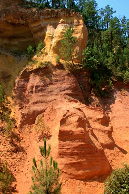
Les carrières d'ocre de Roussillon
Par les recherches géologiques du professeur Jean-Marie Triat: Il y a 110 millions d'années, la terre était recouverte par la mer. Les mouvements de sable vert a porté sur la faible profondeur des fonds marins. Le sable transporté un cocktail de minéraux, le quartz, le calcaire et surtout glauconie, une association de minéraux argileux riches en fer. Il y a 100 millions d'années, la mer se retire. Un nouveau continent émergé et le sable vert a été exposée à l'air. Le climat chaud et humide de la période en vedette très fortes pluies. Cette lessivé les sols sableux et le glauconite dissous. Les grains de sable résisté et les autres minéraux cristallisés que l'argile siliceuse, la kaolinite et les oxydes de fer (geothite jaune et hématite rouge). L'hématite rouge concentré à la surface, formant une croûte ferrugineuse qui protégeait les falaises contre l'érosion. |
 |
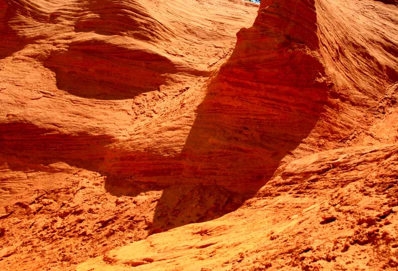 |
L'ocre est une combinaison de kaolin et de fer, légèrement mélangé avec du quartz et de kaolin, qui est dominant. Le sol ocre de Roussillon est structuré de couches de kaolinite. Quand elle est pure, elle reste blanche, tandis que les quantités aléatoire naturel d'oxyde de fer peut lui donner une gamme de couleurs allant du jaune pâle au rouge violacé. La riche variété de couleurs peuvent être admirés dans la carrière d'ocre à Roussillon, aussi connu comme le "Colorado provençal". |
Les carrières d'ocre de Roussillon ont été exploitées depuis la fin du 18e siècle. Jusqu'en 1930, des milliers de personnes ont travaillé ici. Aujourd'hui, il n'est pas permis à l'ocre creuser, pour empêcher l'ensemble du site d'être fouillé et disparaissent. L'un des anciens sites a été ouvert au public pour un montant de 3,00 € par personne. Suite à la 'Sentier des Ocres', deux courtes promenades de 35 et 50 minutes à travers la carrière, les visiteurs voient le sol richement colorés d'ocre de près dans toute sa splendeur.
(Sources: panneaux d'information 'Sentier des ocres', wikipedia) |
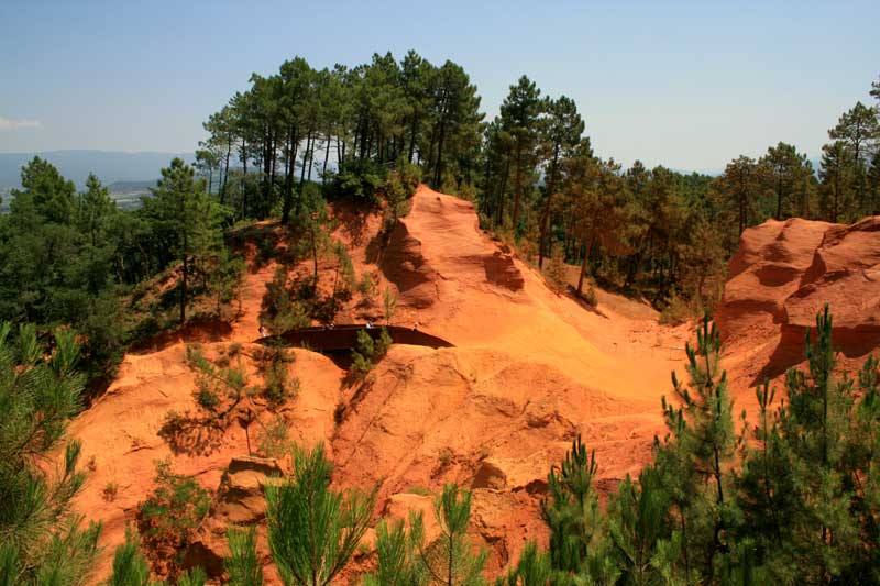 |
Afin de se connecter à ce cache, il n'est pas absolument nécessaire d'entrer dans la carrière. Cependant, nous recommandons à chacun de le visiter. Il est vraiment à visiter.
Questions: Aller aux coordonnées mentionnées ci-dessus. Il ya un grand cadran solaire entouré par des informations sur la carrière d'ocre. Pour obtenir l'autorisation d'enregistrer ce Earthcache, vous devez répondre aux questions suivantes et de nous envoyer les réponses. Vous pouvez fixer l'image à votre journal (log).
1: La terre ocre dans le Vaucluse est composé de sable (80%) et ocre (20%). De quoi est composé cette ocre?
2: Qui a découvert le procédé d'extraction de l'ocre du sable ocreux et en 1785 est devenu le premier fabricant d'ocre?
3: Quelle végétation a colonisé les carrières après l'exploitation?
4: Nous voulons voir une photo de vous avec votre GPS et de la cadran solaire ou (c'est la plus belle) à la carrière d'ocre.
The ochre quarry of Roussillon
According to the geological research of Professor Jean-Marie Triat: 110 million years ago, the earth was covered by sea. Movements of green sea sand covered the shallow depths of the sea bed. The sand carried a cocktail of minerals, quartz, limestone and especially glauconite, an association of clay minerals rich in iron. The sea withdrew 100 million years ago. A new continent emerged and the green sand was exposed to the air. The hot, wet climate of the period featured very heavy rains. This leached the sandy soil and the glauconite dissolved. The grains of sand resisted and the other minerals crystallised as siliceous clay, kaolinite and iron oxides (yellow geothite and red hematite). The red hematite concentrated at the surface, forming a ferruginous crust that protected the cliffs against erosion. |
|
|
Ochre is a combination of kaolin and iron, lightly mixed with quartz and in which kaolin is dominant. The colourful ochre soil of Roussillon is structured of layers of kaolinite. When pure, it remains white, whereas the natural random quantities of iron oxide can give it a range of colours from pale yellow to violet red. The rich variety of colours can be admired in the former ochre quarry at Roussillon in France, also known as the "Colorado Provençal". |
The ochre quarries of Roussillon have been exploited since the late 18th century. Until 1930, thousands of people worked here. Today it is not allowed to dig ochre, to prevent the whole site of being excavated and disappear. One of the former sites has been opened to the public for a fee of € 3.00 per person. Following the 'Sentier des Ocres', two short walks of 35 and 50 minutes through the quarry, visitors will be able to see the richly coloured ochre ground up close in its entire splendour.
(Sources: billboard sentier des ocres, wikipedia) |
|
In order to log this cache it is not absolutely necessary to enter the quarry. However, we recommend everyone to visit it. It is really worth visiting.
Assignment: Go to the coordinates listed above. There is a large sundial surrounded by billboards on the ochre quarry. For permission to log the Earthcache, you must answer the following questions and mail us the answers. You can attach the picture to your log.
1: The ochre ground in the Vaucluse is composed of 80% sand and 20% ochre. Of what is this ochre composed?
2: Who discovered the extraction process of ochre from ochre sand and became the first manufacturer of ochre in 1785?
3: What new vegetation lives at the quarries after their closure?
4: We would like to see a picture of yourself with your GPS and the sundial or (even better) in the ochre quarry.
De Okergroeve van Roussillon
Volgens geologisch onderzoek van Professor Jean-Marie Triat: Ongeveer 110 miljoen jaar geleden lag de aarde nog bedolven onder de zee. In de ondiepere delen werd de zeebodem door bewegingen van het water bedekt met een laag groen zeezand. Dit zand bevatte een diversiteit aan mineralen, zoals kwarts, kalksteen en met name glauconiet, een verbinding van ijzerrijke kleimineralen. Toen 100 miljoen jaar geleden de zee zich terug trok, werd het groene zeezand blootgesteld aan de lucht. Door het hete vochtig klimaat, gekarakteriseerd door zware regenbuien, spoelde de zandbodem uit. Hierbij loste de glauconiet op. De zwaardere zandkorrels bleven achter en overige mineralen kristalliseerden in kiezelvormige klei, kaoliniet en ijzeroxiden (gele geothite en rode hematite). De rode hematite concentreerde zich aan het oppervlak, waarbij zich een ijzerhoudende korst vormde die de kliffen beschermde tegen erosie. |
|
|
Oker is een combinatie van kaolien en ijzer, lichtelijk vermengd met kwarts, waarin de kaolien dominant aanwezig is. De gekleurde okergrond van Roussillon is opgebouwd uit laagjes kaoliniet. In zijn zuivere vorm is deze wit van kleur. De aanwezigheid van ijzeroxide in de bodem doet het kaoliniet verkleuren. Afhankelijk van de hoeveelheid ijzeroxide kan deze varieren in een diversiteit aan kleurschakeringen van lichtgeel tot rood-violet. De rijke verscheidenheid aan kleuren zijn allemaal te bewonderen in de voormalige okergroeve van Roussillon, in Frankrijk ook wel bekend onder de naam "Colorado Provençale". |
De okergroeves van Roussillon werden geëxploiteerd sinds het einde van de 18e eeuw. Tot aan 1930 vonden hier duizenden mensen werk. Vandaag de dag is het verboden om er oker te delven. Dit verbod is ingesteld om te voorkomen dat de gehele plek zou worden afgegraven en dus zou verdwijnen. Een van de voormalige groeves is opengesteld voor publiek, voor een tarief van € 3,00 per persoon. Via de 'Sentier des Ocres', twee korte wandelingen van 35 en 50 minuten door de groeve, kunnen bezoekers de rijk gekleurde okergrond in al zijn pracht van dichtbij ervaren.
(bronnen: infobord sentier des ocres, wikipedia) |
|
Voor het loggen van deze cache is het niet persé noodzakelijk om de groeve te betreden. We kunnen het iedereen wel aanraden. Het is een bezoek zeker waard.
Opdracht: Ga naar bovenstaand coordinaat. Daar bevindt zich een grote zonnewijzer omringd door informatieborden over de okergroeve. Om de earthcache te mogen loggen, moet je een paar opdrachten uitvoeren. Beantwoord de volgende vragen en mail ons de antwoorden. De foto kun je bij je log plaatsen.
1: De okergrond in de Vaucluse is samengesteld uit 80% zand en 20% oker. Waaruit is dit oker samengesteld?
2: Wie ontdekte het proces om oker te delven en werd in 1785 de eerste okerfabrikant?
3: Welke nieuwe vegetatie is ontstaan in de mijnen nadat deze gesloten werden?
4: We zien graag een foto van jezelf met je GPS bij de zonnewijzer of (nog mooier) in de okergroeve.
Additional Hints
(No hints available.)