|
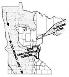
Minnesota was largely covered by glaciers many times during the last million years. The ice flowed across the state from both the northeast and the northwest. As it advanced along separate paths, it scraped up, crushed, and carried with it thousands of cubic kilometers of rock debris, called glacial drift. This was deposited in a thick layer over much of the state. About 25,000 years ago, a tongue-shaped lobe of ice called the Superior lobe advanced across Minnesota from the northeast. This ice eroded the mostly igneous bedrock in Ontario and the Lake Superior region and deposited a reddish, sandy, and rocky drift. Soils that developed from this drift are not the most fertile. More recently another lobe of ice advanced across Minnesota from the northwest. This was named the Des Moines lobe because its point of farthest advance was Des Moines, Iowa. Drift deposited by this ice contains crushed pieces of sedimentary marine shales and limestones eroded from the Winnipeg Lowland in souther Manitoba. Soils developed from this drift are typically gray to brown, full of clay, and rich in lime, magnesia, and potash. These soils are quite fertile and good for agriculture. In the Elk River region, deposits from both the northeast and the northwest occur in close proximity. Most of the quite fertile material at the surface was deposited by an eastern offshoot of the Des Moines lobe called the Grantsburg sublobe. The older Superior lobe deposits are closer to the surface, however, and may be mixed with those above. Thus, the fertility of the soils in the Elk River region will vary depending on the proportionate mix of the two parent drifts. River terrace deposits of sand and gravel are also common near Elk River. The Mississippi River established its present course during the final decline of the glaciers. Water from the melting ice followed a number of different routes until finally cutting the valley in which the river now flows. Sand terraces mark former river courses.
1. What is your Elevation at the site?
2. How many drifts were present in this area?
3. How many years ago was the Des Moines lobe present?
4. Estimate the distance to the far shoreline in feet.
5. Upload Photo of you at the site.(optional)
Send me an email with the info to claim credit. |