<
/>
The coordinates will lead you to the banks of the Mississippi
River with a fine example of exposed St. Peter Sandstone. The bluff
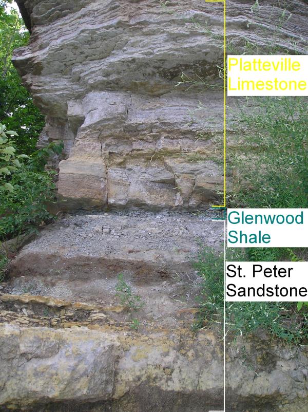
face along the river is comprised of three main layers. Underneath
the top soil and glacial drift, the three layers from top to bottom
are the Platteville Limestone, Glenwood Shale, and St. Peter
sandstone (1). You can tell the St. Peters layer by its appearance.
It is gradually eroded, unlike the vertical, sheering Platteville
Limestone that caps the bluffs. The Glenwood Shale is a thin, dark
layer between the St. Peters and Platteville that easily erodes
(2). The St. Peter Sandstone formation covers 225,000 square miles
of the upper Mississippi Valley, with an average thickness of
100’. The thickness of the St. Peter in the Twin Cities area
ranges between 80 and 160’ (3). It is prized for its pure
white sand, and is important as a conduit for groundwater (2).

<
/>
Its white color is a clue to how it was formed. The sand grains
that make up the sandstone are fine-medium size quartz sand, and
are well-sorted and well-rounded (3). In order for it to acquire
its pure white color, impurities had to have been sorted and
removed from the sand. This suggests that the rock has an aeolian
deposition, or that wind was the primary erosion force in its
creation. Wind is the only erosive force capable of sorting finely
rounded sand from subangular sand (3). Furthermore, the
grains’ textual maturity (round shape), was caused by the
grains colliding with each other in the air (2). Water erosion does
not create enough force between the grains necessary to create that
level of textual maturity (2). Since wind was the primary erosive
force, it would seem that the environment was rather windy during
the St. Peter’s formation, like a desert. However, the
geometry and thickness of the formation, and the presence of trace
fossils suggest that the sandstone may have formed in a coastal or
shallow marine environment, such as the inland sea that once
covered the land (3). The transition from St. Peter Sandstone to
Glenwood Shale shows that the St. Peter Sea became deeper (3).
To claim credit for this EarthCache, email us the answers to the
following:
1. Estimate the height of the exposed sandstone to determine the
approximate St. Peter Sandstone accumulation at this location. Take
an elevation measurement at the river level, and subtract that from
another elevation reading where the sandstone transitions to
shale.
2. Examine the sandstone grains. What shape are the grains? Are
they uniform in size and shape? Or do they have different sizes and
shapes? What would explain the grain texture you see?
3. Look around you. What evidence do you see that would support
the theory that the St. Peter Sandstone was formed in a coastal,
shallow marine environment?
4. Although not required, photos of your visited are encouraged.
There are some fantastic views at this location!
Sources used:
1. Ojakangas, R. W., & Matsch, C. L. (1982).
Minnesota’s geology. Minneapolis: University of Minnesota
Press.
2. GEO 1001/1101: Earth and Its Environments (2010). River
bluffs outcrop. Accessed June 30, 2010 from
http://www.geo.umn.edu/courses/1001/campus/pages/river/river.htm.
3. Mazzullo, J. M., & Ehrlich, R. (1987). The St. Peter
Sandstone of Southeastern Minnesota: Mode of deposition. In Sloan,
R. E. (Eds.), Report of investigations (Minnesota Geological
Survey). St. Paul, MN: University of Minnesota. 35, 44-51.