Red Sand Beach EarthCache
-
Difficulty:
-

-
Terrain:
-

Size:  (other)
Please note Use of geocaching.com services is subject to the terms and conditions
in our disclaimer.

Tucked away in the village of Hana at the eastern tip of Hawaii's Maui Island, is a very special beach.
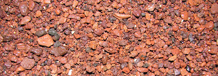
Kaihalulu Beach, better known as Red Sand Beach, takes it's popular name from the red cinders that cover the small beach.

The entire state of Hawaii is a geologist's dream, with hundreds of beaches, but this tiny bay is the only place in the chain of islands where you will see a red beach.
At this point, you may be asking yourself why the beach is red? Well, here's where earth science becomes fun.
The red pocket beach is tucked into Ka'uiki Hill, which is a cinder cone hill. Erosion of the crumbling hill has created the beach.
Cinder cones are steep conical formations above volcanic vents and are common volcanic landforms found throughout the world.
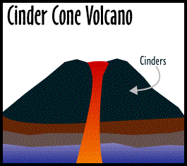
Cinder cones form rapidly from ejected loose, grainy cinder fragments of a cinder cone volcano. The fragments are discharged from a vent and fall back to earth around the vent in a conical shape. This type of volcano is smaller than others, usually no more than a mile wide and a thousand feet tall with a small crater at the top.
The rich iron content of the cinders give the beach its signature red color.
To access the beach from land, take the short trail down the hill. The easiest path is from the Hana Community Center located at the end of Ua'Kea Rd.
Park in the public parking spaces or along the road. The path begins on the south side of the community center and passes an old Japanese cemetery. The path then parallels the shoreline, and back up around the cinder cone to the red sandy beach area.
Click here for an aerial view of the parking area, the trail and the beach.
Be careful on the path. It can be very slippery due to the cinders and pine needles, especially when wet.

To log this earthcache, please visit the site and submit your answers to the following questions:
1) In your estimation, how wide is the caldera of the cinder cone (the width of the beach area)?
2) How would you describe the size of the ground cinder sand of the beach?
3) How would you describe the current state of the cinder cone?
OPTIONAL: Photos of yourself or surroundings will be met with giddy earthcache-geek excitement.

Resources and credits:
Genny Anderson, marinebio.net
mauiguidebook.com
Oracle Educations Foundation
Robert I. Tilling, Volcanoes
scenicplaces.com
Wheeling Jesuit University
Wikipedia
World's Best Beaches

Placed by a member of the Denton Area Wayward Geocache Seekers.
Placed with permission of Maui County Parks and Recreation.
Additional Hints
(Decrypt)
Pnpuref unir abgrq gung fbzrgvzrf ahqr fhaonguref ner ba gur ornpu . Lbh'ir orra jnearq vs ahqvgl bssraqf lbhe frafrf be lbh cersre gb furygre lbhe puvyqera sebz vg.