Zillertal Alps Nature Park EarthCache
Zillertal Alps Nature Park
-
Difficulty:
-

-
Terrain:
-

Size:  (other)
Please note Use of geocaching.com services is subject to the terms and conditions
in our disclaimer.
Naturpark Zillertaler Alpen
Zillertal Alps Nature Park

 Österreichische Version:
Der weitläufige Hochgebirgs-Naturpark Zillertaler Alpen erstreckt sich vom Bergsteigerdorf-Ginzling bei 1.000 m bis auf 3.509 m am Hochfeiler.
Gemeinsam mit weiteren Schutzgebieten in Nord-,Süd- und Osttirol, bildet der Hochgebirgs-Naturpark Zillertaler Alpen den größten Schutzgebietsverbund Europas!
Von Mayrhofen verzweigt sich die Naturparkregion in seine vielen Seitentäler. Eine Hochgebirgslandschaft mit zerklüfteten Gletschern, tosenden Bächen, Wasserfällen, schroffen Felsen und einsamen Gipfeln – viele davon über 3.000 m hoch. Wilde, faszinierende Naturlandschaft, die eng verwoben ist mit dem menschlichen Leben und Wirtschaften, was sich heute in der vielfältigen Kulturlandschaft offenbart.
Die Naturparkregion hat zahlreiche interessante Facetten zu bieten – die Landschaft, die Geschichte, die Tradition. Besonders auszeichnend für den Naturpark, der seit 1991 unter Naturschutz steht, sind neben den Gletschern und dem bemerkenswerten Artenreichtum die zahlreichen Mineralienvorkommen im Gebiet.
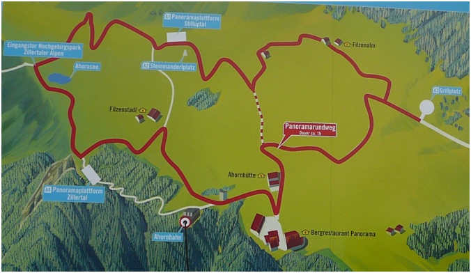
Begebt Euch nun zur Panoramaplattform „Stilluptal“ und beantwortet folgende Fragen, um den Earthcache loggen zu können:
1. Kristallformen: Wieviele sind hier abgebildet? A
2. Metamorphose eines Eiskristalls: Wie heißt dieser im 2. Jahr? B
3. Der größte Gletscher der Zillertaler Alpen ist das Schwarzensteinkees mit einer Fläche von 5,1km². Gletscher werden im Zillertal auch „Kees“ genannt, das vom althochdeutschen Wort Wort „chees“ (=???) abstammt. C
4. Mineralien: Einige Mineralien wurden am Floitenkamm entdeckt. Wie heißt das Mineral in der Mitte? D
5. Es wäre schön, wenn ihr von Euch oder Eurem GPS ein Foto vor der Aussicht oder den dort befindlichen Tafeln macht!
Schickt Eure Antworten an folgende Email-Adresse und hängt Euer Foto an das Log an:
A.B.C.D@gmx.de
Beispiel: 21.Schneeflocke.Erde.Bleiglanz@gmx.de
 English Version:
The nature park extends from 1000m at Ginzling, up to 3509m at Hochfeiler via all the altitudinal belts in the central Alps.
Along with the nature park, the communities of Brandberg, Finkenberg, Ginzling, Mayrhofen and Tux have a protection for their unique natural and cultural landscape around the main ridge of the Zillertal Alps.
Here nature takes priority - harsh development is expressly forbidden. The high mountain nature park extends from the Reichenspitz group in the east, to the Olperer in the West and from Mayrhofen in the north, to the Italian national border. The nature park region splays out from Mayrhofen, like the fingers in your hand, into its many lateral valleys.
This is a high mountain landscape with craggy glaciers, thunderous streams, waterfalls, rugged cliffs and solitary summits – many of which are over 3000m high. A wild, fascinating natural landscape, which is closely interweaved with people and economic systems and which today manifest itself in the diverse cultural landscape.
The profusion of flowers in the meadows and mountain pastures in the broad trough valleys, surrounded by glaciers, alternating with the forest areas make for the charm of this landscape, which is held in high esteem by guests and locals alike.
Go to the panorama platform „Stilluptal“ and answer the following questions, to claim this earthcache:
1. Forms of crystals (Kristallformen): How many forms do you see? A
2. Metamorphosis of a mono-crystal: How do you call it in the second year? B Help :[zweites Jahr (???)]
3. The biggest glaciers of the Zillertal Alps is the „Schwarzensteinkees“ with a surface area about 5,1km². In the Zillertal glaciers are called „Kees“, which stems from the Old High German word „chees“ (=???). C Help: [ das vom althochdeutschen Wort Wort „chees“ (=???) abstammt]
4. Minerals: At the „Floitenkamm“ were found some minerals. How do you call the mineral in the middle? (take the german word) D
5. Es It would be great if you would add a picture of your GPSr and/or yourselft at the view or the tables in the background.
Mail the answers of the above questions to the email address below and upload the photo to your log.
A.B.C.D@gmx.de
example: 21.Schneeflocke.Erde.Bleiglanz@gmx.de
Additional Hints
(Decrypt)
[A]: Qerur na qra Eäqrea
[E]: Ghea gur jurryf