Dinosaur Ridge - Ripple Marks EarthCache
Dinosaur Ridge - Ripple Marks
-
Difficulty:
-

-
Terrain:
-

Size:  (other)
Please note Use of geocaching.com services is subject to the terms and conditions
in our disclaimer.
RIPPLE MARKS are sedimentary structures (i.e. bedforms of the lower flow regime, mostly in sandy bottoms) and indicate agitation by water (currents or waves) or wind.
Ripple marks formed by water consists of two basic types - SYMMETRICAL and ASYMMETRICAL
1) Symmetrical ripple marks (also called wave-formed or bidirectional) are produced by waves or oscillating water. They have almost sinusoidal profile. These ripple marks indicate an environment with weak currents where water motion is dominated by wave oscillations (sand grains are moving in both directions, forward and backward).
2) Asymmetrical ripple marks (also called current or unidirectional) are asymmetrical in profile, with a gentle up-current slope and a steeper down-current slope. Because of this unique geometry, asymmetrical ripples in the rock record may be used to determine ancient current directions or paleocurrent directions. These ripple marks are formed in fluvial and aeolian depositional environments (sand grains are moving only in one direction).
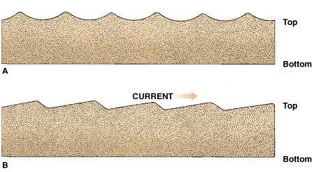 A - symmetrical ripple marks, B - asymmetrical ripple marks
Examples of ripple marks:
Ripple marks, you can see at this location, were formed in intertidal zone along Western Interior Seaway during Late Cretaceous - Cenomanian (93–100 millions years ago)
Questions to answer (email me your answers, do NOT post them in your log):
1. What type of ripple marks can you see on Dinosaur Ridge at this location?
2. Estimate the distance between the crests of these ripple marks
FROM THE ROAD WITHOUT APPROACHING the actual marks!!!! (Precise accuracy is not required)
3. By what organism may the ripple marks have been preserved?
4. In what type of sandstone you can find the ripple marks here?
Mandatory task is to post a picture of you or your GPS or personal item (anything what proves your visit of the location) in front of the ripple marks. Logs without answers and picture will be deleted. For this cache the rule is valid since July 7th, 2019. (DO NOT INCLUDE THE SIGN IN YOU PICTURE).
PREVIOUS VISIT DOES NOT COUNT!!
"FOUND IT" logs will be DELETED WITHOUT FURTHER NOTICE if the answers are not received and the picture is not uploaded within seven days of the post date.
sources: Harold L. Levin, The Earth Through Time, 7th ed., Willey Interscience, 2003.
http://en.wikipedia.org/wiki/Current_ripples
Additional Hints
(No hints available.)