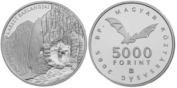
Imre Vass Cave EarthCache
-
Difficulty:
-

-
Terrain:
-

Size:  (other)
Please note Use of geocaching.com services is subject to the terms and conditions
in our disclaimer.
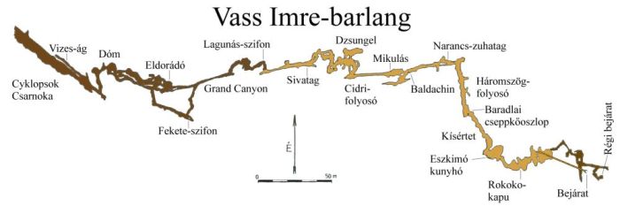
The entrence of the cave is near the Papp Ferenc Research Station at 273 metres above sea level. The cave was formed in Triassic limestone and dolomite. Its length 2200 metres and its vertical extension is ??? metres. The hydrology of the temporarily active stream cave is not fully known, but there seems to ben a connection even with the ??? Cave in Slovakia in a 4,5 km distance. The meandering passage was formed by the underground stream, following NW-SE fault line. At places there are three distinct cave levels. The most common speleothems are flowstones, sodastraws, draperies, and the eccentrics (helictites). The cave has been strictly protected since 1982.
The Budapest Technical University Caving Group explored the underground system in 1954-55 by digging the flood spring area. The present terminal point is blocked by debris. The Research Station and the Papp Ferenc Caving Group were collecting data on the geology, mineralogy, meteorology and hydrology of the cave of decades. The first 300 metres of the main branch are developed and can be visited up to the Lagoon siphon. The guided tours are limited to 10 people at a time. Further parts of the cave require technical equipment and permit issued by the Aggtelek National Park.

The tour starts even with one participant, but in order to protect the cave, the number of visitors is limited to 10 persons at a time.
Tickets are available at the starting place of the tours:
Josvafö Ticket Offi ce – Josvafö, Tengerszem oldal 1. contact
To log yor visit, please.
Send your answers via e-mail to me...
Please don’t give answers in your log !
1, How many metres at the vertical extension ?
2, What is the name of Slovakian cave, which is connected to ?
If you want you can upload a photo with you and/or your GPS in the background with the cave entrance !
Free Hungarian GPS unit digital map means 'hiking trail' (túristatérkép) program from here downloadable.
-----------------------------------------------------------------------
A Papp Ferenc Kutatóállomás közvetlen közelében, 273 m tszf. magasságban nyíló rendszer triász idoszaki mészkoben és dolomitban alakult ki, hossza 2200 m, függoleges kiterjedése ??? m. Az 1982 óta fokozott védelem alatt álló, idoszakosan aktív patakos barlang hidrológiai összefüggései még nem teljesen tisztázottak, egyes feltételezések szerint kapcsolatban áll a 4,5 km távolságra, Szlovákiában található ??? -barlangal is. A patak által kialakított kanyargós (meanderezo) járatok az alapközet ÉNy-DK irányu töréseit követik, helyenként ketto vagy három szintet is alkotva. A folyosokat változatos formáju, méretü és szinü ásványkiválások diszitik, leggyakoribb a cseppköfolyás. A különlegesebb formák közül a szalmacseppkövek, csavart cseppközászlok és a görbe cseppkövek (heliktitek) gazdagsága érdemel említést.
A felszin alatti rendszert a Budapesti Müszaki Egyetem Barlangkutato Csoportjának tagjai 1954-55-ben az árvizi forrászsáj megbontásával, több szakaszban tárták fel. Végpontján a továbbjutást omlás zárja le. A barlangban több évtizeden át közet- és ásványtani, meteorologiai, valamint hidrologiai megfigyeléseket végeztek a kutatoállomás dolgozoi és a Papp Ferenc Barlangkutato Csoport tagjai. A föág közel 300 m hosszu szakasza a Lagunás szifonig kiépitett, 10 fös csoportokban szakvezetö kiséretében látogathato. A további járatok megtekintéséhez alapfelszerelés, mászotudás és a Nemzeti Park engedélye szükséges.
A túrán résztvevok maximális létszáma a barlang védelme érdekében 10 fo.
Túraindulás és jegyváltás:
josvaföi barlangpénztár – Josvafö, Tengerszem oldal 1. kapcsolat
A logoláshoz kérlek…
Küldd el a válaszokat számomra e-mailben...
Kérlek, ne adj meg választ a logban !
1, Hány méter a függöleges kiterjedése ?
2, Mi a Szlovák barlang neve, amihez kapcsolodhat ?
Ha van kedved tölts fel fotót magadról és/vagy a GPS-edröl, a barlang bejáratával a háttérben !

Additional Hints
(Decrypt)
[ ENG : ] Vasb gnoyr ba gur fcbg
[ HUN : ] vasb gáoyn n urylfmvara