Kamlungeforsen


Kalix älv
eller i dagligt tal Kalixälven, är en av de fyra stora älvarna i Norrland, som är opåverkad av vattenkraftverk. Den är 461 kilometer lång, flyter upp från Kebnekaisemassivet i Kiruna kommun. I sydost rinner den genom Lappland och i söder genom Norrbottens län, utlopp i Bottniska viken sydost om Kalix.
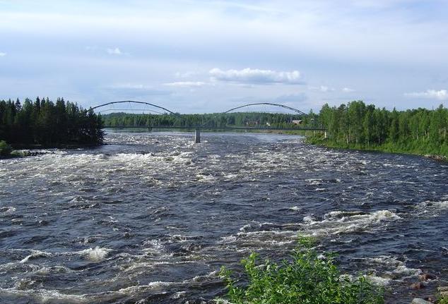
En Fors
Är en hydrologisk funktion mellan en lugnt flytande del av en älv och en kaskad. En fors kännetecknas av att älven blir grundare och att stenar exponeras över vattenytan. När vatten strömmar och stänker över och runt stenarna, blandas luft med vatten och bildar en vit färg kallas "Whitewater". Forsar förekommer när bergmaterialet är mycket resistent mot eroderande krafter jämfört med materialet nedströms forsen. Mycket unga forsar flödar som över fast berg kan kallas forsar för hela sin längd. Fyra faktorer, enskilt eller i kombination, skapar forsar: lutning, avsmalning, hinder och flöde. Gradient. Avsmalning och hinder är älvbottens topgrafiska faktorer och är relativt likartade. Flöde är beroende av både säsongsmässiga variationer i nederbörd och snösmältning.
Älvbottens topografi
Är den viktigaste faktorn för att skapa forsar, och är oftast konsekvent i tiden. Ökat flöde, kan vid en översvämning eller hög nederbörd göra permanenta förändringar i älvbotten genom att tränga undan stenar och klippblock, genom deposition av avlagringar eller genom att skapa nya fåror för vatten.
Lutning
Lutningen på älven är den takt med vilken älven förlorar höjd längs sitt lopp. Denna höjsminskning bestämmer älvens lutning, och till stor del flödet. Flacka lutningar genererar mjuka, långsamma älvar medan branta lutningar skapar störtfloder.
Avsmalning
Bildar ett snabbt flöde när vattnet tvingas in i en smalare kanal. Detta tryck gör att vattnet rinner snabbare och reagerar olika på älvbottens hinder.
Hinder
En sten eller avsats i mitten av en älv eller nära sidan kan hindra flöde, och kan också skapa en "kudde" där älven flyter tillbaka mot sig själv kanske tillbaka under avsatsen. Ofta med fruktansvärda resultat för den som fångats i älven. Om flödet passerar bredvid hindret, skapas en virvel bakom hindret.
Flödet
En markant ökning eller minskning av flödet kan skapa en fors där det tidigare inte fanns någon, "tvätta" fram en fors eller göra en tidigare säker passage svårare eller omöjligt. Flödet mäts vanligen i kubikmeter per sekund.
För att logga:
För att få logga denna  (Earthcache) som
  (found) skall följande uppfyllas:
Valfritt (men önskat!): Ta ett kort på dig med din GPS i handen med forsen i bakgrunden.
Svara på följade frågor och maila cacheägaren svaren:
1. Vilka faktorer bidrar till denna fors?
2. Kasta i ett löv i vattnet och uppskatta flödets hastighet. (m/s)
3. Beskriv strandområdet vid den besökta platsen ur geologisk synpunkt (Material, grovlek mm).
Du behöver inte vänta på godkännande av cacheägaren för att få logga som found. Om jag behöver kompletterande uppgifter hör jag av mig. Kom ihåg att bifoga en bild och att inte skriva svaren i din logg!
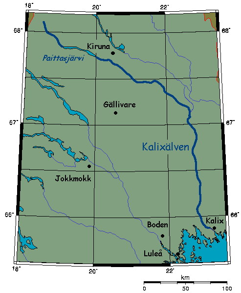

The Kalix River
In Swedish: proper Kalix älv or in everyday language Kalixälven) is one of the four major rivers of Norrland, northern Sweden, that are untouched by water power constructions. It is 461 kilometres long, flowing up from the Kebnekaise mountain range in Kiruna Municipality. In the southeast it flows through Lappland; and to the south through Norrbotten County, discharging in the Gulf of Bothnia south-east of Kalix.
A Rapid
Is a hydrological feature between a smoothly flowing part of a stream and a cascade. A rapid is characterised by the river becoming shallower and having some rocks exposed above the flow surface. As flowing water splashes over and around the rocks, air bubbles become mixed in with it and portions of the surface acquire a white colour, forming what is called "whitewater". Rapids occur where the bed material is highly resistant to the erosive power of the stream in comparison with the bed downstream of the rapids. Very young streams flowing across solid rock may be rapids for much of their length Four factors, separately or in combination, can create rapids: gradient, constriction, obstruction and flow rate. Gradient, constriction and obstruction are streambed topography factors and are relatively consistent. Flow rate is dependent upon both seasonal variation in precipitation and snowmelt and upon release rates of upstream dams.
Streambed topography
Is the primary factor in creating rapids, and is generally consistent over time. Increased flow, as during a flood or high rainfall season can make permanent changes to the streambed by displacing rocks and boulders, by deposition of alluvium or by creating new channels for flowing water.
Gradient
The gradient of a river is the rate at which it loses elevation along its course. This loss determines the river's slope, and to a large extent its rate of flow. Shallow gradients produce gentle, slow rivers while steep gradients are associated with raging torrents.
Constriction
Can form a rapid when a river's flow is forced into a narrower channel. This pressure causes the water to flow more rapidly (hence the name) and to react differently to riverbed events (rocks, drops, etc.).
Obstruction
A boulder or ledge in the middle of a river or near the side can obstruct the flow of the river, and can also create a "cushion" where the river flows back on itself perhaps back under the drop. Often with fearful results for those caught in its grasp. If the flow passes next to the obstruction, an eddy may form behind the obstruction although eddies are typically sheltered areas where boaters can stop to rest, scout or leave the main current, they may be swirling and whirlpool-like.
Stream flow rate
A marked increase or decrease in flow can create a rapid where previously wasn't one, "wash out" a rapid (decreasing the hazard) or make safe passage through previously-navigable rapids more difficult or impossible. Flow rate is typically measured in cubic metres per second.
How to log:
To log this (Earthcache) as (found) you must do the following:
Optional: (but wanted!) Take a picture of yourself with your GPS in your hand and the rapids in the background.
Answer the following questions and mail the answers to the cacheowner:
1. Which factors contribute to this rapid
2. Throw a leaf in the water and estimate the velocity. (m/s)
3. Describe the shorearea at the site from a geological point of view (Material, size, etc).
You do not need to wait for approval from the cacheowner to log as found. If I need additional information, I let you know. Remember to post a picture and not to write answers in your log!
Visit my other Earthcaches:
Sweden:  Svedsmossen Earthcache Ersdalen Earthcache Svavelbruket Rosenlunds bankar Gautelfr Kalkbrottet Druim
Cape Verde: As dunas de Bubista
Montenegro: Vapnenac
Croatia: Kolac natural arch
Cuba: Mirador de Bacunayagua
Greece: Afantou beach
Italy: Torre pendente di Pisa