Teide National Park
Introduction
Teide
National Park (El Parque Nacional del Teide) is a World Heritage
site located in the Canary Islands of Spain from 28° 09' 00" to 28°
20' 00"N by 16°29' 00" to16°44' 00"W. Teide on the island of
Tenerife is the highest mountain in Spain and at 7,500 meters (m)
above the sea floor, is the world's third largest volcanic
structure. It is a shield volcano that combines a severely
beautiful landscape, often wreathed in cloud, with a great variety
of volcanic features with uncommon altitude-adapted endemic flora
and invertebrate fauna. It has been long studied. The high
unpolluted location makes it a natural laboratory for astrophysical
research, for monitoring climatic change and global atmospheric
pollution in addition to the study of the geological processes
which created it.
Altitude
1,650 m-3,718 m (Teide, 3,134 m Pico Viejo).
Physical Features
Teide is
the highest mountain in Spain, an impressive stratovolcano in the
center of the island of Tenerife, the largest of the Canary
Islands, a chain formed like the Hawaiian Islands by the passing of
the under-lying lithospheric plate across a magma plume. The
nominated core and associated protected areas cover over a third of
the island. Its peaks of Teide and Pico Viejo rise 1,700 m and
1,340 m respectively from the encircling 16 km-wide caldera of the
huge ancient Las Canadas volcano, which erupted violently 200,000
years ago. The present volcano which is the third highest in the
world after Mauna Loa and Mauna Kea, rises 7,500 m from the ocean
floor and was created over a long period by a low-intensity
magmatic hot spot beneath an almost stationary tectonic plate. It
is of great scientific interest because it concentrates in a
palimpsest of successive eruptive and effusive landscapes a wide
range of geological and magmatic features characteristic of such
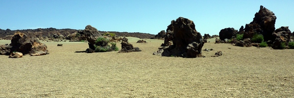
mid-plate oceanic islands. Most notable is the vast caldera of Las
Canadas (the springs) created by a landslide, floored at the 2,000
m level by lava fields, walled by a 600 m escarpment of
multicolored rocks, overlaid on the north side by the high volcanic
summits rising out of it. The crescent-shaped floor of the caldera
teems with a network of smaller volcanic mouths, cones, domes, lava
channels, dikes, lavas from light felsic flows to viscid red lavas
and black obsidian blocks, ochre plains of sandy alluvial deposits
and red and black volcanic ejecta, scoria, lapilli and pumice, from
a long series of basaltic effusions. They form the most varied
collection known of volcanic structures, forms and detritus. The
rocky soil is droughty but nutrient- and mineral-rich, and of many
colors, in one place, Los Azulejos, greenish in cast. Under the
intense sunlight the harsh red-brown desertic coloring streaked
with basalt and, in season, bright with flowers, are very
striking.
Visitors and Visitor
Facilities
In the
last decades of the 19th Century Teide became one of the first
nature geo-tourism centers with the construction of the Altavista
Refuge at 3,270m specifically for ecotourism (now reconstructed,
with 60 beds). Now, there are about 3.5 million tourists a year,
making it one of the most visited volcanoes in the world. Visitors
are channeled through two educational programs: a Regulated
Education program for scientists and a Public Use program served by
a network of facilities and equipment, with guided tours for the
public, educational lectures and school tours, training tours and
environmental workshops. There are visitors' centers at the Parador
de Las Cañadas del Teide hotel (Cañada Blanca) and at El Portillo
which has a botanic garden of endemic plants and a fire and first
aid station. There are also mountain refuges, several restaurants,
a cable car with stations at 2,350 m and 3,550 m and a
communications relay station. In addition to hiking, there are
camping, climbing, caving and bike tours. The Park Service runs the
educational Muñoz Nature Activities center just outside the
Park.
This is an extract from the information on "The
Encyclopedia of Earth" Website. For further reading please see the
full article here.
Minas de San Jose

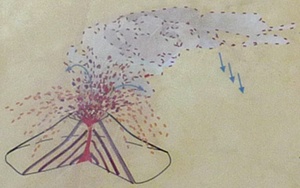
The
pumice banks at Minas de San Jose come from the Montaña Blanca
volcano, located to the southeast of the Teide-Pico Viejo complex.
Its eruptions, very violent at first, sent fragments of pumice
stone flying to great altitudes. It was then deposited in the
surrounding area or blown by the wind to other areas, depending on
its weight.
In the middle of the 20th
Century the roads to the mines were asphalted, which allowed
for a more intensive exploitation of the natural resources.
Various open air mines were created to extract pumice stone which,
due to its characteristics, has many applications like
construction, cosmetics, dentistry and various chemical processes.
In horticulture it is used in diverse crops, as well as in green
houses, golf courses, gardens, etc.
These mines, however, had a
heavy impact on the terrain. The legal reclassification of the
National Park in 1981 led to a greater focus on conservation and
the enormous public pressure forced the suspension of the mining
activity and the restoration of the environment of the area,
as well as that of Montaña Blanca.
Pumice is
composed of highly microvesicular glass pyroclastic with very thin,
translucent bubble walls of extrusive igneous rock. It is commonly,
but not exclusively of silicic or felsic to intermediate in
composition (e.g., rhyolitic, dacitic, andesite, pantellerite,
phonolite, trachyte), but basaltic and other compositions are
known. Pumice is commonly pale in color, ranging from white, cream,
blue or grey, to green-brown or black. It forms when volcanic gases
exsolving from viscous magma nucleate bubbles which cannot readily
decouple from the viscous magma prior to chilling to glass. Pumice
is a common product of explosive eruptions (plinian and
ignimbrite-forming) and commonly forms zones in upper parts of
silicic lavas. Pumice has an average porosity of 90%, and initially
floats on water.
At the published coordinates,
you can see Pumice and also other rocks corresponding to different
stages of the eruptions:
| The Rocks Comprising the
Wall |
 |
Pumice layers
The layers of pumice are made up of fragments of very porous lava
that were hurled very high into the air during eruptions with a
high gas content. |
|
Agglutinates
When the magma contains less gas and the eruption is less violent,
the lava is no longer porous, rises less high and is still molten
when it falls and welds together. |
 |
|
 |
Lava flows
Finally, when practically no gases remain, the lava flows over the
erupting vent like an incandescent river. |
Logging
Requirements
Before
logging, take a look at the info boards in the posted
Earthcache and Parking coordinates and send us an e-mail with the
answers to the following questions:
- On your way to the
Earthcache location you walk on pumices. What is the average
dimension of these pumices? (If you're not good at estimating
dimensions, look at the pumice depicted in the lower left corner of
the infoboard at the Parking location)
- On the infoboard at the
Earthcache location, what's the name of the Mountain that is
furthest to the right?
The above information was
compiled from the following sources: