Konglomerat im Rurtal

Begebt Euch zu den angegebenen Koordinaten. Parken könnt Ihr bei:
N 50 41.679 E 006 28.450
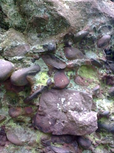
Konglomerate sind weltweit verbreitet. Man trifft sie prinzipiell in den gleichen Situationen wie Sandsteine an. Auf Grund der hohen Transportenergie, die für die Ablagerung von Geröllen nötig ist, sind sie aber deutlich seltener als Sandsteine. Auch treten Konglomerate in relativ ruhigen Ablagerungsgebieten (z. B. im Meer bei größerer Entfernung von der Küste oder in den Tiefländern der Kontinente) nicht auf. Ihr Vorkommen in marinen Ablagerungen ist daher ein Indiz für Küstennähe, auf Festländern ein Beleg für Gebirgsbildungsphasen. Konglomerate findet man am gesamten Alpenrand sowie an den Flüssen des Alpenvorlandes, u. a. in Deutschland auch in der Nord-Eifel in der Nähe von Nideggen aus der Zeit des Trias.
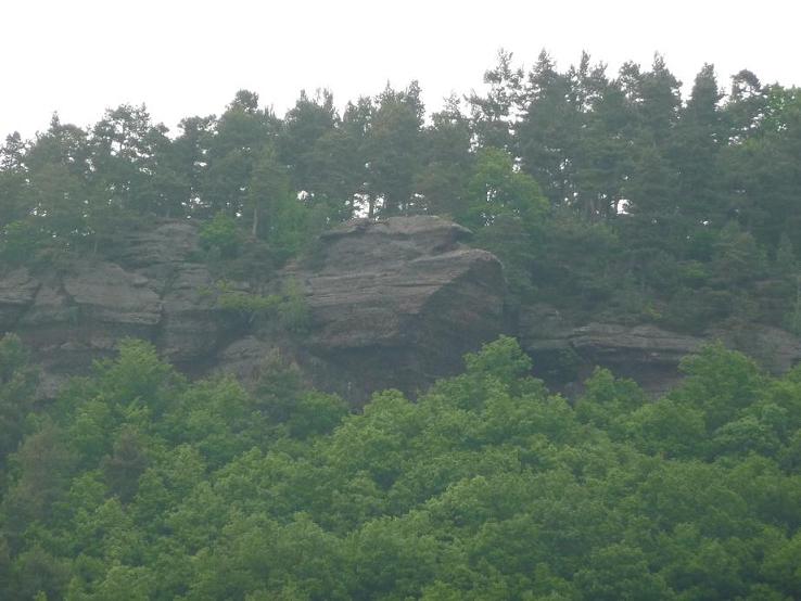
Die typische Dreiteilung der Gesteinseinheiten der Trias im Germanischen Becken ist in den Alpen nicht zu erkennen. Der Buntsandstein ist im Rurtal besonders stark verfestigt, so dass hier der Sandstein über der Rur bei Nideggen bis zu 50 Meter hohe senkrechte Felsklippen, türme und -wände bildet. Durch die Verfestigung ist der Buntsandsandstein im Rurtal außerordentlich standfest.
Petrographische Beschreibung:
Mittelsandiger und fein- bis mittelporiger Sandstein. Schräggeschichtet, bisweilen auch kreuzgeschichtet. Konglomeratische Lagen mit Geröllgrößen bis 8 cm treten gelegentlich auf.
Mineralbestand:
Komponenten 80 %, Bindemittel 4 %, sichtbarer Porenraum 16 %.
Komponenten:
Quarz 86 %, Gesteinsbruchstücke 13 %, opakes Erz und Schwerminerale 1 %.
Bindemittel:
fast ausschließlich kieselig, geringer toniger Anteil, zum Teil eisenschüssig.
Der Name Trias wurde 1834 von Friedrich von Alberti nach der in Mitteleuropa auffälligen Dreiteilung Buntsandstein, Muschelkalk und Keuper vorgeschlagen und fand rasch Akzeptanz in der geologischen Literatur. Diese klassische Dreiteilung ist jedoch nur im Germanischen Becken ausgebildet. Entsprechend werden die drei Abteilungen der Germanischen Trias heute nur noch als lithostratigraphische Einheiten aufgefasst. Nach der international gültigen Untergliederung der Trias werden zwar ebenfalls drei Serien unterschieden: Unter-, Mittel- und Obertrias (bzw. Untere, Mittlere und Obere Trias), deren Grenzen jedoch nicht mit den lithostratigraphisch definierten Grenzen von Buntsandstein, Muschelkalk und Keuper übereinstimmen.
Die hier gezeigten Felsformationen bieten einen atemberaubenden Blick auf das enge Rurtal und werden von Wanderer und Naturfreunde gleichermaßen geschätzt. Auf der Oberfläche wachsen seltene Moose und Flechten. In den Nischen sind auch vereinzelt Kiefern anzutreffen. Bislang wurden 85 verschiedene Flechtenarten an den Felsen des Rurtales nachgewiesen.
Bitte macht optional ein Foto von euch ODER eurem GPS (mit sichtbaren Koordinaten) und fügt es eurem Log-Eintrag hinzu.
Außerdem schickt mir eine Mail mit folgenden Angaben:
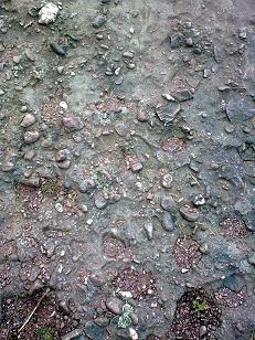
1.) Schaut euch am Aussichtspunkt den Sandstein zu euren Füßen einmal genau an. Wie groß sind die Einschlüsse im Gestein?
2.) Hier wurde in früheren Zeiten ein Mühlstein aus dem Fels gebrochen. Welchen Durchmesser hatte er? Vermesst dazu die kreisrunde Vertiefung im Bereich des Aussichtspunktes.
3.) Wie unterscheidet sich das Gestein am Aussichtspunkt zu dem Gestein neben dem Geländer ?
4.) Beschreibt die Zusammensetzung des Konglomerates neben dem Geländer?
5.) In welchem Zeitalter entstand das Konglomerat ?
Danach könnt Ihr sofort loggen. Wenn irgend etwas nicht in Ordnung sein sollte, melden wir uns.

Also in English:
The conglomerate rock by Rurtal
Now go to the given coordinates.
Parking at: N 50 41.679 E 006 28.450
Conglomerates are world-wide common. One finds it in principle in the same situations as sandstones. Due to the high transportation energy they are however clearly rarer than sandstones. This high energy is necessary for the deposit of rubble. Also conglomerates in relatively calm deposit areas do not arise (for example in the sea with larger distance of the coast or in the low countries of the continents). Their occurrence in marine deposits is therefore an indication for proximity to the coast, on mainlands a voucher for mountain formation phases. One finds conglomerates at the entire alpine edge as well as at the rivers of the Alpine Foothills. Among others in Germany also in the North Eifel in the near of Nideggen from the time of the Triassic.
The typical three-division of the rock units of the Triassic in the Germanic basin is not to be recognized in the alps. The colored sandstone is very strongly solidified in the Rurtal, so that here the sandstone in top of the Rur near Nideggen has formed rock cliffs, towers and walls up to 50m vertically. On the basis of this solidification the colored sandstone is extraordinarily stable.
Petrographic description:
Size of sand is in the middle and fine to centralporous sandstone. Diagonal-laminated, sometimes also cross-laminated. Konglomerati situations with rubble sizes to 8 cm arise occasionally.
Mineral constituent:
Components 80%, cement 4%, visible pore area 16%.
Components:
Quartz 86%, rock fragments 13%, opakes ore and heavy minerals 1%.
Cement:
almost pebble stone, small clay portion, partially iron mineral including.
The name Trias was suggested to 1834 by Friedrich of Alberti after the three-division new red sandstone, shelly limestone and Keuper remarkable in Central Europe. Rapid he found acceptance in the geological literature. This classical three-division is trained however only in the Germanic basin. The three departments of the Germanic Triassic are only understood accordingly today as lithostratigraphische units. According to the internationally valid subdivision of the Trias likewise three series are differentiated (respectively Lower-, Middle- and Upper Triassic ). But the borders do not agree however with the lithostratigraphic defined borders of new red sandstone, shelly limestone and Keuper.
The rock formations shown here offer a breath-robbing view of the close Rurtal and become equally estimated from Wanderer and nature friends. On the surface rare moose and lichens grow. In the niches are also isolate pine-trees to find. So far 85 different kinds of lichen were proven to rock of the Rurtal.
I would be very happy for a picture of you at this location. But this is of course not mandatory. To log this cache successfully, please answer the following questions and mail the answers to us:
</ b>
1) Check out the sandstone exactly at your feet at the lookout. How large are the inclusions in the rock?
2.) Here was broken a millstone out of the rock in ancient times. What is the diameter? Make a measure to the circular depression in the area of the viewpoint.
3.) What is the difference of the rocks next to railing and at the viewpoint?
4.) Describe the composition of the conglomerate next to railing ?
5.) In which earth age did this conglomerate develop?
After that you can give your log directly. If anything is not ok, we will conntact you.