CZ
Sopka Velký Roudný
(780,1 m n. m.) je typickým stratovulkánem (smíšenou sopkou). V jeho stavbe se strídají produkty efuzivní (výlevné) a explozivní vulkanické cinnosti, tj. lávy a vulkanoklastika. Ve vrcholové cásti kuželu jsou ve výchozech odkryty cedicové horniny sopouchu, zejména s fialove šedou, silne pórovitou lávou, vzácneji se sopouchovou brekcií. Jsou též zachovány k západu a k severu smerující pocátecní úseky lávových proudu, tvorené kompaktním cedicem precházejícím do porézních láv s balvanitým rozpadem. Úbocí stratovulkánu jsou pokryta vulkanoklastickými vyvrženinami - tufy - které jsou odkryty nejen v nekolika malých lomech. Hrbet, smerující od vrcholu severoseverozápadním smerem, je patrne pozustatek parazitického kuželu.
K vulkánu náleží ctyri výrazné lávové proudy, které presahuji hranice chráneného území. Smerem k severu mírí krátký proud Mlýna Roudná (délka 0,7 km, mocnost 15 m), k severovýchodu proud Heroldova Mlýna o délce 1,3 km a mocnosti 30 m. Nejdelší, pres 5 km dlouhý, je proud Chribského lesa, smerující na východ ke Slezské Harte. Má složitejší stavbu pocházející z nejméne dvou oddelených výlevu, dosahuje mocnosti pres 50 m a zcásti vyplnuje bývalé koryto Moravice. Ješte složitejší a nedostatecne prozkoumanou stavbu (zahrnující polohy vulkanoklastik) má k jihovýchodu vybíhající hrbet, nazývaný proud Cerného lesa. Nelze vyloucit, že se jedná o starší vulkanické centrum sopky Výlevné cedicové horniny jednotlivých proudu mají ponekud odlišné petrografické složení. Náležejí do asociace alkalický (viz.úkol 2b/) cedic - nefelinický bazanit - olivinický nefelinit -limburgit. Magma ke svému výstupu využilo oslabené zóny na krížení zlomu severozápadního-jihovýchodního smeru a šternbersko-hornobenešovské zóny, která je úzkým, tektonicky stlaceným pásmem devonských sedimentu a vulkanitu v kulmské formaci hornobenešovského souvrství. Radiometricky zjištené stárí cedicu prokázalo nekolik fází aktivity vulkánu v období spodního pleistocénu. Stárí vzorku odebraného z „proudu" Cerného lesa ciní cca 2,5 miliónu let, zatímco u vzorku z proudu Chribského lesa jen 1,4 miliónu let.
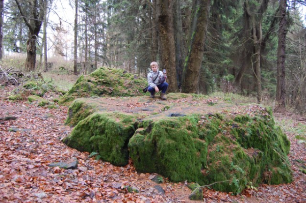
Na úpatí sopky se nachází Boží nebo certuv kámen. Stolový kámen je z pyroklastické hmoty (z reckého pýr = ohen) tufu, který vznikl zpevnením cástic vyvržených sopkou. K rozlomení bloku došlo pri dopadu cedicové sopecné pumy pri explozi vulkánu, po které zustala nepravidelná prohloubenina, pripomínající lidskou šlépej. V prohlubni se i v suchém období udržuje voda, která vzniká bud kondenzací vodních par následkem rozdílu teplot uvnitr a vne, nebo sem vzlíná porézní horninou.
Povest
praví že, z Roudenska se za dávných casu, kdy ješte Pán Buh chodil po zemi, usadili na Velkém Roudném certi. Rozhazovali kolem žhavé balvany a dštili síru (zjevná reminiscence na puvod hory), a mezi lidem šírili bezbožnost. Zbožní lidé si vymodlili príchod Pána Boha, který se rozhodl bojovat se samotným pánem pekel Luciferem.
Pretahoval se s ním na kameni (stolový kámen), kde šlépej vpravo predstavuje otisk boží nohy a údajné škrábance drápy dábla. Buh zvítezil a mrštil dáblem do zeme, za nímž naskákali všichni certi. Dírou, ve které certi zmizeli, má být puvodní jícen sopky na severozápadní strane kopce tesne pod vrcholem, která byla pro jistotu zaházena balvany, aby pekelná pakáž nevylezla.
Povesti a pohádky, stejne jako písne, jsou pokladem folklóru - lidové slovesnosti.
Úkoly:
1. (nepovinné) do logu mužeš priložit fotografii tebe s GPS, nebo pouze GPS u stolového kamene
2. na tento E-mail pošli:
a/ namerenou nadmorskou výšku (použijte vaší GPS) tohoto Stolového kamene a obvod v metrech u základny.
b/ vysvetli jak vzniká stratovulkan a co je to parazitický kužel?
c/Nepovinné: kde se v ČR nachází ložisko nefelinického bazanitu ?
Zdroj informací www.rymarovsko.cz
EN
Volcano Big Roudny
(780,1 m n. m.) is a typical stratovolcano (a volcano mixed). In the construction of products take turns products of volcanic activity ( effusive ) and explosive volcanic activity ( lava and volcanoclastic ). In the top of the cone are uncovered outcrops of basaltic rocks flue pipe, especially purple gray with very porous lava, rarely with breccia the flue pipe. They are also preserved the original sections of the lava flows pointing to the west and north towards which are formed a compact basalt pass into the lavas with boulder collapse. The hillside of stratovolcano is covered volcaniclastic ejecta - tuff - which are discovered only in several small mines. Back side of stratovolcano which is pointed to the top north-north-west direction is probably a remnant of the parasitic cone.
The volcano is comprises four major lava flows, which go beyond the boundaries of the protected area. Heading north is located short flow Mill Roudna (length 700 metres, thickness 15 meters in the northeast it is the Herold´s Mill with length 1300 metres and thickness of 30 meters. The longest flow ( over 5000 meters long ) is the flow of Chribsky forest which is pointed to east to Silesia Hart. It has a more difficult structure derive from at least two separate outbursts and it reaches a thickness of 50 metres. It fills former trough Moravice partially Much more difficult and poorly explored building (including position of volcaniclastic) is ridge running out to the southeast which is called the Flow of Black Forest. It is possible that it is an older volcanic center of the volcano. Effusive basalt rocks of the individual flows are different petrographic compositionThey belong to the association of alkaline (viz.úkol 2b /) basalt - nepheline basanites - olivine-nefelinit limburgit. For output of magma was used weakened zone which crosses the northwest-southeast direction and Šternbersko-hornobenešovské zone. This is narrow, tectonically compressed zone of the Devonian sediments and volcanic rocks of the Culm formation hornobenešovská zone. Radiometrically determined age of the basalt showed several phases of volcanic activity in the lower Pleistocene. The age of the sample taken from the Flow of the Black Forest is about 2.5 million years, while a sample of Chribsky forest is only 1.4 million years.
At the foot ofthe volcano there is God or the Devil's Stone
The Stone Desk is made of pyroclastic material (from the Greek pyr = fire) tuff, which was formed hardening particles ejected by the volcano. To break the block occurred at volcanic explosion, which left irregular sag resembling a human footprint. Water keeps in the hollow pits as well in dry periods which is obtained either by condensation due to temperature difference between inside and outside and here rises porous rock.
Legend
says that devils settled Velký Roudný in ancient time when God walked around the earth. They scattered burning rock around them and spread religion among civilization. Religious people pray coming of the Lord God who has decided to fight the lord of hell Lucifer himself.
Dropped with him on the stone (stone table) where footprint in the right side is a footprint of God leg and in the near by alleged scratches claws of Lucifer. The God won and chucked Lucifer into the ground, other devils jumped by him.
Hole in which the devils vanished, is original throat of the volcano on the northwest side of the hill just below the summit, which was for sure filled up boulders in order to infernal vermin didn´t get out.
Myths and fairy tales, as well as songs, are the treasure of local folklore
The tasks:
1.( voluntary ) in the log you can attach a photo with the GPS, or GPS, the only stone table
2. Send E-mail with answer of these:
a/ elevation of the stone table in meters ( use your GPS ) and the circumference at the base of stone
b/How stratovolcano was formed and what is it parasitic cone?
c/Optional: where is the nepheline basalt deposit located in the Czech Republic?
Every answer you can find on the info desk which is near parking area.
Source of information www.rymarovsko.cz