The bridge sidewalk is not very wide. If you prefer to make your observations from one end of the bridge or the other, rather than from the middle of the bridge, that's perfectly fine. Parents, please keep an eye on your children if you cross onto the bridge.
A fall line (or fall zone) is a geologic unconformity between an upland region of continental bedrock and an alluvial coastal plain. Fall lines are particularly evident when crossed by a river, for there will often be rapids or waterfalls as the water drops down over the exposed basement rock to get to the flatter coastal plain. As time goes on, a fall line can recede upstream as the river erodes the uphill dense material, forming c-shaped waterfalls.
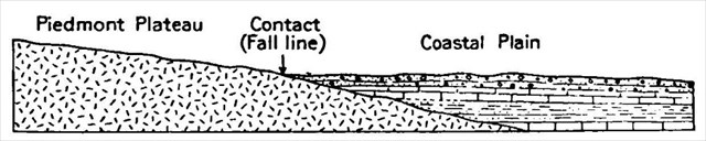
In the United States, the fall line occurs between the Piedmont (the foothills of the Appalachian Mountains) and the Coastal Plain. That line extends from right here in Alabama east to Georgia, then up the East Coast to New Jersey. In some areas the fall line appears as a cliff or bluff, but in other areas it isn't as pronounced. Based on current scientific theory, the fall line is the ancient shoreline of the Atlantic Ocean (Mesozoic era -- the Age of Dinosaurs). It separates Upper Coastal Plain sedimentary rocks to the south from Piedmont crystalline rocks to the north.
The fall line is notable because the geological transition here has impacted early transportation and, therefore, commerce and settlement. The falls that give rise to the term fall line are the shoals or waterfalls caused by the first exposure of crystalline rocks encountered when traveling upstream in rivers of the Coastal Plain. The rapid change in elevation of the water, and the resulting energy release, makes the fall line a good location for water mills, grist mills, and sawmills. Also, prior to the advent of railroads and automobiles, most commercial traffic was by boat. Since the fall line blocked navigation further upstream, and the falls were good places to build mills to use the water power, river ports developed along the fall line.
You can see several differences in the geology north and south of the fall line: different soil types, hydrology, and stream formation. Below the line, the soil is normally sandy; above it, the soils have more clay. Wide floodplains have developed along many of the streams below of the fall line, as the streams are not as contained by the sandy soil. Narrower valleys are present above the fall line, as channels in the rockier basement contain the streams. This also means the fall line separates very different plant and animal communities.

In Alabama, the fall line starts around Columbus, running roughly parallel to Interstate 85 to Montgomery and Wetumpka. From Opelika to Montgomery, where the hard rocks of the Piedmont meet the sands and gravels of the Coastal Plain, there is a visible change in slope, with the Piedmont rocks underlying a plateau that is 150 to 200 feet higher than the Coastal Plain rocks. From Wetumpka to Clanton, the fall line is relatively indistinct, appearing as flat lowlands approximately 10 to 12 miles wide, where the Coosa River eroded away the rock. In the central part of the state, the fall line is a zone about 5 miles wide that consists of narrow, steep-sided valleys with flat higher areas. In most of the northwestern part of the state, the fall line is a slope with an elevation change of about 120 feet and forms where the Coastal Plain meets the resistant sandstones of the Cumberland Plateau.
The Fall Line directly contributed to the modern development of the Montgomery area, particularly towns such as Tallassee and Prattville, and continues to do so today.
LOGGING THIS EARTHCACHE
To log this cache, please do the following:
1. To log this earthcache, email us or send us a message and copy and paste these questions, along with your answers. Please do not post the answers in your log, even if encrypted. There's no need to wait for confirmation from us before you log, but we will email you back if you include your email address in the message. Group answers are fine; just let us know who was with you.
a. The name of this earthcache: Alabama Fall Line Earthcache.
b. Into which body of water does this river flow? (There is more than one right answer for this.)
c. From where you are standing, you should see both historical and modern means of harnessing the energy of the falling water. Name as many as you can.
2. (Optional) Post a photo of you and/or your GPSr in your log.
Sources: Wikipedia, Encyclopedia of Alabama, New Encyclopedia of Georgia