 [PL]
[PL]
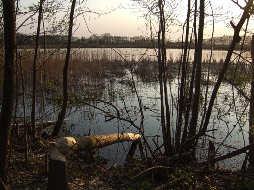
Stawy:
Krzyz - pólnocna dzielnica Tarnowa, która
niegdys byla osobna wsia nalezaca do rodziny Sanguszków. Swój
rozkwit przezywala w XVIII i XIX w. kiedy to Sanguszkowie
wybudowali tu tartak, cegielnie, gorzelnie i karczmy. W polowie XIX
w. na obszarze ok 50 ha wybudowali 20 stawów. Hodowano w nich ryby,
a zima kruszono z nich lód i sprzedawano do okolicznych karczm. Po
II wojnie swiatowej stawy staly sie wlasnoscia Panstwowego
Gospodarstwa Rybackiego a nastepnie przeszly w rece prywatne.
Oprócz wielu gatunków ryb zyjacych w stawach, na ich brzegach
wystepuje wiele ciekawych gatunków roslin i zwierzat. Mozna spotkac
tu wydre, pizmaka oraz bobra. Slady bytnosci tego ostatniego mozna
latwo rozpoznac po zwalonych przez niego drzewach.
Etap 1:
Podane wspólrzedne prowadza w poblize stawów.
Mozna tutaj pozostawic samochód. Na drzewie przymocowana jest
tablica informacyjna.
Na jej dole znajduja sie kolorowe godla. Ich ilosc nazwij
A.
Na pierwszym godle znajduje slonce - policz widoczne tam promienie
sloneczne i liczbe ta nazwij B.
Na ostatnim godle znajduje dwucyfrowa sie liczba - nazwij ja
CD.
Skrytka:
Skrytka znajduje sie przy wspólrzednych:
N 50° 03.DA(A+C) E 020° 58.D(B-C)B
Jest to ok. 5 minut marszu od wspólrzednych poczatkowych.
Pojemnik zawiera logbook, olówek i kilka przedmiotów na
wymiane.
 [EN]
[EN]
Ponds:
Krzyz - a north district of Tarnów that was
formerly a separate village belonging to the Sanguszko family. Its
heyday was in 18. and 19. centuries, when the Sanguszko family
built a sawmill, brickyard, distillery and taverns. In mid 19.
century they built 20 ponds spreading over 50 ha. They bred fish
there and in the winter they crushed ice from there and sold to the
neighbouring taverns. After WWII the ponds became a property of the
National Fisherman Farming and then moved to private hands.
Except many species of fish that live in the ponds, on theirs banks
you can find numerous interesting species of plants and animals.
You can spot an otter, musk-rat and a beaver. The very
characteristic traces of beaver are trees cut and fallen by this
animal.
Stage 1:
Listed coordinates take you near the ponds. You
can leave your car there. There is an information sign fixed to a
tree.
On its bottom there are coloured emblems. Count them and call the
number A.
On the 1st emblem there is a sun - count visible sunbeams and call
this number B.
On the last emblem there is a two-digit number - call it
CD.
The cache:
The cache is placed at coordinates:
N 50° 03.DA(A+C) E 020° 58.D(B-C)B
It's about 5 minutes walk from the initial coordinates.
The container includes a logbook, pencil and items for trade.