Estuário do rio Cávado EarthCache
-
Difficulty:
-

-
Terrain:
-

Size:  (not chosen)
Related Web Page
Please note Use of geocaching.com services is subject to the terms and conditions
in our disclaimer.

What is an Estuary?
An estuary is the thin zone along a coastline where freshwater systems and rivers meet, and mix with a salty ocean, becoming brackish.
Sometimes, freshwater from rivers mixes with large freshwater bodies creating a "freshwater estuary" that functions like a typical brackish estuaries.
Estuaries are unique places that are valuable to the environment and to society.
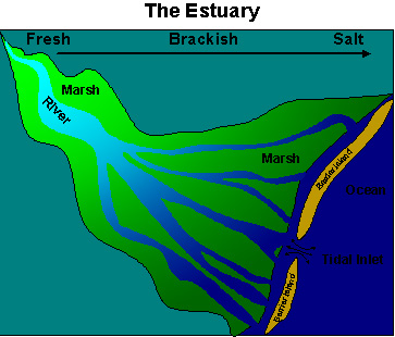
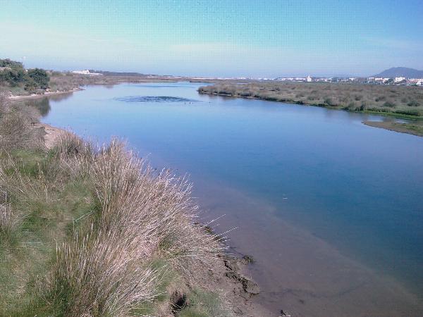
Estuary of the Cávado river
On the north shore, near the town of Esposende, there is a vast area of port infrastructure, fisheries, shipbuilding and recreation, protected by about 2 km from breakage. On the south bank the estuary is separated from the sea by a long sandbank, upstream of which there is a major area of salt marsh estuary. In the coastal area, north of the mouth (tidal inlet) there is a sandy beach and dunes and in the south is common rock formations.
The mouth (tidal inlet) is narrow (about 80 meters) and shallow. In this area the main channel curve at 90 ° west. In the Atlantic Ocean immediately in front of the mouth there is a sand bank that discovers at low tide and hinders the passage of vessels inside the estuary. Within the estuary there are sand banks and small islands, which separate the shallow channels.
The mobility of accumulated sediment in the channel, on dunes and on the sand bank in front of the mouth (tidal inlet) give this region a highly dynamic changes in morphology by intense wave action and tidal currents and due to river discharge.
The tide in Esposende is identical to that in other places along the Portuguese coast. The tide is semi-diurnal, with average amplitudes of about 2 meters and maximum amplitudes just under 3 meters and is spread in the river channel to the zone of Marachão.
The distribution of salinity in the estuary depends primarily on the hydrodynamics and the flow of the river, which determine the residual circulation and residence time. In the case of estuary Cávado (as in other estuaries of northern Portugal), the flow of the river is high (the average is 66 m3 / s) and residual volume, and the residence time is low. As a consequence the estuary has medium low salinity.
The results show that (under these conditions of flow), at low tide fresh water occupies most of the estuary, and that at high tide the salt water penetrates up about half of the estuary. The water leaving the estuary moves northward along the coast.
The estuary of Cávado river is part of the Natural Park of the North Coast

The Cache
To claim is found, first you have to go to the given coordinates that are are from an observation point of the estuary at the end of a elevated boardwalk that run through the estuary and send me an email with the correct answers to the following questions (do not post the answer in your log):
Observe the channel of the estuary that lies along the coordinates and tell me:
[Attention is to watch the channel and NOT the whole estuary.]
[1] What's is width?
[2] Do you consider that the channel is deep or not?
[3] The channel water is affected by the tide?
After receive my mail validating your answers, you must upload a picture to your log, a picture of the estuary (not of the observation point). It is not necessary to see your face or the GPS.
Logs posted without send me the email and receive my mail validating your answers will be deleted, ...

O que é um estuário?
Um estuário é a pequena zona ao longo de uma linha costeira, onde sistemas de água doce e rios se encontram e misturam com o oceano salgado, tornando a água salobra.
Às vezes, a água doce dos rios mistura-se com grandes massas de água doce criando um “estuário de água doce”, que funciona como um típico estuário de água salobra.
Os estuários são lugares únicos que são valiosos para o ambiente e para a sociedade.
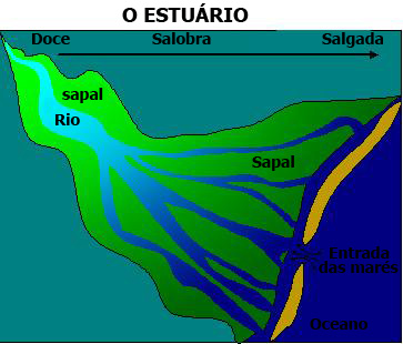
Estuário do rio Cávado
Na margem norte, junto à Vila de Esposende, existe uma vasta área de infra-estruturas portuárias, pesqueiras, de construção naval e recreativas, protegida por cerca de 2 km de quebra. Na margem sul o estuário é separado do mar por uma longa restinga, a montante da qual existe a principal área de sapal do estuário. Na zona costeira, a norte da embocadura existe uma praia de areia e a sul da restinga são comuns formações rochosas.
A embocadura é estreita (cerca de 80 metros) e pouco profunda. Nesta zona o canal principal curva a 90º para Oeste. No oceano Atlântico, imediatamente em frente à embocadura existe um banco de areia que descobre em baixa-mar e dificulta o acesso de embarcações ao interior do estuário. No interior do estuário existem bancos de areia e pequenas ilhas, que separam canais de baixa profundidade.
A mobilidade dos sedimentos acumulados no canal, na restinga e no banco em frente à embocadura conferem a esta região um grande dinamismo com alterações intensas da morfologia por acção das ondas e das correntes de maré e devidas à descarga do rio.
A maré em Esposende é idêntica à registada nos outros portos ao longo da costa Portuguesa. A maré é semi-diurna, com amplitudes médias de cerca de 2 metros e amplitudes máximas um pouco abaixo dos 3 metros e propaga-se no canal do rio até à zona de Marachão.
A distribuição de salinidade no estuário depende essencialmente da hidrodinâmica e do caudal do rio, os quais determinam a circulação residual e o tempo de residência. No caso do estuário do Cávado (como no de outros estuários do norte de Portugal), o
caudal do rio é elevado (o valor médio são 66 m3/s) e o volume residual, bem como o tempo de residência são baixos. Como consequência o estuário tem salinidades médias baixas.
Os resultados mostram que (nestas condições de caudal), em baixa-mar a água doce ocupa a maioria do estuário, e que em preia-mar a água salgada penetra até cerca de meio do estuário. A água que deixa o estuário desloca-se para norte, paralelamente à costa.
O estuário do Cávado faz parte do Parque Natural do Litoral Norte
A Cache
Para reclamar o found tem primeiro que ir até as coordenadas indicadas que são de um ponto de observação do estuário no fim de um passadiço de madeira que precorre o estuário e enviar-me um e-mail com as respostas correctas às seguintes questões (não coloquem as respostas no log):
Observe o canal do estuário que se encontra junto das coordenadas indicadas e diga-me:
[Atençao é para observar o canal e NÃO todo o estuário.]
[1] Qual a sua largura?
[2] Considera que o canal é profundo ou não?
[3] A água do canal é a afectada pela maré?
De pois de ter recebido a minha confirmação, logue o found e coloque uma foto que mostre o estuário (não o ponto de observação). Não é necessário que se vejam as faces de ninguém nem o GPS.
Logs feitos sem me enviar o e-mail com as respostas e ter recebido a minha confirmação serão apagados ...

Additional Hints
(No hints available.)