Gola su Gorruppu EarthCache
-
Difficulty:
-

-
Terrain:
-

Size:  (other)
Please note Use of geocaching.com services is subject to the terms and conditions
in our disclaimer.
Gola su Gorruppu
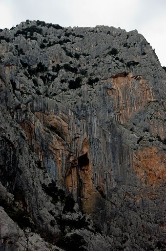
This earthcache takes you to Gola Gorruppu, a huge canyon located in the Supramonte moutains. The Supramonte moutains are largely formed from limestone and thus host a large variety of karst formations. Gorruppu is one of them and forms as well the source of the Riu Fiumineddu, a beautiful river that continues from the canyon through a green valley full of whine and oliv farms into the Lago del Cedrino. This lake is one of the major sources of fresh water in eastern Sardinia.
As most other karst formations, Gorruppu has formed over a long period of time through mildly acidic water acting on soluble bedrock, in this case limestone. The carbonic acid that causes such karst features is formed as rain passes through the atmosphere picking up carbondioxide (CO2), which dissolves in and is transported by the water. Once the rain reaches the ground, it may pass through soil that may provide further carbondioxides to form a weak carbonic acid solution: H2O + CO2 = H2CO3 (the carbonic acid). This is similar to the accid that can be found in soda water. Gorruppu was formed by this water in a continous process. First, the water formed a river bed, but over the centuries, the acid in the river continously digged deeper into the limestone rock, forming the deep canyon that can be seen today.
During this process, occasionally, large boulders would fall from the top of the canyon into it (caused by erosion or earthquakes). These huge boulders (the ones that can be found in Gorruppu range to a diameter of 20m) blocked the path of the water and caused the creation of whitewater and rapids. However, as the canyon it self, the boulders are slowly eaten by the flowing water and they were formed into the caracteristic round and organic surface that they have today.
|
|
The two main water sources of Gola Gorruppu - Water Drains coming down from the moutain (left) and the source cave deep in the canyon (right) |
|
Today, the Riu Fiumineddu, which sources in Gorruppu aquires his water through serveral ways. Water drains can be found in multiple locations within the canyon. They drain the rainfall from the top of the moutain range into Gorruppu. An example for such a drain is shown in the left picture above. Many of these are small canyons themselves but much less developed than the main canyon. The other source of water is a karst grotta located at the very end of the main canyon. This is shown in the right picture above.
Rocks in Gola sa Gorruppu
|
-->How to get to Gorruppu?
The only way to Gorruppu is on feet. A moderate hiking trail to Gorruppu starts at the Sa Barva bridge ( N 40° 13.410 E 009° 30.965) and it will take you two hours (or 7 km) to reach the canyon. To get with the car to Sa Barva bridge, follow the long and small road from Dorgali. It ends at the bridge. |
-->Visiting Gorruppu
Access to the Gorruppu canyon requires a fee to be paid (currently 5 EUR) during high seaon period. While we highly recommend it, it is not necessary to complete the cache. A guided tour of the canyon is included in this fee. However, if you are an experienced hiker with some climbing skills, we highly recommend to explore the canyon on your own. There is much to see, including numerous karst grottas and spectacular water drains, especially deep in the canyon. Getting there requires quite some stamina since you have to climb over huge boulders on the whole way and may need to cross small lakes.
|
-->Logging Requirements
To log the cache, you need to answer the following questions. You can go ahead and log direclty after sending the answers. If there is an issue, I will come back to you.
1) At the entrance to the canyon, you will find a huge boulder, adjacent to the information board (cache coordinates). Note that the coordinates may be some meters of due to relfections from the high walls. How wide and how high do you guess is this rock?
2) How high are the walls of the canyon on their heighest point? and how wide is the canyon at this point? You can ask this information from the guides or try to make a guess yourself.
3) Take a photo of your GPS in front of the information board at the entrance. This is optional, however, for reasons for fairness, please upload a photo.
|
Additional Hints
(No hints available.)