#7 Zanikle obce - Kienheid Traditional Geocache
#7 Zanikle obce - Kienheid
-
Difficulty:
-

-
Terrain:
-
Size:  (small)
Please note Use of geocaching.com services is subject to the terms and conditions
in our disclaimer.
#7 Zaniklé obce - Kienheid
Toto je sedmá cache ze série Zmizelé obce, která vás provede po
obcích a zajímavých místech Chomutovska, které byly postupem casu
opušteny a príroda nad nimi opet prebírá nadvládu. Ke
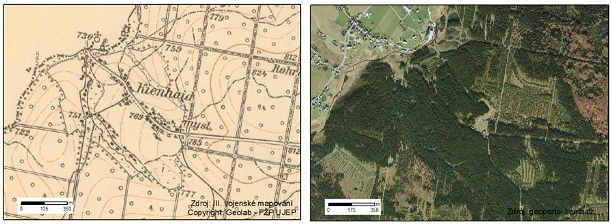
každému místu je priložena podrobná mapa z konce 30. let,
na které mužete porovnat aktuální stav s historií dávno
minulou.
This cache is the seventh one from the series
Disappeared villages. This series will guide you to villages and
interesting places around Chomutov abandoned during the years. For
each place is attached a precise map from the late 30´s which will
help you to compare the history with the present
state.
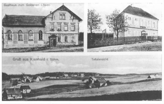 Pohled na obec
Vesnice Kienhaid, které se také ríkalo Kienhaida, ležela na
saských hranicích, 8 km severne od Hory Svatého Šebestiána,
v nadmorské výšce 870 m. Za potokem na saské strane
leží Kühnhaide. Také puvodní název osady na ceské strane byl
roku 1662 Bohmische Khünheyde. Kienhaid patrí mezi tech nekolik
lokalit v našem okrese, o kterých se nedochovaly témer
žádné zprávy. Zdá se, že ceská osada vznikla až po
30leté válce.
Roku 1787 je u Schallera uvádena Bohmische Künheit s 18 domky u
panství Cervený Hrádek. Zdejší podnebí bylo velmi drsné, s
dlouhotrvajícími zimami a promenlivými léty. Obyvatelstvo bylo
chudé, zemedelství ani chov dobytka se zde nevyplácel. Vyrábely se
zde jen drevené krabice a detské pušky.
Také po ukoncení 2. svetové války zustala Kienhaida dlouho jakoby
odríznuta od sveta. Vždyt i správa obce byla prevzata až
10. 12. 1945 a do té doby tam zustalo všechno nemecké
obyvatelstvo. Teprve pak se snažili s rodinami a dobytkem
prejít pres potok do Saska. Bohužel, porádek sem
neprišel zjednat ten správný clovek. Správní komisar, který
tam nastoupil, se dopustil rady omylu. Koncem 40. let Kienhaida
zanikla a její katastr byl pripojen ke Kalku.
 Pohled na obec
The village Kienhaid, as well called Keinhaida was situated on the
border with Sächsen, 8 km north from Hora Sv. Šebestiána, at
the altitude of 870m. Over the brook, on the saxon side is
Künhaide. The originál name of the village was at the year 1662
– Bohmische Khünheyde. Kienhaid i some of the few villages in
this area, where are almost no information about it. It seems like,
that the village was established after the 30-years war.
In the year is mentioned about 18 houses in Bohmishce Künheit. The
weather conditions was very tough with very long winters and cold
summers. The inhabitans were poor, agriculture or animal breeding
was not successful in such bad conditions. Only wooden boxes and
toy-guns were made there.
Even after the WWII was Kienhaid hold away from the rest of the
country. The Czech state overtook the village 10. 12. 1945 –
until then were all German inhabitants still living there. After
this period the German inhabitants started to move over the brook
into Germany. But the officer responsible for the transportation of
Germans made many mistakes. The Kienhaida was completely abandoned
in late 1940´.
CACHE:Tato cache je vytvorena jako "zážitková" =
není primárne urcena k výmene (trade) vecí. Uvnitr je nekolik
drobností pro potešení detských cacheru - proto prosím mente
s rozumem a s ohledem k dalším detským návštevníkum.
Trackovatelné predmety, CWG a další jsou vítány. V cache je
uložena zalaminovaná mapa puvodní obce, vcetne základních
informací a dobových snímku - TOTO NENÍ PREDMET NA VÝMENU -
mužete se tak stát objeviteli a zkusit identifikovat
jednotlivé stavby, poprípade najít stopy po osídlení. Na mnoha
místech této série se dají najít kusy nádobí, dlaždic, lahví,
a další zajímavé veci. Uvnitr cache najdete indicii k
odlovení finále série – Sv. Anna -
GC27GE9.
Od odbocky (PARK1) platí zákaz vjezdu - prosím dodržujte
to. V míste bývalé obce vznikl za socialismu rekreacní objekt CSAD,
který mimo obytné budovy zahrnoval také umelé jezírko a sjezdovku.
Celý areál je velmi zchátralý - NEVSTUPUJTE DO BUDOV.
NEBEZPECÍ ZRÍCENÍ.
CACHE:This cache is ment to an „experience
cache“ = it is primarily not dedicated for trading. Inside
are some small things to satisfy the kid-gecachers – so
please trade with respect to future children-discoverers. Trackable
items are welcome. In the cache laminated map of the original
village together with basic information and old pictures –
THIS IS NOT A TRADING ITEM – you can try to be a
discoverer and identify the old houses or to find some remains of
the former habitation. On many places of this series you can find
pieces of dish, tiles, bottles and other interesting things. Inside
the cache you will find the part of the coordinates of the FINAL of
this series - Sv. Anna-
GC27GE9.
At the parking point (PARK1) is traffic sign "no acces for
vehicles" - please follow this rule. In the area of former Kienheid
village was in the past century built CSAD (Czechoslovak bus
transoportation company) leasure center with facilities, artificial
lake and ski-slope. The whole areal is ruined - DO NOT ENTER
OLD HOUSES!!.
Cache série: Celá série je pripravena tak, aby se dala
projet v rozumném okruhu na kole - se startem a cílem u 3. mlýna v
Bezrucove údolí. Okruh merí presne 50km a je pouze pro zdatné
cyklisty - celkové prevýšení trasy je 2200m (1100m stoupání
a 1100m klesání). Zájemcum mohu zaslat trasu v GPX. Doporucuji
však hledání rozložit do více dní - abyste meli
dostatek casu si všechna místa dukladne prohlédnout. Jízdní
kolo (poprípade kolobežka) je vítaným doplnkem - zkrátí cestu
od potencionálního parkovište ke cache.
Cache series: The whole series is prepared so you can bike
through it in a circle with start and finish at the 3 rd mill at
the Bezruc valley. The circle measures cca 50km and is for good
bikers only – the total elevation of the track is 2200m
(1100m uphill and 1100 downhill). If you are interested, I can send
you the track in GPX. I recommend to split the search into several
days, so you can enjoy each of the places. Bike is anyway
recommended – it will make the trip from parking to caches
shorter and faster.
 Mapa
Mapa
#1 Zaniklé obce - Stráž (Tschoschl)
#2 Zaniklé obce - Menhartice (Märzdorf)
#3 Zaniklé obce - Mlýny pod Sv. Šebestiánem
#4 Zaniklé obce - Mlýny pod Novou Vsí
#5 Zaniklé obce - Jilmová (Ulmbach)
#6 Zaniklé obce - Pohranicní (Reizenhein)
#7 Zaniklé obce - Kienheid
#Finále - Zaniklé obce - Sv. Anna
Text prevzat:
Zdena Binterová, Historictí svedkové doby v euroregionu
Krušnohorí, vydavatel: Zaniklé obce a mesta chomutovského
regionu, o.p.s., se sídlem v Perštejne, 2000
Additional Hints
(Decrypt)
PM: i ebuh cbq xnzral
RAT: va gur pbeare haqre ebpxf