|
This earthcache will take you on a field trip of geological discovery around the Loch Ard Gorge area, where you will learn about the geological and historical significance of the area. The questions in the text below must be answered and those answers emailed to the cache owner. Photos requested must be uploaded with the online log.
Do not visit this earthcache at night - you will not be able to see anything, and therefore you won't learn anything. You also will not be able to take the photographs required for logging the earthcache. Have fun!
Introduction
More than half the world’s population lives in coastal regions, and many people visit the coast frequently. Most come for seaside recreation, but some also wonder about the origins of coastal scenery. A walk along the shore or a coastal footpath prompts questions about how such features as cliffs, rocky outcrops, beaches and dunes formed, and how and why they are changing. A coastal journey is likely to encounter estuaries, lagoons and river deltas that have evolved over longer periods, and it soon becomes clear that sea level has not always been where it is now. Coastal geomorphology deals with the shaping of coastal features (landforms), the processes at work on them and the changes taking place. Coastal geology is concerned with the rock formations and structures seen in cliff and shore outcrops, and the sediments that have been deposited in coastal regions. It provides the background for coastal geomorphology.
Apart from incidental comments by classical Greek and Roman observers and by Leonardo da Vinci, the first systematic attempts to explain coastal landforms were by 19th century scientists such as Charles Lyell and Charles Darwin, and the pioneer American geomorphologist William Morris Davis. While a great deal of work was done in the 20th century on various parts of the world’s coastline, particularly in Europe and North America, it is only in the past few decades that coastal research has become widespread, and there is still plenty of opportunity for original contributions.
A Coastline Under Constant Attack
WP2 is no longer able to be visited.
The spectacular cliffs and coastal formations of the Port Campbell National Park are made of soft limestone that are under constant attack by marine erosion, both wind and water.
About 20 million years ago, during the Miocene period, the sea level was much higher than it is today. The coastline at that time was as far inland as Hamilton and Ballarat (over 100km inland from the current shoreline).
Formation of the limestone rock began under the sea with the ceposition of marine animals' skeletons - mainly shellfish and calcium-rich algae - collecting on the sea floor.
Around 5 million years ago, during the last Ice Age (the Pliocene period), the sea level dropped and exposed the sea floor, creating a vast plain stretching all the way from Victoria to Tasmania.
20000 years ago, the sea level rose once again, partly covering the plain. The shaping of this coast's cliffs and sculptured rock stacks has been forming ever since as rainwater seeps through cracks and from the relentless battering of the sea undercutting the cliff edge.
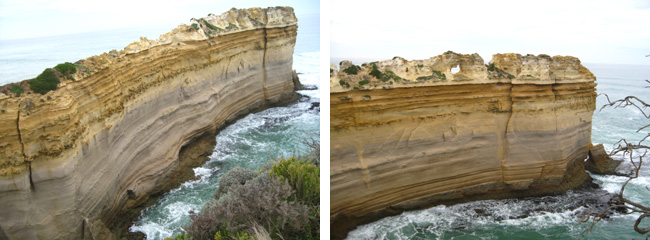
The Razorback
Make your way to WP3.
This rock stack is called "the Razorback". The sharp edges and bumps along its back are caused by wind-blown spray, which hardens small areas of the rock. The softer rock around these erodes away leaving an uneven surface.
Wave energy channelled along the side of the stack carves the deep and smooth grooves just above sea level. With one wave every 14 seconds, there's a lot of erosion over a year, a century, or a millenium!
The Razorback once extended much further out to sea, but the force of the waves is gradually eroding and undercutting the base of the stack. Vertical cracks are also widened and eroded forming lines of weakness, and huge blocks of rock eventually break away and fall into the sea. According to the information panel, what widens the vertical cracks?
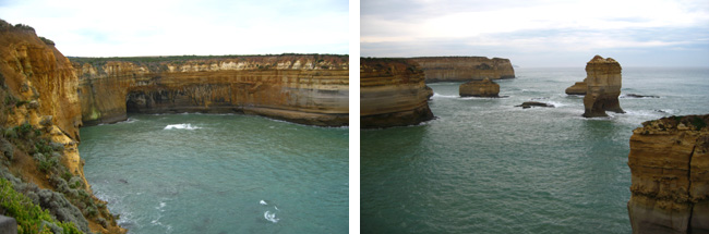
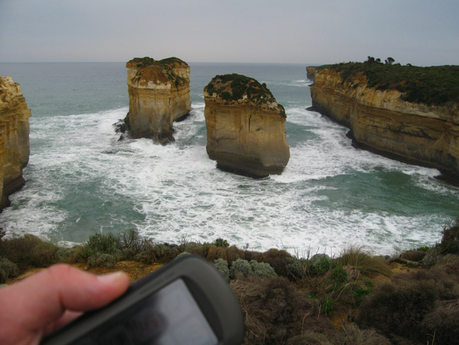
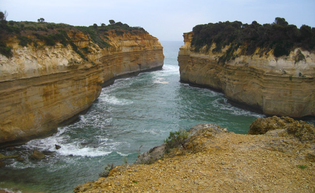
The Island Archway
Make your way to WP4.
The two sea stacks you can see in front of you at this waypoint were, up until June 2009, joined by an impressive archway. Ultimately the roof of the archway reached a point where it could not support itself and it crashed into the sea leaving two separate rock stacks either side. This is a great example of the evolution of the coast line and the relentless erosional forces involved.
Take a photo of the two sea stacks from this waypoint, and include your GPS unit in the photo. An example photo is shown below. Your photo is to be uploaded with your online log in order to claim a find on this earthcache.
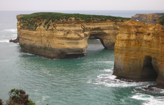
The Wreck
Make your way to WP1, the published coordinates.
From this vantage point, you can see the rocks where the Loch Ard struck a shallow reef and ultimately lost its battle with sea and rock. The captain had set full sail in order to turn the ship away from danger, but wind and current carried the ship close to the cliffs.
The sails were lowered and anchors dropped, but they simply dragged across the sea floor. In a last ditch attempt, the anchors were cut free and sails raised, and the ship began to make headway, but it was too late. All but two onboard were lost to the sea.
Take a photo of the arch you can see from this waypoint, and include your GPS unit in the photo. This photo is to be uploaded with your online log in order to claim a find on this earthcache.
The Gorge
Make your way to WP5.
From this waypoint a set of stairs leads down to the Loch Ard Gorge's beach. It was in this gorge where the two survivors of the Loch Ard wreck came ashore. The other 52 passengers and crew perished in the raging seas.
After the ship went down, Tom Pearce, the ship's apprentice, drifted for hours under an upturned lifeboat. When the tide turned at dawn, he was swept into this gorge.
Shortly after coming ashore, he heard cries from the water and saw Eva Carmichael, an 18 year old Irish immigrant, clinging to wreckage. Tom swam out to her and struggled for an hour to bring her to the beach. Tom later climbed out of the gorge and sought help from stockmen from the nearby Glenample Station.
At the inland end of the gorge, above the beach, there are some interesting geological features on the cliffs. Please describe these features, and offer your theory as to how they have formed.
No photos, or no email with the answers to the questions above, and your log may be deleted.
Please stay on the tracks - there is no need to leave them for any stage of this earthcache. And remember, "take nothing but photographs, leave nothing but footprints"!
You can log this cache straight away after you have emailed your answers to the cache owner, no need to wait for confirmation. Please include the name of this earthcache in the email - you'd be surprised how many people forget. Also, when contacting us with answers, if you want a reply, please include your email address. Any problems with your answers we'll be in touch.
|