| This cache is part of the Seven Wonders of Pike County, a project developed by a team of teachers with the support of the Pike County Conservation District, dedicated to the preservation and appreciation of the great natural and historical sites in Pike County, PA, through education and recreation. There is a limited-time prize available to those who complete all of the Seven Wonders, described on the project's web page. |
At the edge of the Pocono Plateau, the Bruce Lake State Forest Natural Area lies on 2,485 acres and offers over eight miles of forest trails. The natural area encompasses two separate and quite different lakes, Bruce Lake and Egypt Meadow Lake. This natural area has numerous features, which help to tell the geologic story of Pike County of a time long before we hiked its trails.
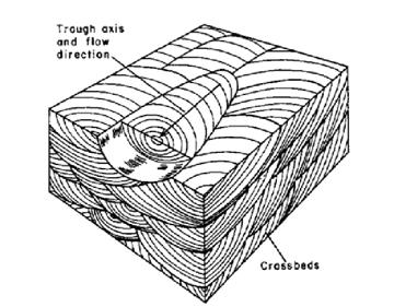
Around 385 million years ago, Pennsylvania was situated south of the Equator. Streams and rivers flowing from the Acadian Mountains (predecessors of the Appalachians) carried sediment towards the western half of Pennsylvania, which at that time was covered by sea. These sediment layers are visible in the cross-bedding seen in outcrops of conglomerate and sandstone rock situated along the trail. In addition, there are large, nearly vertical partings, called joints, which cut through the bedding planes and crossbeds. The spacing of the bedding planes, crossbeds, and joints is the factor that has determined the shape and sizes of the blocks that have broken away from the rock outcrops along the trails.
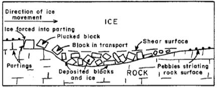
Approximately twenty-one thousand years ago, a massive ice sheet, known as the Wisconsinan glacier, covered this same land. The glacier traveled southward slowly and then receded northward two thousand years later. Estimates determine the natural area may have been covered by 2,000 to 3,000 feet of ice. Many of the geologic features at Bruce Lake have resulted from the glacier’s movement. As it moved, it would break off and move large chunks of rock. These are the massive boulders you see scattered on both sides of the trail. The glacier, moving only inches a day, carried gravel underneath it, scraping the existing rock below, causing parallel groves called striations.
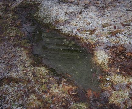
these glacial striations are some that you can see here
|
Bruce Lake was formed as the glacier withdrew, leaving a large iceberg behind. As the iceberg melted, its weight formed a basin in the surrounding rock, thus creating the lake. A lake formed in this manner is commonly referred to as a "Kettle Lake." Bruce Lake covers approximately 40 acres with an average depth of 7 feet and a maximum depth of 20 feet. The lake is fed by groundwater.
Egypt Meadow Lake's history is entirely different than that of Bruce Lake. Measuring 60 acres, it was made in 1935 by the Civilian Conservation Corporation. The adjacent Balsam Swamp, located past and south of Egypt Meadow Lake, drains into the lake. A second swamp, Panther Swamp, named for the animals that once roamed the area, is located on the left of the trail prior to reaching Egypt Meadow Lake. Bruce Lake is not only a spectacular geological specimen, but it also offers a diverse array of flora and fauna. You will see chestnut, red, white, black and scarlet oaks on your path. Red maples, eastern hemlock, firs and spruces also thrive in this habitat. The state flower, mountain laurel, can be easily found in the understory. Another broad-leafed evergreen, the great rhododendron, has larger leaves that droop then curl in low temperatures. Bog rosemary, leatherleaf, blueberry and cranberry plants can be found in the bog located in the southern area of the trail around Bruce Lake. Also present are Pitcher plants, round-leaved sundew and bladderwort, each a unique specimen capable of capturing and digesting insects to obtain nitrogen.
Caution must be used as you may come across some of the animal inhabitants of the habitat, including black bear, white-tailed deer, grey fox, beaver, porcupine and mink. Bald eagles and osprey fly above the waters that contain small and large mouth bass, sunfish and perch. Wild turkeys and the state bird, the ruffed grouse, can also be spotted in the woodlands. Step lightly, as snapping turtles and timber rattlesnakes also roam these trails!
As glaciers and mountain streams helped to form the features discussed above, it is important to remember that geology is a continually dynamic process and the features observed today will likely be different in another twenty thousand years. Presently, it is the biotic features of the habitat that continue to alter the landscape. There are many instances of trees growing in rock formations; their growing roots continually applying pressure to the rock, eventually breaking it apart. This type of physical weathering is best known as root wedging. A symbiotic relationship between fungi and algae called lichen is also quite present. Lichen is known as “pioneer species”, as they can colonize on rock, beginning a process known as succession, or a gradual change in ecosystem. As the lichen secrete enzymes and acids, the rock will breakdown, eventually forming soil that will be hospitable to plants and animals.
Coordinates are provided for the parking lot located at the trailhead for Bruce Lake and a few waypoints along the trail. The completion of this earthcache involves a hike that takes you to geologically interesting features located along the trail to Bruce Lake. In order to get credit for the completion of this earthcache, you must email to us the answers to the following questions:
- The first posted waypoint to which you'll come (N 41° 21.085 W 075° 11.692) is at the bridge crossing Egypt Meadow Lake. Look carefully at the lake in either direction from the bridge. There is no question to answer here, but your observations at this point will be important when you contrast what you see here with what you'll see at Bruce Lake.
- Continue on the trail and go to the coordinates for the rock outcrop (N 41° 20.999 W 075° 11.187). Identify the sedimentary rock feature that is present in the rock outcrop. Also, while at this location, describe two additional geological or biological processes you observe here that continue to slowly change the landscape today.
- Continue farther East on the trail until you come to the next waypoint (N 41° 21.258 W 075° 10.377) When you arrive here, look for the glacial striations in the rock and take note of the compass direction in which they run. In what direction do they run, and why is this important?
- Go to the posted coordinates for this Earthcache and post a photo of yourself and/or your GPS with Bruce Lake in the background.
- As a result of hiking the trail and seeing the two lakes, you should be able to see at least one important, observable difference between Egypt Meadow Lake and Bruce Lake. State one or two important differences you can see and suggest a reason for this difference.
Please email the answers to the following questions to 7wondersofpikecounty@gmail.com:, and do not post any information about these in your post or photos. Each cacher's log should have the photo described above. For eligibility for the pathtag for the Seven Wonders challenge, the required photo should show that cacher with their GPSr at the coordinates as described above.