Valley Earthcache, CCARW10 EarthCache
Valley Earthcache, CCARW10
-
Difficulty:
-

-
Terrain:
-

Size:  (not chosen)
Please note Use of geocaching.com services is subject to the terms and conditions
in our disclaimer.
This cache has been placed for the CCARW10 event, held May 1-2,
2010. This cache was released to the public on April 29, but should
not be located prior to noon, May 1. The caches for the event are
released early so that the caching community has an opportunity to
solve puzzles and plan their routes prior to the event
start.
This cache has been placed as part of the Circle the Wagons
class.

Most of Alberta’s rock and soil was laid down over 2 million
years ago, and not much deposition has occurred since that time.
The sandstone outcrop to the north east is known as the Paskapoo
sandstone, and this formation was deposited about 60 million years
ago. Take note of the limited depth of material above the
sandstone. During the last 2 million years, there were several
periods of glaciation that covered much of North American and
Europe. Alberta was mostly immune to these periods of glaciation
until the last major episode. During this last major ice age, known
as the Wisconsin Glacial Episode, a sheet of ice covered most of
Canada and northern Europe and Asia at thicknesses up to 4000
metres. Alberta was covered in ice up to 3000 metres thick with a
sheet of ice known as the Laurentide Ice Sheet advancing from
Hudson’s Bay, which was met in the west by the advancing
Cordilleran ice sheet. Only some high mountains and parts of Cyprus
Hills and Porcupine Hills escaped the ice. During this period, from
26,000 years ago until about 10,000 years ago, the world’s
sea level fell by about 120 metres due to the water taken up in the
glaciers. Much of the undulating terrain in Alberta and our
drainage systems were created by the advancing and subsequent
melting of these large sheets of ice.

Many valleys in Alberta were carved by the large volume of water
running off the glacier to the sea. The volume of water flowing in
our current streams and rivers is only a small fraction of the
volume that was flowing during the melting of the ice. Some of the
water would have flowed in incrementally large rates when large
lakes forming on the top of the glacier suddenly broke through the
edges of the glacier. It is speculated that some deep valleys in
the mountains and elsewhere were formed within days when ice dams
broke, suddenly releasing large floods of water, and deeply
scouring the landscape with these releases. The steeply eroded
valley to the north was created with the melt water draining the
higher land to the north to the lower valley to the south. The
valley you are looking at to the south and east was scoured by the
advancing ice, and it would have been wet with the melt water
10,000 years ago when the melting ice sheets gave the nearby stream
(Beddington Creek, passing under the bridge to the west of here)
plenty of water for its source.
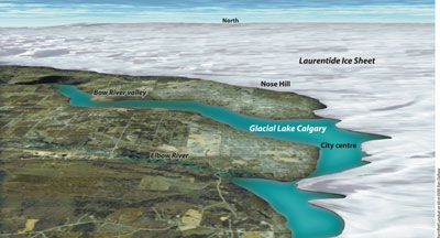
Both illustrations are from Natural
Resources Canada
When the existing stream has a flow rate that is too low to have
carved the valley in which it is contained, it is known as a misfit
stream.
Please email us your estimates to the following
questions:
1) How wide is Beddington Creek passing under the nearby
bridge?
2) How wide is the valley at this location, and what is the
elevation change from the top of the valley to the creek?
Please post your log after sending us your answers, and include a
photo of the valley with your GPSr.
You may be interested in the other nearby caches that form part
of this series of caches:
Additional Hints
(No hints available.)