Narodni prirodni pamatka Odkryv se nachazi na katastralnim
uzemi Kravare ve Slezsku v prostorech byvale piskovny, priblizne
1km severozapadne od Kravar. Ma rozlohu 1,64 ha.
Prirodni pamatkou byla vyhlasena v roce 1966.
Težba písku zde odkryla jedinecný profil umelého odkryvu
hlinených ledovcových usazenin, složením odpovídající
vetšinou hlinitým pískum až píscitým hlínám z období
sálského kontinentálního zalednení ve starších ctvrtohorách
(asi pred 300 000 lety).
Lokalita je napojena do trasy tuzemských i mezinárodních exkurzí,
zabývajících se problematikou geologie ctvrtohor. Byla zpracována v
rámci IUGS - UNESCO International Geologikal Correlation
Programe.
Nejcennejším a druhove nejbohatším pro kvetenu je
prostor sten i vrcholu malé pískovny a stena velké
pískovny
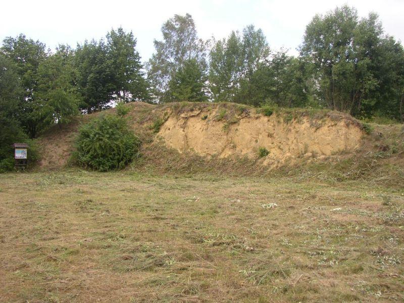
V severní stene pískové jámy je odkryt relikt náporové
celení morény na jejíž stavbe se úcastní nekolik zrnitostne i
geneticky rozdílných sedimentu.
Základním sedimentem jsou hnedave okrove žluté souvkové
píscité hlíny, ve kterých jsou nepravidelne roztroušeny
souvky, prípadne i eratické bloky z nordických hornin (kremen,
severská žula, biotitická rula, kvarcit, pazourek, rohovec),
jakož i z hornin domácího puvodu (kremen, kulmská droba,
ortorula a cedic).
V souvkové píscité hlíne jsou uzavreny dve velké kry rzive hnedého
limonitového šterkopísku, který je považován za
glaciofluviální sediment. Zvrstvení je prevážne horizontální.
Svrchní hrana ker je lemována oranžovou limonitickou obrubou,
která vznikla sekundárne vzlínáním hydroxidu Fe 3+. V levé a
strední cásti nasedají souvkové píscité hlíny ostre na
šedave hnedožluté jemnozrnné glaciofluviální píscité
šterky, které obsahují (zvlášte na rozhraní mezi
obema typy sedimentu) rozvlecené jílovité cocky.
V soucasnosti je velká cást steny zasuta. V pravé polovine profilu
proniká píscitojílovité souvkové hlíny, jejíž barva je na
cerstvém odlomu hnedofialove cervená.
Ve dne jámy byla provedena orientacní kopaná sonda, z níž je
zrejmé, že na lokalite je víc než 11 m glacigenních
sedimentu, náležejících celní náporové moréne - saale.
Nadmorská výška nejvyššího místa profilu ciní
261 m n.m.
Podmínkou uznání logu je:
1. Prilozit svou fotografii se stenou VELKÉ pískovny v pozadí
(nikoliv malé)
E-mailem zaslat odpovedi na otázky :
2. Kdy bylo uzemi vyhlaseno prirodni pamatkou? (den, mesic,
rok)
3. Co je znázorneno na obrázku c.4 informacní tabule?
Necekejte na potvrzení, v prípade chybejících informací Vás budu
kontaktovat (nebo smažu Váš log :))
EN:
National Natural Monument Odkryv is located in the
cadastral territory Kravare in Silesia, a former sand pit in an
area approximately 1 km northwest of Kravar. Odkryv has an area of
1.64 hectares. Natural monument was established in 1966. Sand
reveal here a unique profile of artificial uncovering glacial
deposits of clay, the composition corresponding mostly loamy sands
to sandy loam, from the period of continental glaciation Saale in
older Quaternary (about 300 000 years ago). The location is
connected to route domestic and international excursions, dealing
with the Quaternary geology. It was processed within IUGS - UNESCO
International Geological Correlation Program. The most valuable
species and the flora is the richest area of the walls and top of
small sand and large sand wall.
In the north wall of the sand pit is
uncovered relic ramjet frontal moraine of which involved the
construction of several genetically distinct fractions and
sediment. Basic sediments are brownish-yellow ocher clastics sandy
loams, in which are irregularly scattered put, possibly erratics
blocks from the Nordic rocks (quartz, northern granite, biotite
gneiss, quartzite, flint, chert), as well as indigenous rocks
(quartz, Culm Greywacke , orthogneisses and basalt). In clastics
sandy loam are signed two large plates rusty brown limestone
gravel, which is considered glaciofluvial sediment. Layering is
predominantly horizontal. Outer edge of the floes is lined with
orange limestone trim, which was secondary to capillary action
hydroxide Fe 3 +. In the left and middle part are got in clastics
sandy loams sharp on greyish brownish glaciofluvial grained sandy
gravels, which contain (especially at the interface between the two
types of sediment) lengthiness clay lenses. Today is hidden a big
part of the wall. In the right half profile penetrates sandy clay
clastics loam, whose colour is puce red on fresh peak. In the
bottom of the pit was performed indicative soccer probe, from which
it is clear that on the site is more than 11 m of glacigenic
sediments, belonging to the frontal moraine ramjet - Saale.
Altitude the highest point of the profile is 261 m.
Condition for the recognition of the
logo is:
1. Attach your photograph to the wall behind the large sand.
E-mail to send answers to the questions:
2. When the territory was declared a natural monument? (day, month,
year).
3. As shown in Figure no.4 information board?
Do not wait for confirmation, in the case of the missing
information will contact you (or delete your
log:))