|
The Emerald Lakes
GEOLOGY
The Tongariro National Park covers an area of young volcanoes all still active to some degree. Mt Ruapehu to the south, and the tallest of the three mountains, last erupted significantly in 1995 and 1996 including several lahars and the emptying of the crater lake. More recent activity, in 2007 was the generation of a lahar of an estimated 1.4 million cubic metres of mud, rock, and water that thundered down the Whangaehu river after the tephra dam holding back the crater lake burst. Later in 2007, activity also included a hydrothermal eruption where rocks were ejected, one of which crushed the Dome hut.
Ngauruhoe, in the middle, is the youngest of the three volcanoes, having begun formation only 2500 years ago. It presents today as a classic cone volcano, and will be remembered by Lord of the Rings fans as Mt Doom, the part it played in the epic movie trilogy. While most view Ngauruhoe as a separate volcano, it is actually a secondary cone of the Tongariro volcanic complex. Mt Ngauruhoe was most recently active in 1975 and erupted 45 times last century. Until recent times, usually Ngauruhoe could be seen to be producing steam from its crater. Ngauruhoe's eruptions have seldom been more than nine years apart however its steam vents have temporarily cooled, suggesting that the main vent has become blocked and there has been no further activity of any significance since 1975.
Mt Tongariro is the oldest of the three mountains, approximately 10,000 years older than Ruapehu, having first erupted around 260,000 years ago. Consisting of 12 cones, and containing the highest geothermally active system in the country, the most recent significant activity from Tongariro was an eruption of ash from Red Crater, central to the volcanic complex, in 1926. Hot springs and active steam vents can be found in a number of areas on the massif.
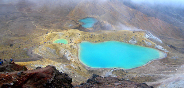
This earthcache will take you to the beautiful Emerald Lakes on top of Mt Tongariro. These lakes, were formed by explosion craters that have subsequently filled with water. They are set amongst steam and sulphur vents responsible for the odour around the lakes, most noticeable when there is an easterly or south easterly wind. This is a popular lunch spot for walkers of the crossing. The vivid colouring of the lakes is the result of minerals leeching into the water from the surrounding volcanic rock, and washed down from Red Crater above and to the south.
The tapu Blue Lake, sacred to the Maori, also formed from an explosion crater, is located further to the north. To the west of the Emerald Lakes is a large lava flow extending into the Central Crater from Red Crater, the site of the most recent activity on Tongariro.
|
|
THE TONGARIRO ALPINE CROSSING
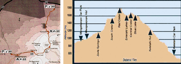
To access this earthcache you will need to walk the 19.4km Tongariro Alpine Crossing track, considered by National Geographic as one of the top ten day walks in the world. The crossing takes approximately 6 to 8 hours to walk comfortably from the usual start at the Mangatepopo Valley carpark to the Ketetahi carpark, perhaps plus some extra time for stops along the way, like searching for caches.
If you plan to walk the crossing, you should be aware that you will need to be prepared to spend a number of hours in an alpine area with no shade or vegetation, and no drinking water. A reasonable level of fitness and outdoors confidence is required to undertake the walk and you should go prepared with plenty of water, food and warm waterproof clothing. A map and elevation chart are shown below.
It is a highly recommended walk very popular with overseas tourists, crossing geologically young and active terrain, and affording spectacular views of other mountains and the surrounding central volcanic plateau - just don't hesitate to turn back if the weather turns, and remember the emergency telephone number in New Zealand is 111. More information can be obtained on the official website.
|
|
THIS EARTHCACHE
To claim a find on this earthcache you will need to perform the tasks described below. Failure to provide the required answers via email, or upload the required photo with your online log may result in your log being removed.
1 Using your GPS unit, what is the elevation or altitude of each of the three lakes? The answer to this question must be emailed to the cache owner.
2 Please describe in your own words, and creatively as possible, the colour of the lakes. The answer to this question must be emailed to the cache owner.
3 From the published coordinates, or nearby, please take a photo of the lakes showing your GPS unit. This photo should be uploaded with your online log.
You can log this cache straight away after you have emailed your answers to the cache owner, no need to wait for confirmation. Please include the name of this earthcache in the email - you'd be surprised how many people forget. Also, when contacting us with answers, if you want a reply, please include your email address. Any problems with your answers we'll be in touch.
|