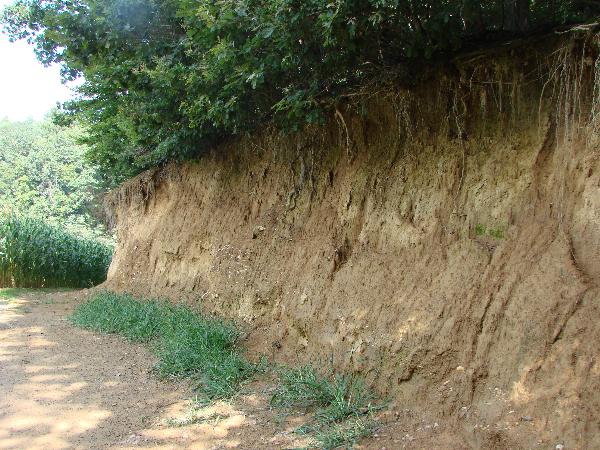
Im Gebiet der Gemeinde Baumgarten treten Ablagerungsgesteine unterschiedlichen Alters an die Erdoberfläche.
Geologen und Paläologen können aus diesen Urkunden der Erdgeschichte die Umweltbedingungen langer zurückliegender Zeitalter rekonstruieren.
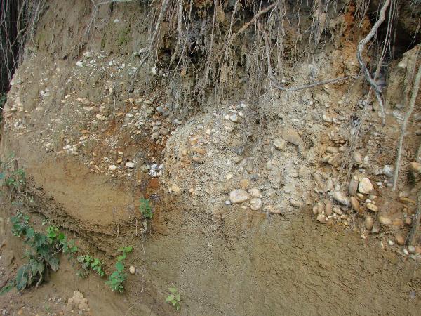
Vor 12 Millionen Jahren - in der Zeitstufe des Sarmatium – bedeckte ein flaches Meer weite Teile der Oststeiermark. In diesem Meer wurden Kalke, Sande, Kiese und Tone/Silte abgelagert, die unter der Bezeichnung Gleisdorf-Formation zusammengefasst werden.
Vor 11,5 Millionen Jahren - zu Beginn des Panonium - wurden die Verbindungen zu anderen Meeresgebieten durch Gebirgsbewegung geschlossen und es entstand der kaum noch salzige „Pannonische See“.
In diesem Seebecken gelangte feinkörniges Material zur Ablagerung – die Feldbach Formation.
Meerestiere konnten aufgrund des geringen Salzgehaltes nicht mehr leben. Einige Muscheln und Schnecken erlebten jedoch eine Blütezeit.
Vor 11 Millionen Jahren – noch im Pannonium – begann sich der „Pannonische See“ in den ungarischen Raum zurückzuziehen.
Flüsse brachten Kies, Sand und Ton in das Becken ein. Die weitläufig mäandrierenden Flüsse ermöglichten in den Überschwemmungsgebieten durch Versumpfung die Bildung von Kohle (z.B. Paldau). Ur-Pferde und Ur-Elefanten bevölkerten die Auwälder. Diese Sedimente werden als Paldau-Formation bezeichnet.
Obwohl die Erdschichtenwand in Wörth nicht besonders groß ist, erzählt sie uns doch einiges über die Geologie der Oststeiermark.
Logbedingungen:
Beantworte die folgenden Fragen per E-Mail:
1.) Beschreibe den „Ooidkalk“ der häufig zu Bauzwecken genutzt wurde.
2.) Nenne die Muschelart, die ihre Blütezeit in der Feldbach-Formation hatte.
3.) Beschreibe die heutigen Talböden, wie sie auf der Informationstafel geschildert werden.
Füge dem Online-Log ein Bild von Dir (mit oder ohne GPS) vor der Erdschichtenwand hinzu, bitte ohne Informationsschild (optional).
In the area of Baumgarten in the eastern part of Styria you can see at a certain place sediments of different ages at the earth’s surface.
Out of these layers it was possible to reconstruct the environmentals conditions of our geolocigal past.
12 Million years ago great parts of eastern styria were coverd by a shallow ocean. At the bottom lime, sand, gravel and clay (silt) werde deposited, known as „Gleisdorf-Formation“.
At the beginning of the age of Pannonian the connection to other oceans was closed by foldings of mountains and the „Pannonian Lake“ was formed. At the bottom of this lake very fine grained material settled – the „Feldbach-.Formation“.
Animals accustomed to live in salty waters could not any longer survive. A few mussels and snails however bloomed.
Then 11 Million years ago the Pannonian Lake began to move to Hungary. Rivers brought gravel, sand and clay into this region and together with the meandering streams the „Paldau-Formation“ evolved. Geologist know of coal layers and preshistoris horses und elephants which roamed the area at this time.
So the layers of earth tell you here in Wörth a lot about geological history of Eastern Styria.
In order to log this cache please mail me the answers to the following questions:
a) Describe the „Ooid-Lime“ (Ooidkalk), which was often used to build houses.
b) Which mussels had the „Heyday“ of their life in the Pannonian Lake?
c) Describe the valley floors of today as it is stated on the informationboard.
It would be nice if you could add a picture of yourself - preferably showing your gps-receiver - to your online log, taken at the location but not before the information board.